

SUN RETURNS MONDAY
Monday is going to be a day of clearing skies and high temperatures of 75 to 80 degrees. Tuesday is going to be a Dandy with sunshine and again 75 to 80 and low humidity to enjoy. It is going to get h ...
THUNDERSTORM POSSIBLE TONIGHT
The greatest threat of storms on the plateau this evening will run from 10 p.m. tonight until 4 a.m. in the morning and then Skies will go back to partly cloudy for Monday with a high in the upper 70s ...
A FEW STORMS POSSIBLE
We are going to settle into a weather pattern of partly cloudy and warm through Sunday with a Chance of afternoon and evening thunder showers. 30% chances for Friday and Sunday with 50% on Saturday be ...
A FEW THUNDERSTORMS COMING BACK
We are going to settle into a weather pattern of partly cloudy and warm through Sunday with a Chance of afternoon and evening thunder showers. 30% chances for Friday and Sunday with 50% on Saturday be ...
A FEW STORMS BY FRIDAY
Thursday will be another beautiful day with sunshine and temperatures in the low 80s, just some clouds drifting through from time to time. A few afternoon and evening thunderstorms will come back into ...
SUNNY AND WARMER
It is going to feel like summertime all week across Cumberland County and East Tennessee with sunshine and dry weather and highs in the 80s which is getting close to record levels for early May. Scatt ...
COOL DAMP SATURDAY
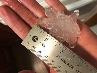
Pea to marble-sized hail was common in many of the storms across Cumberland County today but we did get reports of golf ball-sized hail in the Lake Tansi area and look at this Stone. Anytime you get g ...
COOL SATURDAY – TORNADO THREAT GONE
The tornado watch has been cancelled for the Cumberland Plateau including Cumberland County. We will have a chance of showers again tonight and tomorrow with much better weather moving in on Mother's ...
TORNADO WATCH TILL 7PM
A tornado watch is in effect until 7 p.m. for the Cumberland Plateau including Cumberland, Fentress and Bledsoe County. All of East Tennessee is also under the watch. Numerous thunderstorms will be ...
MORE RAIN TONIGHT & FRIDAY
A few severe thunderstorms developed over Middle Tennessee late Thursday with the most severe weather over White County and the Very Western portion of Cumberland County. We had several reports of tre ...
RAIN RETURNS THURSDAY NIGHT
Clear skies tonight with low temperatures near 52. Partly sunny Thursday with highs 75 to 80 degrees. Showers and thunderstorms will come Thursday night and Friday and a few could be severe across the ...
NICE WEDNESDAY
Overnight scattered showers and thunder showers moving across Tennessee but they will get out of the area for your Wednesday with a high of 75 to 80 and partly sunny, looks like it will be a great day ...