

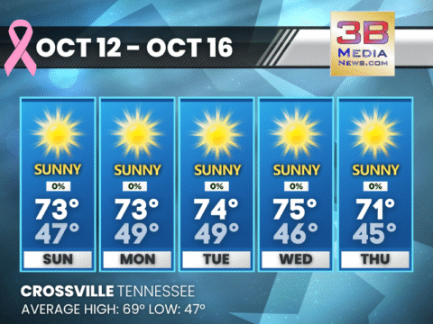
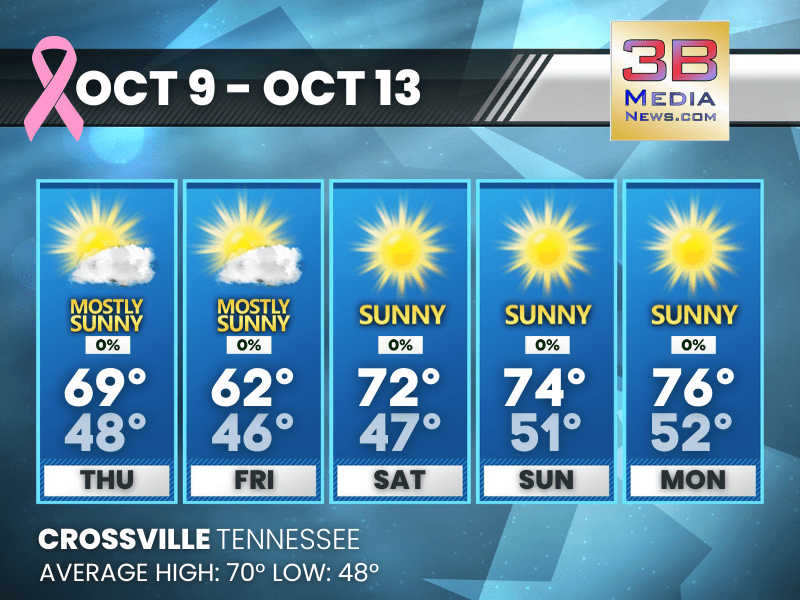
SUNNY DAYS AHEAD WITH COOL NIGHTS THROUGH FRIDAY
A stretch of pleasant weather continues this week, with highs in the low to mid 70s and clear, cool nights dipping into the 40s and
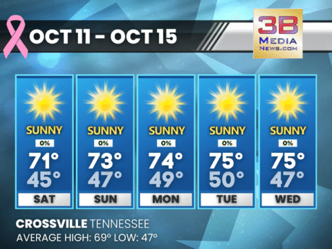
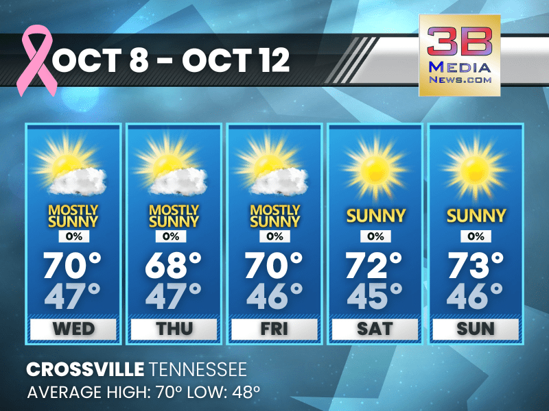
PLEASANT FALL WEATHER CONTINUES THROUGH MIDWEEK
Expect sunny skies, mild afternoons in the low to mid-70s, and cool nights in the 40s through Thursday. Sunday: Sunny, with a high near 73. North
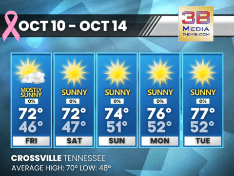
SUNNY AND SEASONABLE WEATHER CONTINUES THROUGH MIDWEEK
Expect clear skies, light winds, and highs in the low to mid-70s with cool, comfortable nights. Saturday: Areas of fog before 9am. Otherwise, sunny, with a
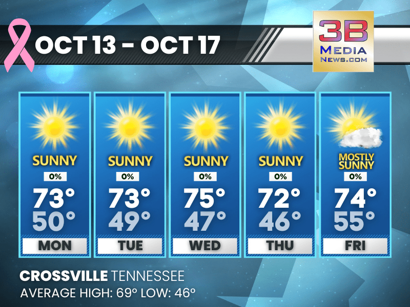
SUNNY SKIES AND MILD TEMPERATURES THROUGH EARLY NEXT WEEK
Expect mostly sunny days with highs in the low to upper 70s and calm winds, along with clear and cool nights. Friday: Mostly sunny, with a

MOSTLY SUNNY DAYS, CLEAR NIGHTS AHEAD
Pleasant weather continues through the weekend with highs in the 70s, cool nights, and occasional morning fog. Today: Mostly sunny, with a high near 69. Northeast

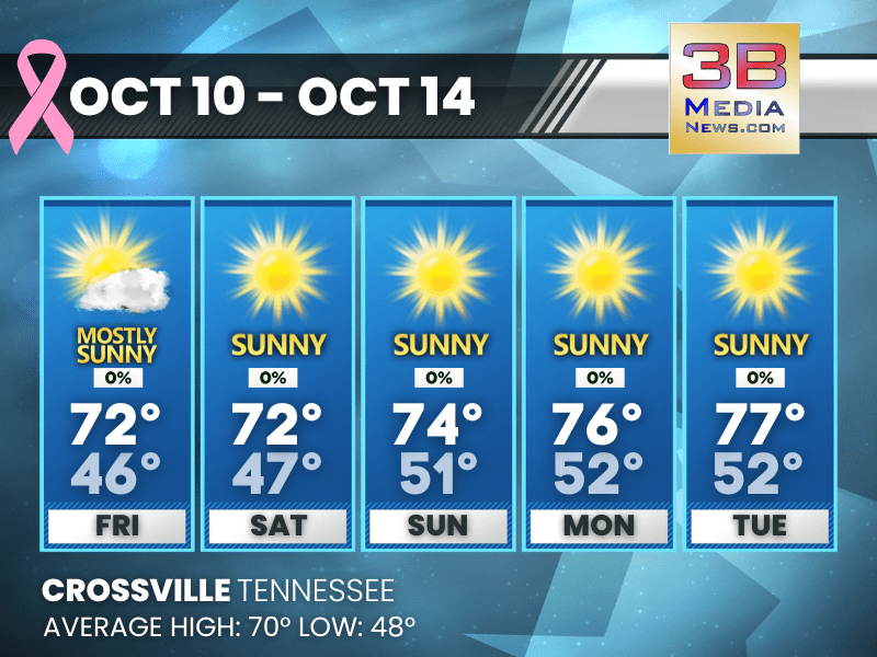
SUNNY STRETCH AHEAD WITH COOL NIGHTS
Clouds break Wednesday with highs near 70, leading into several days of sunshine and cool nights in the mid-40s. Wednesday: Cloudy, then gradually becoming mostly sunny,

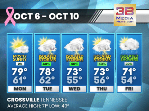
SHOWERS AND STORMS EARLY THIS WEEK, SUNSHINE RETURNS BY THURSDAY
A wet Tuesday and Tuesday night give way to clearing skies midweek, with cooler, sunny days ahead through the weekend. Tuesday: A chance of showers and
WARM START TO THE WEEK, THEN STORMS MIDWEEK
Mostly sunny Monday gives way to increasing rain and storm chances Tuesday through Thursday, with cooler, unsettled weather lasting into the weekend. Monday: Mostly sunny, with

HARVEST SUPERMOON TO DOMINATE OCTOBER SKY ON MONDAY NIGHT
Skywatchers across North America are preparing for a dazzling celestial spectacle: the full moon will peak on Monday, October 6, 2025, at 11:47 p.m. Eastern
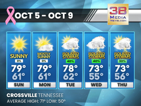
SUNNY START TO THE WEEK, SHOWERS RETURN TUESDAY
The week begins with sunshine and mild temperatures before rain and thunderstorms move in Tuesday through Thursday. Sunday: Sunny, with a high near 79. Southeast wind
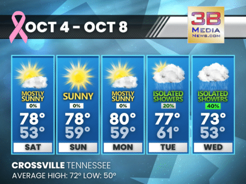
WARM AND MOSTLY SUNNY WEEKEND AHEAD, SHOWERS RETURN MIDWEEK
Fog clears early Saturday before sunshine dominates the weekend. Rain chances return Tuesday night into Wednesday. Saturday: Areas of fog before 8am. Otherwise, mostly sunny, with

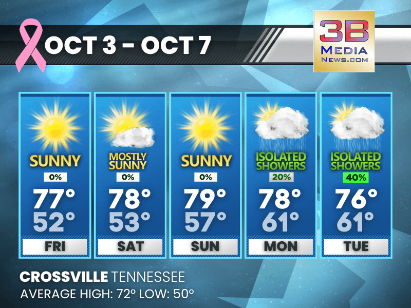
SUNNY WEEKEND AHEAD WITH RAIN CHANCES EARLY NEXT WEEK
Expect sunshine and mild temperatures through Sunday, with increasing chances for showers and thunderstorms by Monday night into Tuesday. Today: Sunny, with a high near 77.
SUNNY DAYS AHEAD WITH COOL NIGHTS THROUGH FRIDAY
A stretch of pleasant weather continues this week, with highs in the low to mid 70s and clear, cool nights dipping into the 40s and 50s. Monday: Patchy fog before 8am. Otherwise, sunny, with a high ...

PLEASANT FALL WEATHER CONTINUES THROUGH MIDWEEK
Expect sunny skies, mild afternoons in the low to mid-70s, and cool nights in the 40s through Thursday. Sunday: Sunny, with a high near 73. North wind around 5 mph. Sunday Night: Mostly clear, w ...

SUNNY AND SEASONABLE WEATHER CONTINUES THROUGH MIDWEEK
Expect clear skies, light winds, and highs in the low to mid-70s with cool, comfortable nights. Saturday: Areas of fog before 9am. Otherwise, sunny, with a high near 71. Calm wind becoming north no ...
SUNNY SKIES AND MILD TEMPERATURES THROUGH EARLY NEXT WEEK
Expect mostly sunny days with highs in the low to upper 70s and calm winds, along with clear and cool nights. Friday: Mostly sunny, with a high near 72. Calm wind becoming southeast around 5 mph. ...
MOSTLY SUNNY DAYS, CLEAR NIGHTS AHEAD
Pleasant weather continues through the weekend with highs in the 70s, cool nights, and occasional morning fog. Today: Mostly sunny, with a high near 69. Northeast wind around 5 mph. Tonight: Pat ...
SUNNY STRETCH AHEAD WITH COOL NIGHTS
Clouds break Wednesday with highs near 70, leading into several days of sunshine and cool nights in the mid-40s. Wednesday: Cloudy, then gradually becoming mostly sunny, with a high near 70. North ...
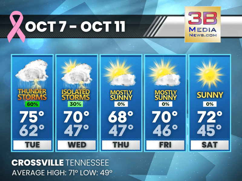
SHOWERS AND STORMS EARLY THIS WEEK, SUNSHINE RETURNS BY THURSDAY
A wet Tuesday and Tuesday night give way to clearing skies midweek, with cooler, sunny days ahead through the weekend. Tuesday: A chance of showers and thunderstorms before 11am, then showers likel ...

WARM START TO THE WEEK, THEN STORMS MIDWEEK
Mostly sunny Monday gives way to increasing rain and storm chances Tuesday through Thursday, with cooler, unsettled weather lasting into the weekend. Monday: Mostly sunny, with a high near 79. Sout ...

HARVEST SUPERMOON TO DOMINATE OCTOBER SKY ON MONDAY NIGHT
Skywatchers across North America are preparing for a dazzling celestial spectacle: the full moon will peak on Monday, October 6, 2025, at 11:47 p.m. Eastern Time, marking the arrival of the Harvest Mo ...
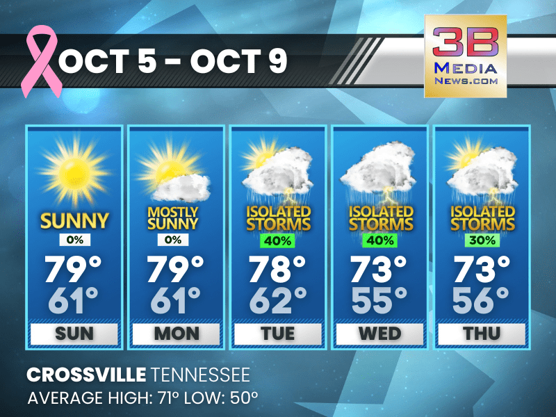
SUNNY START TO THE WEEK, SHOWERS RETURN TUESDAY
The week begins with sunshine and mild temperatures before rain and thunderstorms move in Tuesday through Thursday. Sunday: Sunny, with a high near 79. Southeast wind 5 to 10 mph. Sunday Night: ...

WARM AND MOSTLY SUNNY WEEKEND AHEAD, SHOWERS RETURN MIDWEEK
Fog clears early Saturday before sunshine dominates the weekend. Rain chances return Tuesday night into Wednesday. Saturday: Areas of fog before 8am. Otherwise, mostly sunny, with a high near 78. C ...
SUNNY WEEKEND AHEAD WITH RAIN CHANCES EARLY NEXT WEEK
Expect sunshine and mild temperatures through Sunday, with increasing chances for showers and thunderstorms by Monday night into Tuesday. Today: Sunny, with a high near 77. Calm wind becoming north ...