
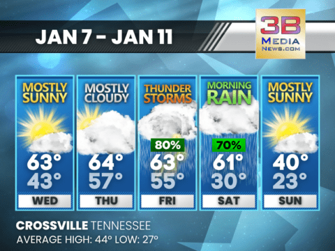
MIDWEEK WARMTH GIVES WAY TO STORMS AND A SHARP COOL-DOWN
Mild temperatures continue midweek before thunderstorms Friday and much colder air arrives for the weekend. Wednesday: Patchy fog between 8am and 9am. Otherwise, mostly sunny, with
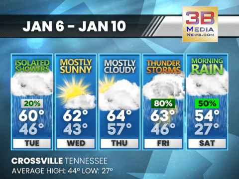
MILD JANUARY STRETCH WITH RAIN CHANCES LATE WEEK
Above-average temperatures continue through the week, with increasing rain and a chance of thunderstorms by Friday before cooler rain arrives Saturday. Tuesday: A slight chance of
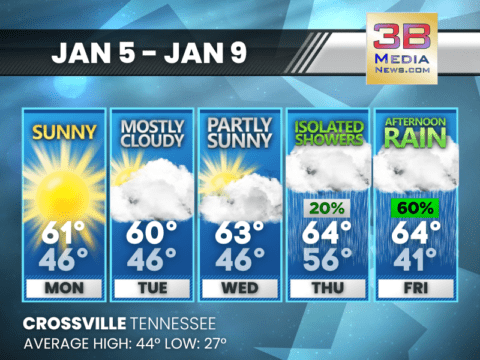
WARM START, RAIN LATE WEEK
Crossville warms into the low to mid 60s through midweek before rain chances increase late Thursday into Friday. Today: Sunny, with a high near 61. Southwest
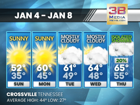
WARMING TREND BUILDS INTO MIDWEEK WITH RAIN CHANCE LATE
After a sunny and cool start to the week, temperatures climb steadily into the 60s by midweek with isolated showers possible by Thursday. Sunday: Sunny, with
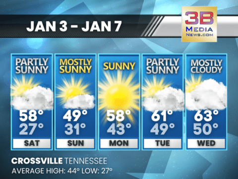
SUNSHINE DOMINATES WITH A WARMING TREND INTO MIDWEEK
Crossville stays mostly sunny through Tuesday with temperatures climbing well above average by Wednesday. Saturday: Partly sunny, with a high near 58. Calm wind becoming northwest
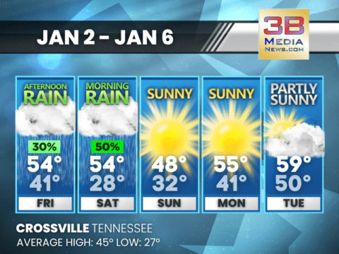
WET START, BRIGHTER FINISH TO THE FIRST FULL WEEK OF JANUARY
Showers linger into Saturday, then sunshine takes control with cool mornings and a steady warm-up through Tuesday. Friday: A 30 percent chance of showers, mainly after
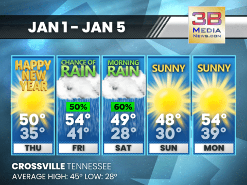
SUNNY NEW YEAR, RAIN LATE FRIDAY INTO SATURDAY
The new year starts bright and mild before clouds and showers move in late Friday and linger into Saturday, with sunshine returning afterward. New Year’s
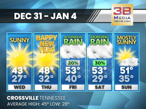
SUNNY START TO THE NEW YEAR, RAIN CHANCES RETURN BY WEEKEND
Sunshine dominates through New Year’s Day before clouds and occasional showers arrive late in the week and into the weekend. Wednesday: Sunny, with a high near
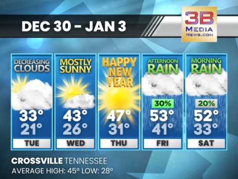
COLD START, MILD FINISH TO THE WEEK
Crossville starts the week below average before sunshine and rain bring a warmer finish into the New Year. Tuesday: Cloudy through mid morning, then gradual clearing,
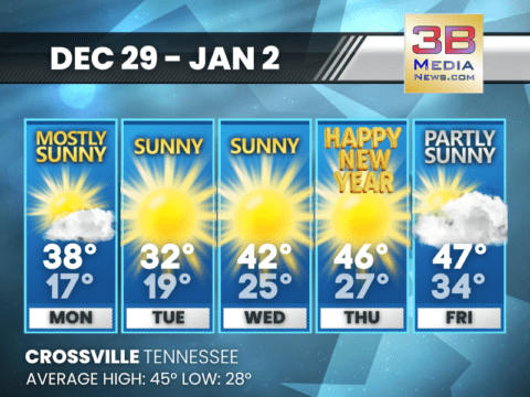
COLD START GIVES WAY TO SEASONABLE TEMPERATURES BY NEW YEAR
After a chilly beginning to the week, temperatures return closer to normal by Thursday. Monday: Mostly sunny, with a high near 38. West northwest wind around

STRONG WINDS PROMPT ADVISORIES ACROSS MIDDLE AND EAST TENNESSEE
A Wind Advisory is in effect across parts of Tennessee late Sunday into early Monday as strong winds move through the region, according to the
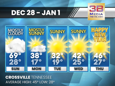
WARM SUNDAY, SHARP COOL-DOWN, SUNNY START TO THE NEW YEAR
Crossville sees a brief warm-up Sunday, followed by a quick turn colder and several bright, dry days heading into New Year’s Day. Today: Mostly cloudy, with
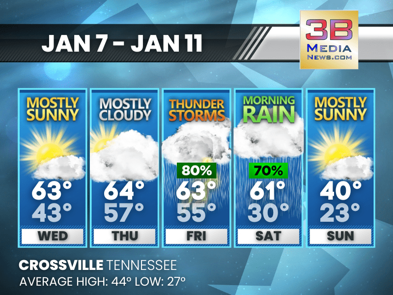
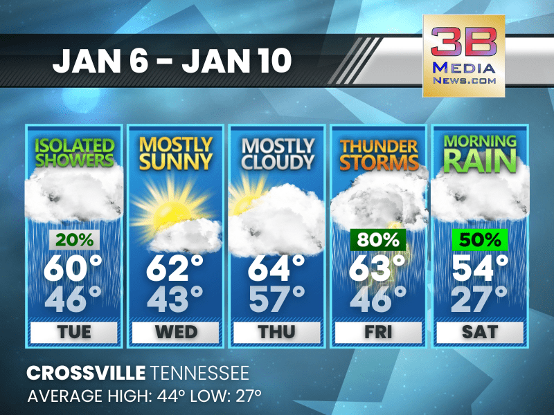
MIDWEEK WARMTH GIVES WAY TO STORMS AND A SHARP COOL-DOWN
Mild temperatures continue midweek before thunderstorms Friday and much colder air arrives for the weekend. Wednesday: Patchy fog between 8am and 9am. Otherwise, mostly sunny, with a high near 63. ...
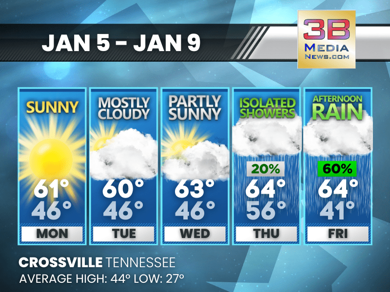
MILD JANUARY STRETCH WITH RAIN CHANCES LATE WEEK
Above-average temperatures continue through the week, with increasing rain and a chance of thunderstorms by Friday before cooler rain arrives Saturday. Tuesday: A slight chance of showers between 7 ...
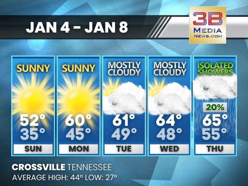
WARM START, RAIN LATE WEEK
Crossville warms into the low to mid 60s through midweek before rain chances increase late Thursday into Friday. Today: Sunny, with a high near 61. Southwest wind 5 to 10 mph, with gusts as high as ...
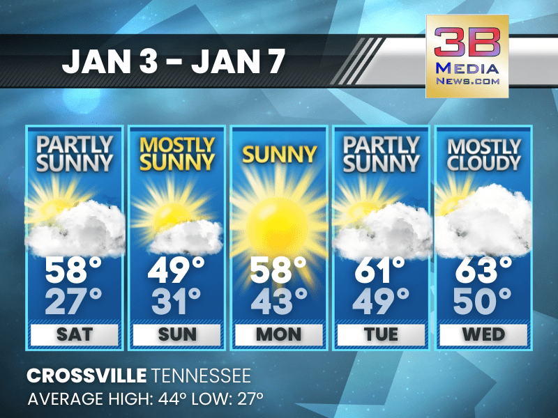
WARMING TREND BUILDS INTO MIDWEEK WITH RAIN CHANCE LATE
After a sunny and cool start to the week, temperatures climb steadily into the 60s by midweek with isolated showers possible by Thursday. Sunday: Sunny, with a high near 52. Calm wind. Sunday Ni ...
SUNSHINE DOMINATES WITH A WARMING TREND INTO MIDWEEK
Crossville stays mostly sunny through Tuesday with temperatures climbing well above average by Wednesday. Saturday: Partly sunny, with a high near 58. Calm wind becoming northwest around 5 mph. ...
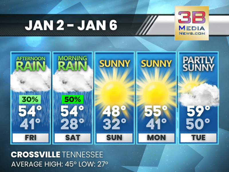
WET START, BRIGHTER FINISH TO THE FIRST FULL WEEK OF JANUARY
Showers linger into Saturday, then sunshine takes control with cool mornings and a steady warm-up through Tuesday. Friday: A 30 percent chance of showers, mainly after 4pm. Mostly cloudy, with a hi ...
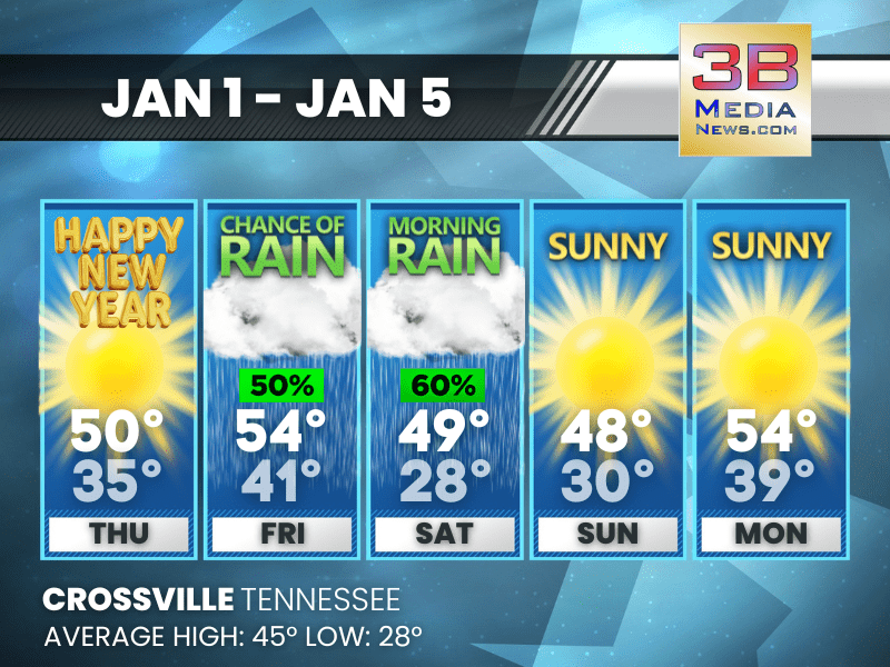
SUNNY NEW YEAR, RAIN LATE FRIDAY INTO SATURDAY
The new year starts bright and mild before clouds and showers move in late Friday and linger into Saturday, with sunshine returning afterward. New Year's Day: Sunny, with a high near 50. Calm wind ...
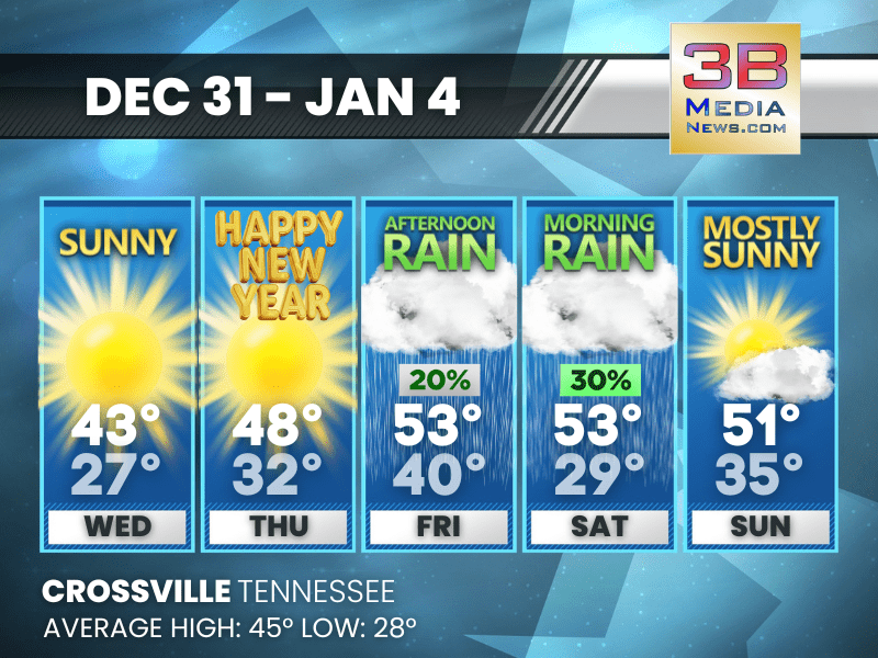
SUNNY START TO THE NEW YEAR, RAIN CHANCES RETURN BY WEEKEND
Sunshine dominates through New Year’s Day before clouds and occasional showers arrive late in the week and into the weekend. Wednesday: Sunny, with a high near 43. West southwest wind 5 to 10 mph, ...

COLD START, MILD FINISH TO THE WEEK
Crossville starts the week below average before sunshine and rain bring a warmer finish into the New Year. Tuesday: Cloudy through mid morning, then gradual clearing, with a high near 33. Northwest ...
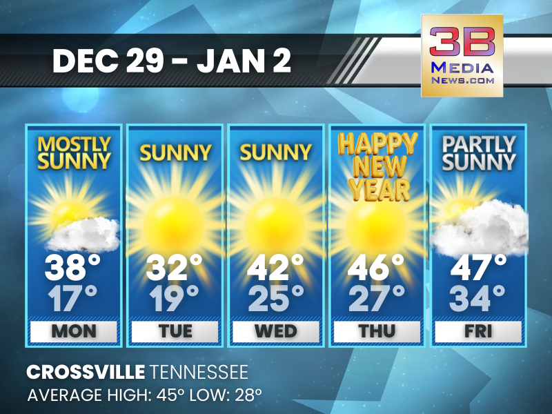
COLD START GIVES WAY TO SEASONABLE TEMPERATURES BY NEW YEAR
After a chilly beginning to the week, temperatures return closer to normal by Thursday. Monday: Mostly sunny, with a high near 38. West northwest wind around 15 mph, with gusts as high as 30 mph. ...

STRONG WINDS PROMPT ADVISORIES ACROSS MIDDLE AND EAST TENNESSEE
A Wind Advisory is in effect across parts of Tennessee late Sunday into early Monday as strong winds move through the region, according to the National Weather Service. In Middle Tennessee, the adviso ...
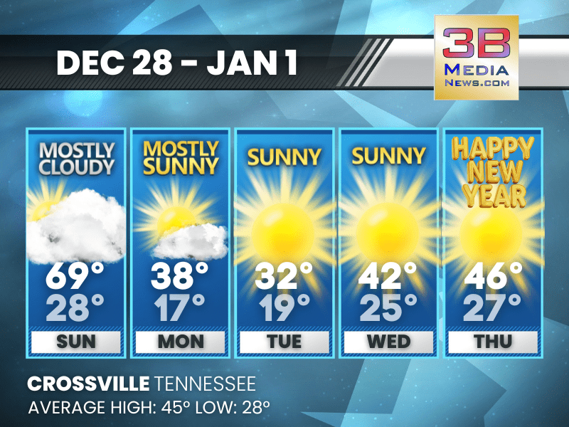
WARM SUNDAY, SHARP COOL-DOWN, SUNNY START TO THE NEW YEAR
Crossville sees a brief warm-up Sunday, followed by a quick turn colder and several bright, dry days heading into New Year’s Day. Today: Mostly cloudy, with a high near 69. South southwest wind 5 t ...
