
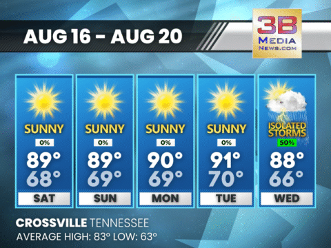
SUNNY WEEKEND WITH FOGGY MORNINGS, STORMS BY MIDWEEK
Expect sunshine and calm winds through Tuesday, with patchy morning fog and a chance of midweek storms starting Wednesday. Saturday: Patchy fog before 8am. Otherwise, sunny,
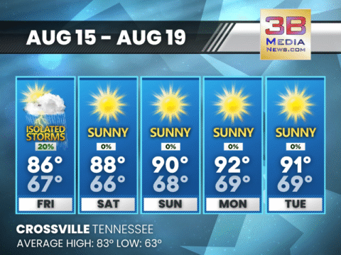
SUNNY WEEKEND AHEAD WITH WARM TEMPERATURES
Foggy mornings will give way to sunny afternoons through Monday, with highs climbing into the upper 80s and low 90s. Friday: A 20 percent chance of
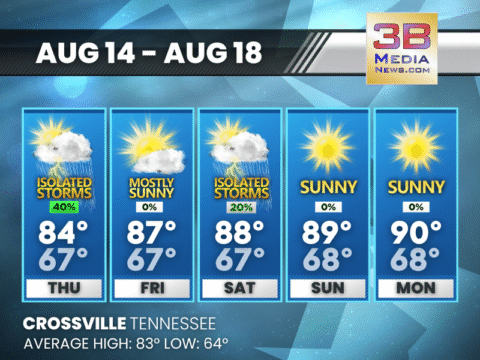
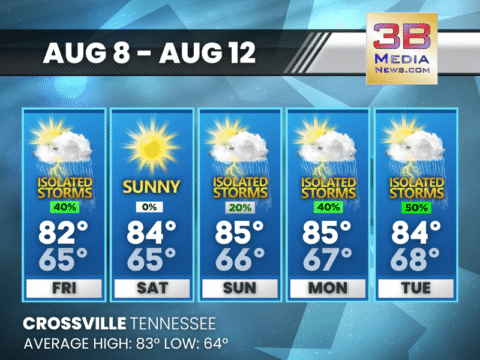
SHOWERS & STORMS POSSIBLE THURSDAY AFTERNOON; MOSTLY SUNNY FRIDAY
A warm stretch continues with occasional afternoon storms, patchy morning fog, and highs climbing near 90 by Monday. Thursday: A 40 percent chance of showers and

FLOOD WATCH IN EFFECT FOR PARTS OF THE CUMBERLAND PLATEAU
A Flood Watch is in effect from 6:00 a.m. to 7:00 p.m. CDT on Wednesday, August 13, 2025, for Cumberland, Pickett, and Fentress counties in

FLOOD WATCH IN EFFECT FOR MULTIPLE EAST TENNESSEE COUNTIES
A Flood Watch has been issued from 3:43 a.m. until 8:00 p.m. EDT on Wednesday, August 13, 2025 for the following counties in Tennessee: Blount,
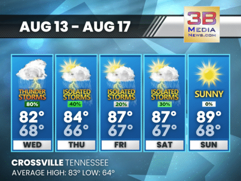
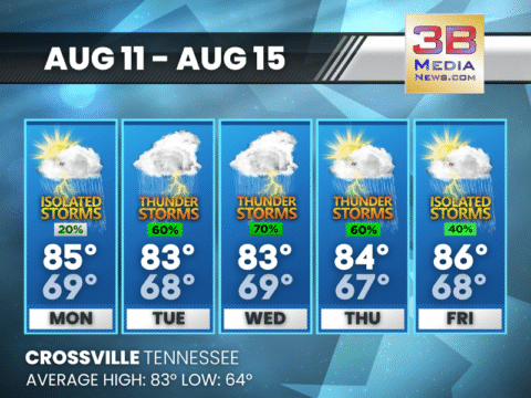
SHOWERS, STORMS, AND PATCHY FOG THROUGH MIDWEEK
Heavy rain and thunderstorms are likely Wednesday, with lingering showers, patchy fog, and a gradual return to sunshine by the weekend. Wednesday: Showers and thunderstorms likely

FLOOD ADVISORY IN EFFECT FOR SEVERAL LOCAL AREAS
The National Weather Service in Morristown, Tennessee, issued a Flood Advisory at 8:08 AM EDT on Tuesday, August 12, 2025, effective until 9:30 AM EDT,
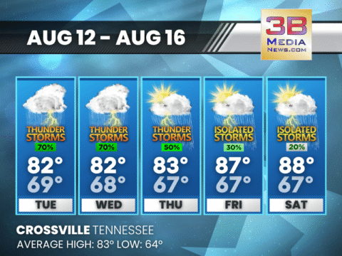
SHOWERS AND STORMS LIKELY THROUGH MIDWEEK
Periods of rain and thunderstorms are expected from Tuesday afternoon into Thursday, with some breaks in between and warmer, sunnier weather by the weekend. Tuesday: Showers
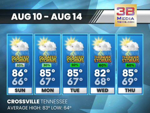
WARM AND HUMID WEEK AHEAD WITH DAILY THUNDERSTORM CHANCES
Expect warm afternoons near the mid-80s and scattered storms each day, with the best chances Tuesday through Thursday. Monday: A 20 percent chance of showers and
SUNSHINE STARTS THE WEEK, BUT STORMS GROW MORE LIKELY BY MIDWEEK
Expect mostly sunny skies Sunday and Monday before increasing storm chances bring wetter afternoons from Tuesday through Thursday. Sunday: A 20 percent chance of showers and
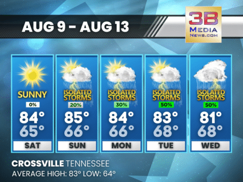
DRY WEEKEND BEFORE MIDWEEK RAIN CHANCES RETURN
Sunshine dominates through Sunday, but scattered showers and storms are expected to develop early next week, with the highest chances Tuesday and Wednesday. Saturday: Sunny, with
MOSTLY SUNNY WEEKEND AHEAD WITH SMALL RAIN CHANCES
Expect warm days and clear nights, with only a slight chance of showers and thunderstorms on Sunday. Today: A 40 percent chance of showers and thunderstorms,

SUNNY WEEKEND WITH FOGGY MORNINGS, STORMS BY MIDWEEK
Expect sunshine and calm winds through Tuesday, with patchy morning fog and a chance of midweek storms starting Wednesday. Saturday: Patchy fog before 8am. Otherwise, sunny, with a high near 89. Ca ...

SUNNY WEEKEND AHEAD WITH WARM TEMPERATURES
Foggy mornings will give way to sunny afternoons through Monday, with highs climbing into the upper 80s and low 90s. Friday: A 20 percent chance of showers and thunderstorms after 1pm. Patchy dense ...

SHOWERS & STORMS POSSIBLE THURSDAY AFTERNOON; MOSTLY SUNNY FRIDAY
A warm stretch continues with occasional afternoon storms, patchy morning fog, and highs climbing near 90 by Monday. Thursday: A 40 percent chance of showers and thunderstorms, mainly after 1pm. Pa ...

FLOOD WATCH IN EFFECT FOR PARTS OF THE CUMBERLAND PLATEAU
A Flood Watch is in effect from 6:00 a.m. to 7:00 p.m. CDT on Wednesday, August 13, 2025, for Cumberland, Pickett, and Fentress counties in Tennessee. Flooding caused by excessive rainfall is possible ...

FLOOD WATCH IN EFFECT FOR MULTIPLE EAST TENNESSEE COUNTIES
A Flood Watch has been issued from 3:43 a.m. until 8:00 p.m. EDT on Wednesday, August 13, 2025 for the following counties in Tennessee: Blount, Morgan, Rhea, Meigs, Monroe, Roane, Loudon, Bledsoe, And ...

SHOWERS, STORMS, AND PATCHY FOG THROUGH MIDWEEK
Heavy rain and thunderstorms are likely Wednesday, with lingering showers, patchy fog, and a gradual return to sunshine by the weekend. Wednesday: Showers and thunderstorms likely before 1pm, then ...

FLOOD ADVISORY IN EFFECT FOR SEVERAL LOCAL AREAS
The National Weather Service in Morristown, Tennessee, issued a Flood Advisory at 8:08 AM EDT on Tuesday, August 12, 2025, effective until 9:30 AM EDT, for parts of east Tennessee, specifically Anders ...

SHOWERS AND STORMS LIKELY THROUGH MIDWEEK
Periods of rain and thunderstorms are expected from Tuesday afternoon into Thursday, with some breaks in between and warmer, sunnier weather by the weekend. Tuesday: Showers and thunderstorms likel ...

WARM AND HUMID WEEK AHEAD WITH DAILY THUNDERSTORM CHANCES
Expect warm afternoons near the mid-80s and scattered storms each day, with the best chances Tuesday through Thursday. Monday: A 20 percent chance of showers and thunderstorms after 2pm. Patchy fog ...

SUNSHINE STARTS THE WEEK, BUT STORMS GROW MORE LIKELY BY MIDWEEK
Expect mostly sunny skies Sunday and Monday before increasing storm chances bring wetter afternoons from Tuesday through Thursday. Sunday: A 20 percent chance of showers and thunderstorms after 4pm ...

DRY WEEKEND BEFORE MIDWEEK RAIN CHANCES RETURN
Sunshine dominates through Sunday, but scattered showers and storms are expected to develop early next week, with the highest chances Tuesday and Wednesday. Saturday: Sunny, with a high near 84. Ca ...

MOSTLY SUNNY WEEKEND AHEAD WITH SMALL RAIN CHANCES
Expect warm days and clear nights, with only a slight chance of showers and thunderstorms on Sunday. Today: A 40 percent chance of showers and thunderstorms, mainly between 2pm and 4pm. Mostly sunn ...