
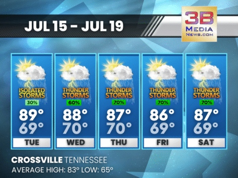
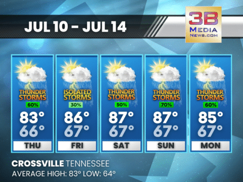
AFTERNOON STORMS RETURN MIDWEEK THROUGH SATURDAY
Expect increasing chances for afternoon and evening thunderstorms starting Wednesday, with the highest likelihood from Thursday through Saturday. Tuesday: A 30 percent chance of showers and
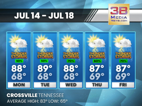
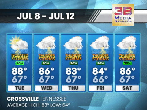
MIDWEEK STORMS GROW STRONGER AS HUMIDITY BUILDS
Daily storm chances linger through Friday, with increasing rain coverage mid to late week and highs staying in the upper 80s. Monday: A 50 percent chance
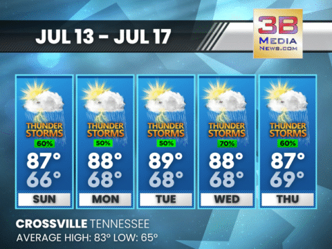
DAILY THUNDERSTORM CHANCES CONTINUE THROUGH THURSDAY
Scattered storms and patchy fog are expected each day, with highs near 87–89 and only brief breaks of sunshine between rain chances. Today: Showers and thunderstorms

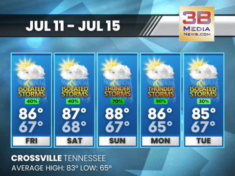
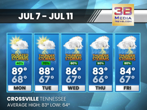
STORM CHANCES RAMP UP THROUGH MIDWEEK WITH DAILY THUNDERSTORMS
Scattered storms are likely each afternoon through Wednesday, with the greatest chances for rain on Sunday and midweek. Saturday: Showers and thunderstorms likely, mainly between 1pm
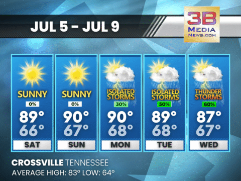
STORM CHANCES RETURN THIS WEEKEND WITH SUNSHINE IN BETWEEN
Friday and Saturday will be mostly sunny with isolated storms, but Sunday brings a greater risk for widespread thunderstorms. Friday: A 40 percent chance of showers
SHOWERS AND STORMS RETURN THURSDAY WITH MORE TO COME THIS WEEKEND
Scattered thunderstorms are likely Thursday afternoon with more chances each day through Monday, especially during the afternoon and evening hours. Thursday: Showers and thunderstorms likely, mainly

SHOWERS AND STORMS LIKELY THROUGH THE WEEK WITH PATCHY FOG AT NIGHT
Multiple rounds of showers and thunderstorms are expected each afternoon and evening through Sunday, with patchy fog developing during the overnight hours. Wednesday: A chance of
SHOWERS AND STORMS RETURN THROUGH MIDWEEK
Scattered thunderstorms develop this afternoon with more widespread activity expected Wednesday and Thursday. Today: A 40 percent chance of showers and thunderstorms, mainly after 1pm. Patchy

SPECIAL WEATHER STATEMENT ISSUED
Special Weather Statement issued July 7 at 2:29PM CDT by NWS Nashville TN July 7, 2025 at 2:30:29 PM CDT At 229 PM CDT, Doppler radar
STRONGER STORMS RETURN MIDWEEK WITH HEAVY RAIN POSSIBLE
After a quiet Monday, storm chances increase sharply from Tuesday through Friday, with the highest rain potential on Wednesday and Thursday. Monday: A 40 percent chance

HEAT BUILDS AS STORMS RETURN MIDWEEK
Sunny and calm Sunday and Monday give way to increasing storm chances Tuesday through Thursday, with highs in the upper 80s. Sunday: Mostly sunny, with a
SUNNY WEEKEND AHEAD BEFORE MIDWEEK STORMS RETURN
The weekend will stay sunny and seasonably warm, but scattered showers and storms are expected to return by Monday afternoon and become more widespread by

AFTERNOON STORMS RETURN MIDWEEK THROUGH SATURDAY
Expect increasing chances for afternoon and evening thunderstorms starting Wednesday, with the highest likelihood from Thursday through Saturday. Tuesday: A 30 percent chance of showers and thunder ...

MIDWEEK STORMS GROW STRONGER AS HUMIDITY BUILDS
Daily storm chances linger through Friday, with increasing rain coverage mid to late week and highs staying in the upper 80s. Monday: A 50 percent chance of showers and thunderstorms, mainly after ...

DAILY THUNDERSTORM CHANCES CONTINUE THROUGH THURSDAY
Scattered storms and patchy fog are expected each day, with highs near 87–89 and only brief breaks of sunshine between rain chances. Today: Showers and thunderstorms likely, mainly between 1pm and ...

STORM CHANCES RAMP UP THROUGH MIDWEEK WITH DAILY THUNDERSTORMS
Scattered storms are likely each afternoon through Wednesday, with the greatest chances for rain on Sunday and midweek. Saturday: Showers and thunderstorms likely, mainly between 1pm and 2pm. Mostl ...

STORM CHANCES RETURN THIS WEEKEND WITH SUNSHINE IN BETWEEN
Friday and Saturday will be mostly sunny with isolated storms, but Sunday brings a greater risk for widespread thunderstorms. Friday: A 40 percent chance of showers and thunderstorms, mainly betwee ...

SHOWERS AND STORMS RETURN THURSDAY WITH MORE TO COME THIS WEEKEND
Scattered thunderstorms are likely Thursday afternoon with more chances each day through Monday, especially during the afternoon and evening hours. Thursday: Showers and thunderstorms likely, mainl ...

SHOWERS AND STORMS LIKELY THROUGH THE WEEK WITH PATCHY FOG AT NIGHT
Multiple rounds of showers and thunderstorms are expected each afternoon and evening through Sunday, with patchy fog developing during the overnight hours. Wednesday: A chance of showers and thunde ...

SHOWERS AND STORMS RETURN THROUGH MIDWEEK
Scattered thunderstorms develop this afternoon with more widespread activity expected Wednesday and Thursday. Today: A 40 percent chance of showers and thunderstorms, mainly after 1pm. Patchy fog b ...

SPECIAL WEATHER STATEMENT ISSUED
Special Weather Statement issued July 7 at 2:29PM CDT by NWS Nashville TN July 7, 2025 at 2:30:29 PM CDT At 229 PM CDT, Doppler radar was tracking a strong thunderstorm 7 miles west of Rockwood, ...

STRONGER STORMS RETURN MIDWEEK WITH HEAVY RAIN POSSIBLE
After a quiet Monday, storm chances increase sharply from Tuesday through Friday, with the highest rain potential on Wednesday and Thursday. Monday: A 40 percent chance of showers and thunderstorms ...

HEAT BUILDS AS STORMS RETURN MIDWEEK
Sunny and calm Sunday and Monday give way to increasing storm chances Tuesday through Thursday, with highs in the upper 80s. Sunday: Mostly sunny, with a high near 89. Calm wind becoming west north ...

SUNNY WEEKEND AHEAD BEFORE MIDWEEK STORMS RETURN
The weekend will stay sunny and seasonably warm, but scattered showers and storms are expected to return by Monday afternoon and become more widespread by midweek. Today: Sunny, with a high near 89 ...