

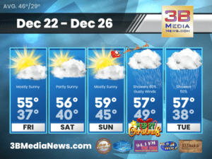
WINTER WEATHER ADVISORY
The National Weather Service has issued a Winter Weather Advisory for Cumberland County, Fentress County and Pickett County. This includes the cities of Byrdstown, Crossville
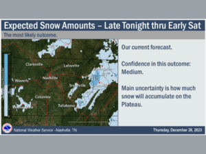
LIGHT SNOW POSSIBLE
The National Weather Service is expecting scattered light rain to start moving across Middle Tennessee later today. This off and on light rain will mix
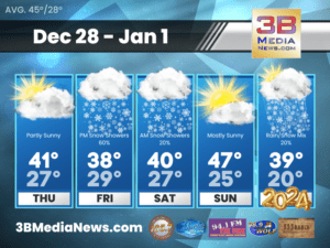
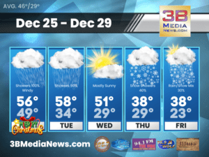
THURSDAY’S 5-DAY FORECAST
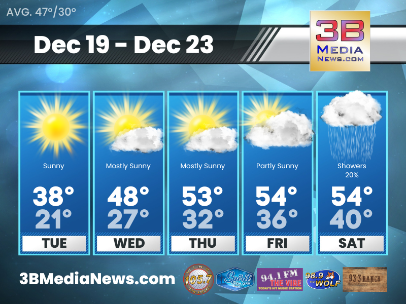
Thursday: Partly sunny, with a high near 41. West wind around 10 mph. Thursday Night: A 20 percent chance of snow showers. Mostly cloudy, with
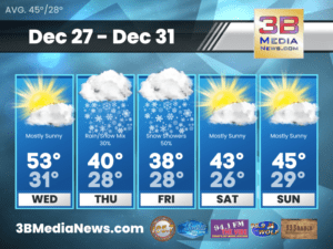
WEDNESDAY’S 5-DAY FORECAST
Showers will be possible on Thursday with locations along the plateau seeing a rain/snow mix or even all snow depending on the amount of dynamic
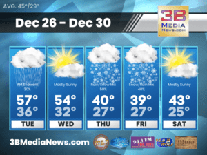
TUESDAY’S 5-DAY FORECAST
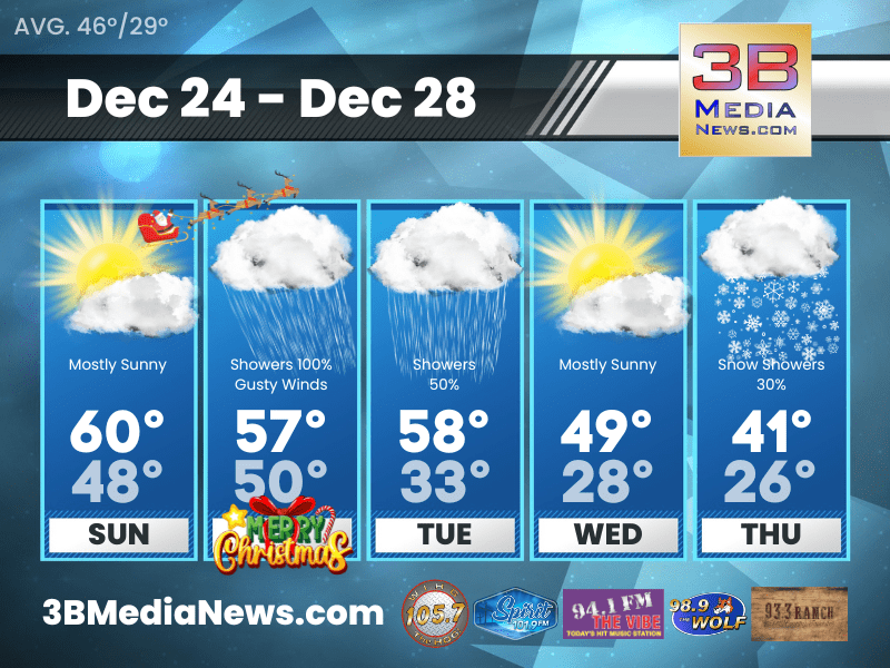
Tuesday: A 30 percent chance of showers, mainly before noon. Mostly cloudy, with a high near 57. West southwest wind around 5 mph becoming north
MONDAY’S 5-DAY FORECAST
It still appears widespread rain is on the way and will arrive late tonight and continue on into Christmas Day. Total rainfall amounts look like
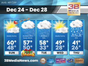
SUNDAY’S 5-DAY FORECAST
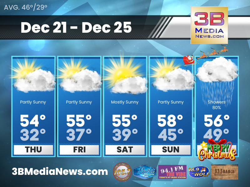
Widespread rainfall is on the way! The window for the heaviest rainfall looks like late Sunday night into Monday morning. Rainfall amounts of around three
Saturday’s 5-Day Forecast
Widespread showers and mild temperatures for Christmas Day. Saturday: Mostly sunny, with a high near 56. South wind 5 to 10 mph. Saturday Night: Partly
Friday’s 5-Day Forecast
Widespread showers and mild temperatures continue to look like the story for Christmas Day. Friday: Mostly sunny, with a high near 55. South wind around
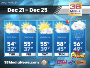
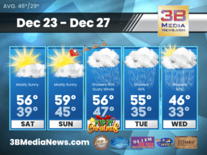
Thursday’s 5 Day Forecast
Thursday: Partly sunny, with a high near 54. Calm wind becoming south southeast around 5 mph. Thursday Night: Mostly cloudy, with a low around 32.
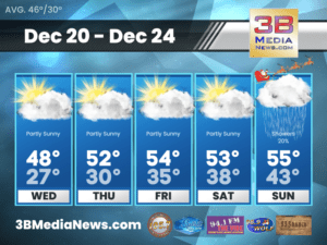
Wednesday’s 5-Day Forecast
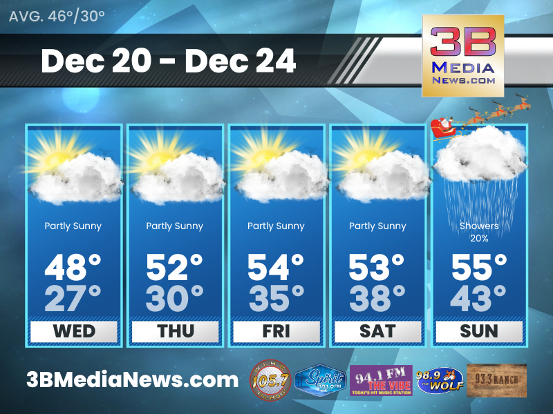
Most of this work week looks pretty quiet. Our next good shot at widespread rains will be on Christmas. That’s not ideal, but we need
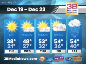
Tuesday’s 5-Day Forecast
Tuesday will be a much colder. Dry conditions will continue through at least Thursday. Tuesday: Sunny, with a high near 38. North wind around 5
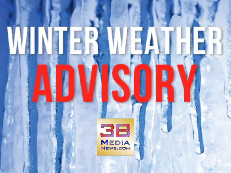
WINTER WEATHER ADVISORY
The National Weather Service has issued a Winter Weather Advisory for Cumberland County, Fentress County and Pickett County. This includes the cities of Byrdstown, Crossville and Jamestown. The Adviso ...

LIGHT SNOW POSSIBLE
The National Weather Service is expecting scattered light rain to start moving across Middle Tennessee later today. This off and on light rain will mix with some light snow tonight through Friday acro ...

THURSDAY’S 5-DAY FORECAST
Thursday: Partly sunny, with a high near 41. West wind around 10 mph. Thursday Night: A 20 percent chance of snow showers. Mostly cloudy, with a low around 27. West southwest wind around 10 mph. Fri ...

WEDNESDAY’S 5-DAY FORECAST
Showers will be possible on Thursday with locations along the plateau seeing a rain/snow mix or even all snow depending on the amount of dynamic cooling we can achieve. The surface cooling Thursday ni ...

TUESDAY’S 5-DAY FORECAST
Tuesday: A 30 percent chance of showers, mainly before noon. Mostly cloudy, with a high near 57. West southwest wind around 5 mph becoming north northwest in the afternoon. Tuesday Night: Mostly clou ...

MONDAY’S 5-DAY FORECAST
It still appears widespread rain is on the way and will arrive late tonight and continue on into Christmas Day. Total rainfall amounts look like three quarters of an inch up to 1 inch. The best chance ...
SUNDAY’S 5-DAY FORECAST
Widespread rainfall is on the way! The window for the heaviest rainfall looks like late Sunday night into Monday morning. Rainfall amounts of around three quarters of inch still look possible. Light s ...

Saturday’s 5-Day Forecast
Widespread showers and mild temperatures for Christmas Day. Saturday: Mostly sunny, with a high near 56. South wind 5 to 10 mph. Saturday Night: Partly cloudy, with a low around 39. South wind aroun ...

Friday’s 5-Day Forecast
Widespread showers and mild temperatures continue to look like the story for Christmas Day. Friday: Mostly sunny, with a high near 55. South wind around 5 mph. Friday Night: Partly cloudy, with a lo ...
Thursday’s 5 Day Forecast
Thursday: Partly sunny, with a high near 54. Calm wind becoming south southeast around 5 mph. Thursday Night: Mostly cloudy, with a low around 32. Calm wind becoming south around 5 mph after midnight ...
Wednesday’s 5-Day Forecast
Most of this work week looks pretty quiet. Our next good shot at widespread rains will be on Christmas. That's not ideal, but we need the rain. Wednesday: Partly sunny, with a high near 48. South sou ...
Tuesday’s 5-Day Forecast
Tuesday will be a much colder. Dry conditions will continue through at least Thursday. Tuesday: Sunny, with a high near 38. North wind around 5 mph. Tuesday Night: Partly cloudy, with a low around 2 ...