
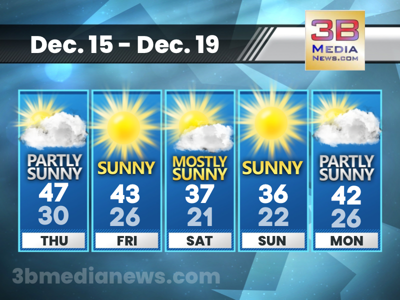
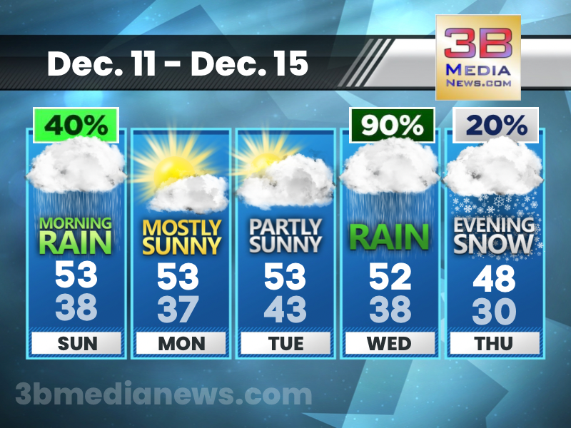
Thursday’s 5 Day Forecast
Partly sunny, with a high near 47. West southwest wind 5 to 10 mph. Source: National Weather Service — Nashville

RIVER FLOOD WARNING ISSUED FOR BLEDSOE COUNTY
River Flood Warning from Fri 12 am until 6 am CST Action Recommended: Avoid the subject event as per the instructions Issued By: Knoxville/Tri-Cities - TN, US, National Weather S ...

FLOOD WATCH FOR PORTION OF MIDDLE TENNESSEE
Nashville - TN, US, National Weather Service has issued a Flood Watch for a portion of Middle Tennessee, including the following counties, Cumberland, Putnam, and White. Description ...FLOOD WAT ...
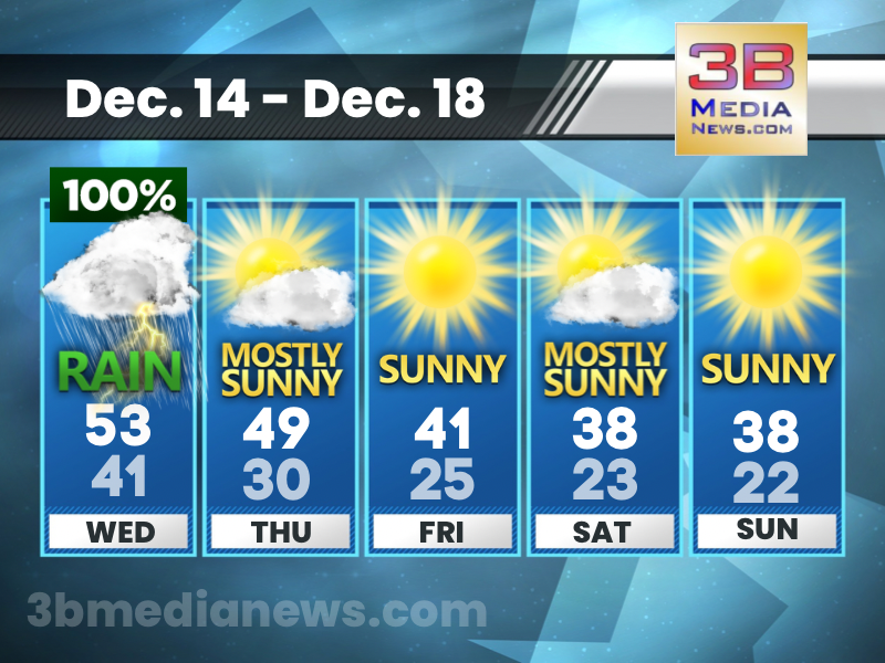
Wednesday’s 5 Day Forecast
Showers and thunderstorms are likely across our listening area on Wednesday. Highs are expected to reach the middle 50s with nighttime temperatures in the lower 40s. The eastern portions of our listen ...
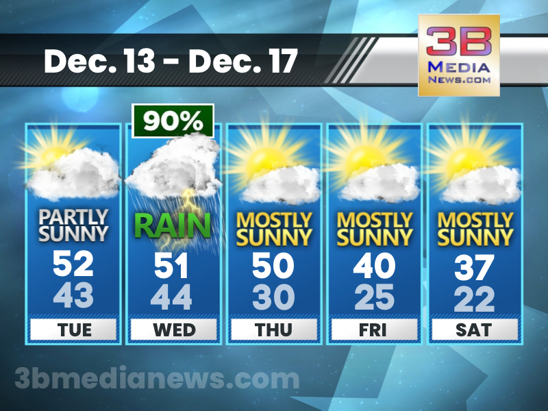
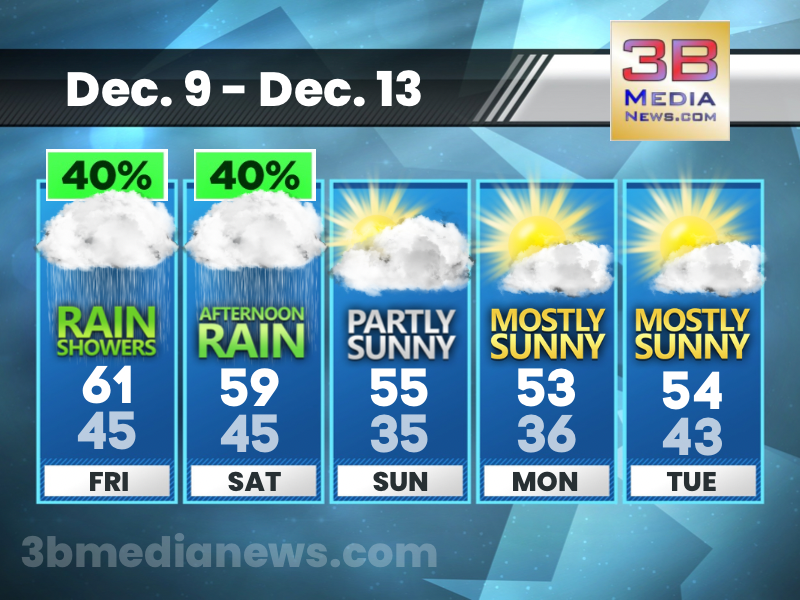
Tuesday’s 5 Day Forecast
It looks like our snow chances are gone this week, but there is another chance of snow showers next Monday.
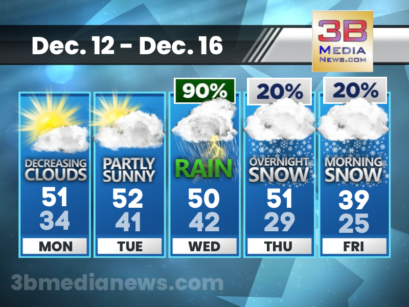
Monday’s 5 Day Forecast
Decreasing clouds today with a high near 51. Partly cloudy tonight with a low around 34. Sunshine and clouds on Tuesday with a high of 52. Showers, mainly after midnight Tuesday night with a low of 4 ...
Sunday’s 5 Day Forecast
Cloudy with a chance of showers, mainly before noon on Sunday with a high of 53 degrees in Crossville. Mostly cloudy Sunday night with a low around 38. We’ll finally see some sunshine Monday and Tuesd ...
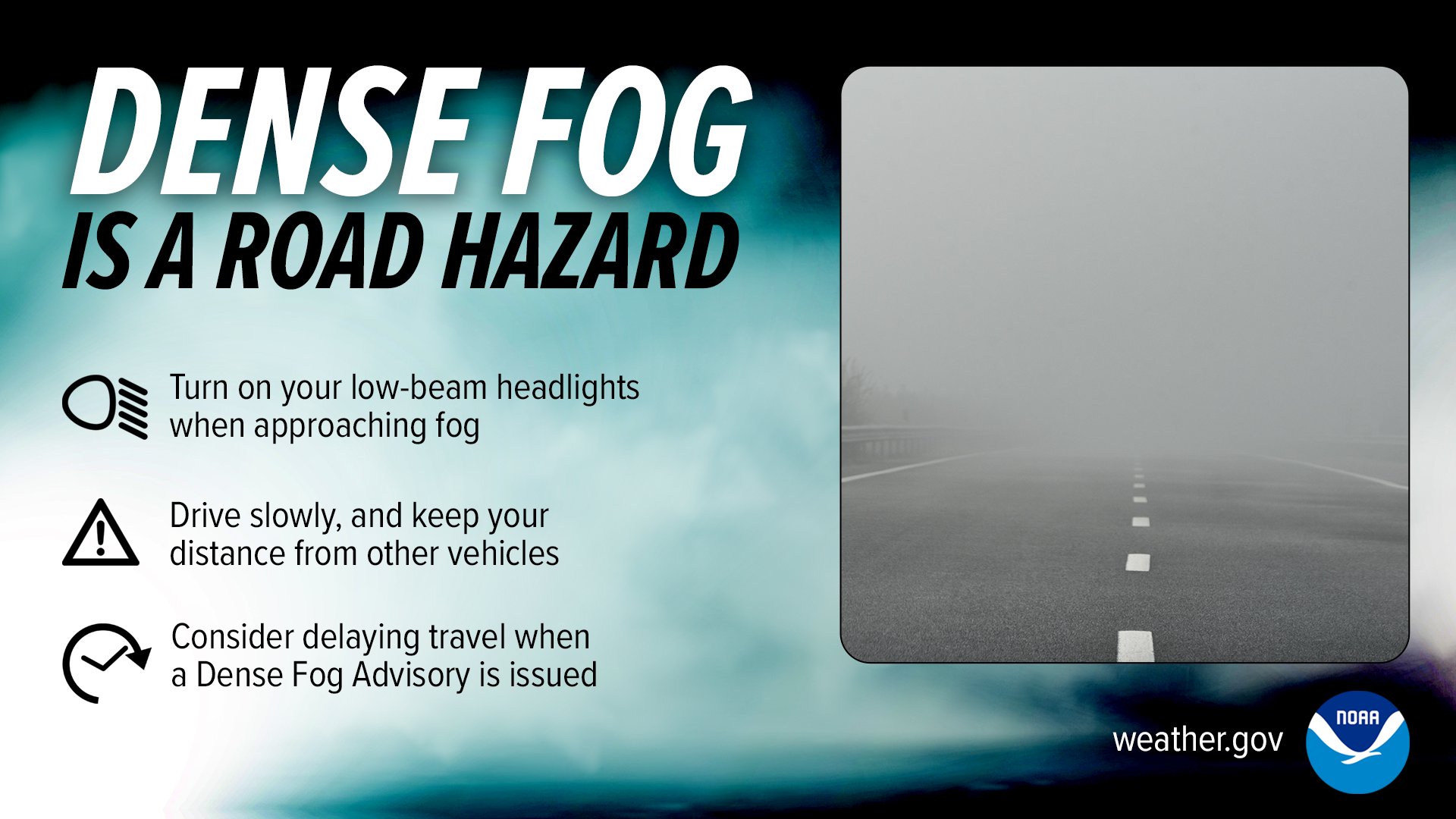
Dense Fog Advisory
Areas of dense fog have developed this evening and will continue through Saturday morning. A Dense Fog Advisory is in place across our listening area. Drive with caution and slow down. Be prepared for ...
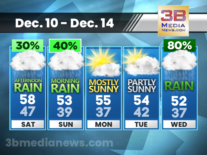
Saturday’s 5 Day Forecast
A 30 percent chance of showers, mainly after 2pm. Mostly cloudy, with a high near 58. Calm wind becoming west southwest around 5 mph.
Friday’s 5 Day Forecast
A 40 percent chance of showers, mainly before 3pm. Patchy fog before 7am. Otherwise, mostly cloudy, with a high near 61. Calm wind becoming south around 5 mph.
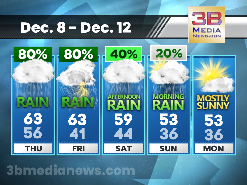
Thursday’s 5 Day Forecast
Showers. High near 63. Calm wind becoming south southeast around 5 mph in the afternoon. Chance of precipitation is 80%. New precipitation amounts between a quarter and half of an inch possible.
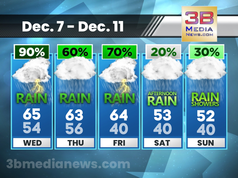
Wednesday’s 5 Day Forecast
Showers and possibly a thunderstorm. High near 65. Southwest wind 5 to 10 mph. Chance of precipitation is 90%. New rainfall amounts between a half and three quarters of an inch possible.