
COLD EARLY, SPRING WARMTH SURGES BY THE WEEKEND
A chilly, mostly sunny Tuesday is followed by clouds midweek and a steady warm-up into the 70s by the weekend.
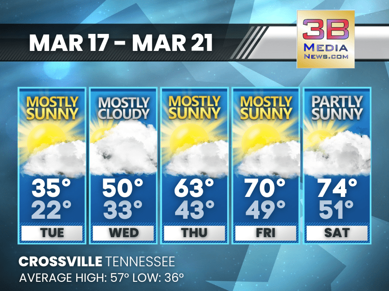
Tuesday: Mostly sunny, with a high near 35. West wind around 10 mph, with gusts as high as 25 mph.
Tuesday Night: Mostly cloudy, with a low around 22. West northwest wind around 5 mph becoming calm.
Wednesday: Mostly cloudy, with a high near 50. South southwest wind 5 to 10 mph, with gusts as high as 20 mph.
Wednesday Night: Mostly clear, with a low around 33. South southwest wind around 5 mph.
Thursday: Mostly sunny, with a high near 63. West southwest wind around 5 mph.
Thursday Night: Mostly clear, with a low around 43. Calm wind.
Friday: Mostly sunny, with a high near 70. Calm wind becoming west southwest around 5 mph in the morning.
Friday Night: Partly cloudy, with a low around 49.
Saturday: Partly sunny, with a high near 74.
Saturday Night: Partly cloudy, with a low around 51.
Almanac for Crossville, Tennessee for March 17
- Normal High Temperature: 57
- Normal Low Temperature: 36
- Record High Temperature: 76 in 1982
- Record Low Temperature: 18 in 1988
- Record Rainfall: 3.69 in 2002
- Record Snowfall: 3.0 in 1978
- Sunrise: 6:48 AM CDT
- Sunset: 6:50 PM CDT
- Spring Equinox: Friday, March 20, 2026 at 9:46 AM CST
- Next Full Moon: Wednesday, April 1, 2026 at 9:12 PM CST (known as the Pink Moon)
- Daylight Saving Time Ends: Sunday, November 1, 2026 at 2:00 AM CDT
Weather information is provided by the National Weather Service in Nashville and Morristown. You can hear the latest forecast on 105.7 The Hog, 94.1 The Vibe (1410 AM), Spirit 101.9, 98.9 The Wolf, and 93.3 The Ranch (580 AM). Stay connected with Weather Reporter Johnny Caudle on social media by following him on Facebook, X, Instagram, Bluesky, and YouTube. You can also click here to send him an email.