
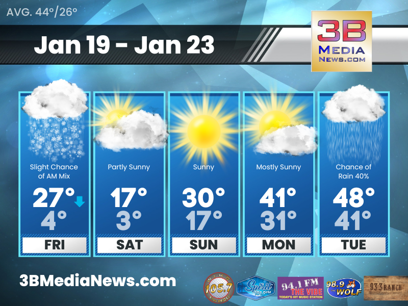
FRIDAY’S 5-DAY FORECAST
Arctic air will give us a very cold weekend with temperatures falling into the single digits on Saturday morning and highs only reach the teens for most locations by Saturday afternoon.
Friday: A slight chance of snow and freezing rain before 8am, then a slight chance of snow between 8am and 10am. Mostly cloudy, with a temperature rising to near 27 by 8am, then falling to around 17 during the remainder of the day. West northwest wind around 15 mph, with gusts as high as 25 mph. Chance of precipitation is 20%.
Friday Night: Mostly cloudy, with a low around 4. Wind chill values as low as -11. Northwest wind 10 to 15 mph, with gusts as high as 20 mph.
Saturday: Partly sunny, with a high near 17. North northwest wind around 10 mph.
Saturday Night: Mostly clear, with a low around 3. North wind 5 to 10 mph.
Sunday: Sunny, with a high near 30. Northeast wind 5 to 10 mph becoming east southeast in the afternoon.
Sunday Night: Partly cloudy, with a low around 17. South southeast wind 5 to 10 mph.
Monday: Mostly sunny, with a high near 41. South wind around 10 mph.
Monday Night: A 20 percent chance of rain after midnight. Mostly cloudy, with a low around 31.
Tuesday: A 40 percent chance of rain. Mostly cloudy, with a high near 48.
Tuesday Night: A 50 percent chance of rain. Cloudy, with a low around 41.
Source: National Weather Service Weather Forecast Offices in Nashville and Morristown.
Johnny Caudle has the latest weather forecast every hour on 105.7 The Hog, 94.1 The Vibe, Spirit 101.9, 98.9 The Wolf, and 93.3 The Ranch. Connect with Johnny Caudle on social media. Follow him on Facebook, X, Instagram and Threads. Send email to [email protected].