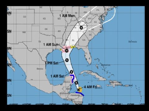
GULF COAST PREPARING FOR WHAT COULD BE HURRICANE NATE
Tropical Storm Nate roared toward Mexico’s Yucatan Peninsula after drenching Central America in rain that was blamed for at least 22 deaths, and forecasters said it could reach the U.S. Gulf Coast as a hurricane over the weekend.
Louisiana officials declared a state of emergency and ordered some people to evacuate coastal areas and barrier islands ahead of its expected landfall early Sunday, and evacuations began at some offshore oil platforms in the Gulf.
A hurricane watch was in effect for Morgan City Louisiana to the Mississippi/Alabama border and for the New Orleans area.
The U.S. National Hurricane Center said Nate could dump 3 to 6 inches of rain on U.S. central Gulf Coast states, with as much as a foot in some places.
Before that, the center said, Nate could cause dangerous flooding by dumping as much as 15 to 20 inches of rain as it moved over Honduras, with higher accumulations in a few places.
It had maximum sustained winds of 45 mph by Friday morning and was likely to strengthen over the northwestern Caribbean Sea on Friday before a possible strike on the Cancun region at the tip of Mexico’s Yucatan Peninsula at near-hurricane strength. It could hit the U.S. Gulf coast near New Orleans.
Early Friday, the storm was centered about 230 miles south-southeast of Cozumel, Mexico, and was moving north-northwest at 14 mph.
Officials ordered the evacuation of part of coastal St. Bernard Parish east of New Orleans ahead of the storm. Earlier Thursday, a voluntary evacuation was called in the barrier island town of Grand Isle south of New Orleans.
New Orleans officials outlined steps to bolster the city’s pump and drainage system. Weaknesses in that system were revealed during summer flash floods.
The Bureau of Safety and Environmental Enforcement’s New Orleans office said in a news release that as of midday Thursday, six production platforms, out of the 737 manned platforms in the Gulf, had been evacuated. No drilling rigs were evacuated, but one moveable rig was taken out of the storm’s path.
The agency estimated less than 15 percent of the current oil production in the Gulf of Mexico has been shut-in, which equates to 254,607 barrels of oil per day.
Once the storm comes inland, the current track for Nate calls for it to speed up and enter eastern Tennessee and Kentucky late Sunday night as a tropical depression. Early projections call for the remains of Nate to bring anywhere from 3 to 5 inches of rain to eastern Tennessee and Kentucky as well as winds gusting up to 30 mph at times.


