
MIDWEEK MILD SPELL BEFORE SHOWERS RETURN
Temperatures trend milder through midweek with some sunshine before isolated showers develop late in the week.
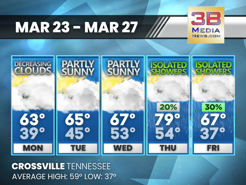
Monday: Cloudy through mid morning, then gradual clearing, with a high near 63. North northeast wind around 10 mph, with gusts as high as 25 mph.
Monday Night: Increasing clouds, with a low around 39. North northeast wind around 5 mph.
Tuesday: Partly sunny, with a high near 65. East wind around 5 mph becoming south in the afternoon.
Tuesday Night: Mostly cloudy, with a low around 45. South wind around 5 mph.
Wednesday: Partly sunny, with a high near 67. South wind 5 to 10 mph, with gusts as high as 20 mph.
Wednesday Night: Mostly cloudy, with a low around 53. South wind around 5 mph.
Thursday: A 20 percent chance of showers before 1pm. Partly sunny, with a high near 79. Southwest wind 5 to 10 mph, with gusts as high as 20 mph.
Thursday Night: A 20 percent chance of showers after 1am. Mostly clear, with a low around 54.
Friday: A 30 percent chance of showers. Partly sunny, with a high near 67.
Friday Night: A 20 percent chance of showers. Mostly cloudy, with a low around 37.
Almanac for Crossville, Tennessee for March 23
- Normal High Temperature: 59
- Normal Low Temperature: 37
- Record High Temperature: 77 in 2007
- Record Low Temperature: 16 in 1960
- Record Rainfall: 2.54 in 1993
- Record Snowfall: 1.0 in 1968
- Sunrise: 6:40 AM CDT
- Sunset: 6:55 PM CDT
- Next Full Moon: Wednesday, April 1, 2026 at 9:12 PM CST (known as the Pink Moon)
- Spring Solstice: Sunday, June 21, 2026 at 3:24 AM CST
- Daylight Saving Time Ends: Sunday, November 1, 2026 at 2:00 AM CDT
Weather information is provided by the National Weather Service in Nashville and Morristown. You can hear the latest forecast on 105.7 The Hog, 94.1 The Vibe (1410 AM), Spirit 101.9, 98.9 The Wolf, and 93.3 The Ranch (580 AM). Stay connected with Weather Reporter Johnny Caudle on social media by following him on Facebook, X, Instagram, Bluesky, and YouTube. You can also click here to send him an email.