
MONDAY’S 5 DAY FORECAST
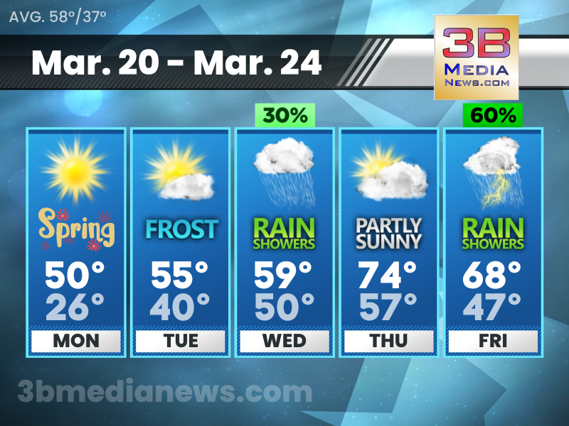
Monday will bring sunshine and the start of a warming trend, although it will still be several degrees cooler than normal. Spring will begin Monday at 4:24 PM CDT. A Freeze Watch is in effect from late Monday night through Tuesday morning.
Monday: Widespread frost before 8am. Otherwise, sunny, with a high near 50. Calm wind becoming east southeast around 5 mph.
Monday Night: Areas of frost after 1am. Otherwise, partly cloudy, with a low around 26. West southwest wind around 5 mph becoming south southeast in the evening.
Tuesday: Areas of frost before 8am. Otherwise, mostly sunny, with a high near 55. South wind 5 to 10 mph.
Tuesday Night: A 30 percent chance of showers after 1am. Mostly cloudy, with a low around 40. South wind 10 to 15 mph, with gusts as high as 25 mph.
Wednesday: A 30 percent chance of showers before 1pm. Mostly cloudy, with a high near 59. South wind 10 to 15 mph, with gusts as high as 20 mph.
Wednesday Night: Mostly cloudy, with a low around 50. South wind 10 to 15 mph.
Thursday: Partly sunny, with a high near 74. South southwest wind 10 to 15 mph, with gusts as high as 25 mph.
Thursday Night: A 20 percent chance of showers after 1am. Partly cloudy, with a low around 57.
Friday: Showers likely and possibly a thunderstorm. Mostly cloudy, with a high near 68. Chance of precipitation is 60 percent.
Friday Night: Showers likely. Mostly cloudy, with a low around 47. Chance of precipitation is 60 percent.
Source – National Weather Service – Nashville & Morristown
Connect with Weathercaster Johnny Caudle on social media. Follow him on Facebook, Twitter, and Instagram. Send email to [email protected].