
SATURDAY AFTERNOON WINTER STORM UPDATE FROM NATIONAL WEATHER SERVICE-NASHVILLE
SATURDAY AFTERNOON WINTER STORM UPDATE: To say this is a difficult forecast is the understatement of the year, and it’s January. Please read carefully!
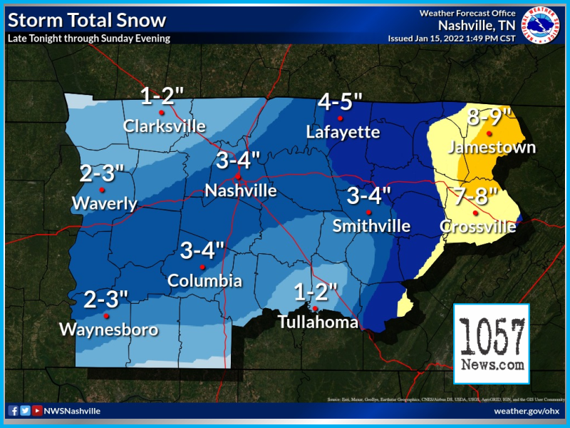
What makes this forecast so difficult? Weather models show that not only the surface will be around freezing, but the lowest 3000 feet of the atmosphere will be around freezing as well for most of the event. This means that ANY portion of that 3000 feet can be a degree or two warmer or colder, and snowfall amounts will be drastically different. If we stay cooler by just a degree or two for a longer duration, heavy snow will be a slam dunk. If we stay warmer, rain and a rain snow mix will rob the moisture and we’re left with little to no snow accumulation. This can occur anywhere across the mid state as there’s bound to be warm and cold pockets during the event.
Right now, it looks like the Plateau will get the higher accumulations since they will be at a higher elevation, and are more likely to cool a bit faster and stay at or below freezing Sunday. Snow amounts of 5 to 10 inches will be possible on the Plateau. Other higher elevation locations west of the Plateau will also have better chances at higher snow totals as well of around 3 to 6 inches. Elsewhere across the mid state, we have around 2 to 5 inches of snow in our forecast, which will be HIGHLY dependent on those temperatures in the lowest 3000 feet of the atmosphere (especially the surface). Variations of just a degree or two either way will have the potential to drastically change the forecast.
Regardless of snow amounts, any snow received or even a rain snow mix will be hazardous to travel. Temps will cool Sunday night into Monday, and will likely keep travel difficult through the day Monday as we remain cloudy with temps mainly in the 30s. Please stay tuned for any additional updates to the forecast!