
SATURDAY’S 5 DAY FORECAST
A Wind Advisory is in effect until 1 PM CDT Saturday for the Cumberland Plateau and until 8 PM EDT Saturday for the Tennessee Valley.
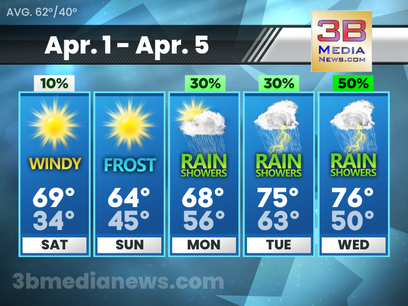
Saturday: A 10 percent chance of showers before 7am. Sunny, with a high near 69. Windy, with a west southwest wind 15 to 20 mph increasing to 20 to 25 mph in the afternoon. Winds could gust as high as 45 mph.
Saturday Night: Areas of frost after 3am. Otherwise, mostly clear, with a low around 34. Northwest wind 15 to 20 mph decreasing to 5 to 10 mph after midnight. Winds could gust as high as 30 mph.
Sunday: Widespread frost, mainly between 7am and 8am. Otherwise, sunny, with a high near 64. North wind around 5 mph becoming south southwest in the afternoon.
Sunday Night: Partly cloudy, with a low around 45. South wind 5 to 10 mph.
Monday: A 30 percent chance of showers, mainly before 1pm. Partly sunny, with a high near 66. South wind 10 to 15 mph, with gusts as high as 25 mph.
Monday Night: A 20 percent chance of showers and thunderstorms after 1am. Mostly cloudy, with a low around 56. South wind around 15 mph, with gusts as high as 20 mph.
Tuesday: A slight chance of showers, then a chance of showers and thunderstorms after 1pm. Mostly cloudy, with a high near 75. South wind around 15 mph, with gusts as high as 20 mph. Chance of precipitation is 30%.
Tuesday Night: A 40 percent chance of showers and thunderstorms. Mostly cloudy, with a low around 63. South wind around 15 mph, with gusts as high as 20 mph.
Wednesday: A 50 percent chance of showers and thunderstorms. Mostly cloudy, with a high near 76.
Wednesday Night: A 50 percent chance of showers and thunderstorms. Mostly cloudy, with a low around 50.
Source – National Weather Service – Nashville & Morristown
Connect with Forecaster Johnny Caudle on social media. Follow him on Facebook, Twitter, and Instagram. Send email to [email protected].