
Saturday’s 5-Day Forecast
Dry and unseasonably warm with near record high temperatures on Sunday in some locations. Light rain is possible Sunday night into Monday. A significant cooldown is expected Tuesday through Wednesday.
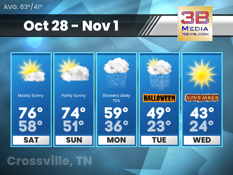
Saturday: Mostly sunny, with a high near 76. South southwest wind around 5 mph.
Saturday Night: Mostly cloudy, with a low around 58. South wind around 5 mph.
Sunday: Partly sunny, with a high near 74. Southwest wind 5 to 10 mph.
Sunday Night: A 30 percent chance of showers after 2am. Mostly cloudy, with a low around 51. Southwest wind around 5 mph.
Monday: Showers likely, mainly after 8am. Mostly cloudy, with a high near 59. West wind 10 to 15 mph becoming north northwest in the afternoon. Winds could gust as high as 20 mph. Chance of precipitation is 70%.
Monday Night: Showers likely, mainly before 8pm. Cloudy, with a low around 36. North wind 10 to 15 mph, with gusts as high as 20 mph. Chance of precipitation is 70%.
Tuesday: A 20 percent chance of showers. Partly sunny, with a high near 49. North wind around 10 mph.
Tuesday Night: A 20 percent chance of showers before 8pm. Partly cloudy, with a low around 23. North northwest wind around 15 mph, with gusts as high as 25 mph.
Wednesday: Sunny, with a high near 43.
Wednesday Night: Widespread frost. Otherwise, mostly clear, with a low around 24.
Source: National Weather Service Weather Forecast Offices in Nashville and Morristown.
Forecaster Johnny Caudle has the latest weather forecast every hour on 105.7 The Hog, 94.1 The Vibe, Spirit 101.9, 98.9 The Wolf, and 93.3 The Ranch. Connect with Johnny Caudle on social media. Follow him on Facebook, X, Instagram and Threads. Send email to [email protected].