
SEVERE STORMS POSSIBLE FRIDAY AND SATURDAY
There is a medium to high chance of thunderstorms Friday afternoon and evening across all of Middle Tennessee, which is currently under a slight risk (level 2 out of 5) for severe weather. The primary concern on Friday is damaging winds. Storm chances remain elevated into Saturday, with the greatest risk for severe weather concentrated south of I-40. The main threats both days include damaging winds and hail potentially up to the size of golf balls. The most likely time for severe storms to occur is between 3 PM and 9 PM.
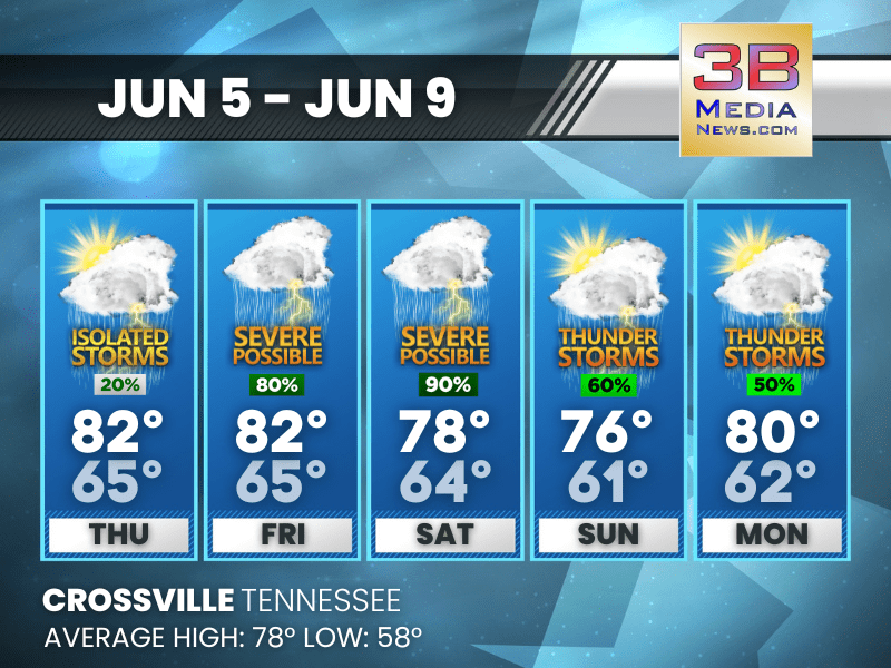
Thursday: A 20 percent chance of showers and thunderstorms after 1pm. Mostly sunny, with a high near 82. Calm wind becoming south around 5 mph.
Thursday Night: A 20 percent chance of showers and thunderstorms before 11pm. Partly cloudy, with a low around 65. Calm wind.
Friday: Showers and thunderstorms likely, then showers and possibly a thunderstorm after 3pm. High near 82. Calm wind becoming west around 5 mph in the morning. Chance of precipitation is 80%.
Friday Night: Showers and thunderstorms likely before 10pm, then showers likely and possibly a thunderstorm after 10pm. Mostly cloudy, with a low around 65. West southwest wind around 5 mph. Chance of precipitation is 70%.
Saturday: A chance of showers and thunderstorms, then showers and possibly a thunderstorm after 1pm. High near 78. West wind 5 to 10 mph, with gusts as high as 20 mph. Chance of precipitation is 90%.
Saturday Night: Showers likely and possibly a thunderstorm before 7pm, then showers and thunderstorms likely between 7pm and 10pm, then showers likely and possibly a thunderstorm after 10pm. Mostly cloudy, with a low around 64. West southwest wind around 5 mph. Chance of precipitation is 70%.
Sunday: Showers likely and possibly a thunderstorm before 1pm, then a chance of showers and thunderstorms after 1pm. Partly sunny, with a high near 76. West wind 5 to 10 mph. Chance of precipitation is 60%.
Sunday Night: Mostly clear, with a low around 61. West wind around 5 mph becoming calm.
Monday: A slight chance of showers, then a chance of showers and thunderstorms after 1pm. Mostly sunny, with a high near 80. Chance of precipitation is 50%.
Monday Night: Showers and thunderstorms likely. Mostly cloudy, with a low around 62. Chance of precipitation is 60%.
Almanac for Crossville, Tennessee for June 5, 2025:
- Normal High Temperature: 78
- Normal Low Temperature: 58
- Record High Temperature: 89 in 2011
- Record Low Temperature: 40 in 1954
- Sunrise: 5:24 AM CDT
- Sunset: 7:54 PM CDT
- Next Full Moon: Friday, June 11, 2025 at 2:44 AM CDT (known as the Strawberry Moon)
- Summer Solstice: Friday, June 20, 2025 at 9:42 PM CDT
Weather information is provided by the National Weather Service in Nashville and Morristown. Hear the latest forecast on 105.7 The Hog, 94.1 The Vibe (1410 AM), Spirit 101.9, 98.9 The Wolf, and 93.3 The Ranch (580 AM). Get connected with Weathercaster Johnny Caudle on social media. Follow him on Facebook, X, Instagram, Bluesky, and Threads. Click here to send him an email.