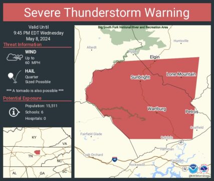
SEVERE THUNDERSTORM WARNING
BULLETIN – IMMEDIATE BROADCAST REQUESTED
Severe Thunderstorm Warning
National Weather Service Morristown TN
858 PM EDT Wed May 8 2024
The National Weather Service in Morristown has issued a
* Severe Thunderstorm Warning for…
Morgan County in east Tennessee…
Southwestern Scott County in east Tennessee…
* Until 945 PM EDT.
* At 857 PM EDT, a severe thunderstorm was located 12 miles northwest
of Fairfield Glade, or 13 miles north of Crossville, moving east at
45 mph.
HAZARD…60 mph wind gusts and quarter size hail.
SOURCE…Radar indicated.
IMPACT…Hail damage to vehicles is expected. Expect wind damage
to roofs, siding, and trees.
* Locations impacted include…
Wartburg, Sunbright, Oakdale, High Point, Coalfield, Deerlodge,
Elgin, Frozen Head State Park, Slick Rock, and Petros.
PRECAUTIONARY/PREPAREDNESS ACTIONS…
Remain alert for a possible tornado! Tornadoes can develop quickly
from severe thunderstorms. If you spot a tornado go at once into the
basement or small central room in a sturdy structure.
For your protection move to an interior room on the lowest floor of a
building.
A Tornado Watch remains in effect until midnight EDT for east
Tennessee.
&&
LAT…LON 3624 8488 3628 8488 3629 8487 3630 8480
3633 8477 3635 8441 3617 8443 3615 8445
3613 8443 3599 8444 3599 8472 3606 8479
3609 8480 3609 8483 3614 8487 3616 8491
3621 8491
TIME…MOT…LOC 0057Z 266DEG 41KT 3615 8500
TORNADO…POSSIBLE
HAIL THREAT…RADAR INDICATED
MAX HAIL SIZE…1.00 IN
WIND THREAT…RADAR INDICATED
MAX WIND GUST…60 MPH