TORNADO WARNING
BULLETIN – EAS ACTIVATION REQUESTED
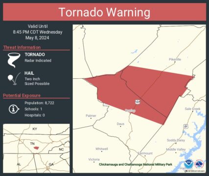
Tornado Warning
National Weather Service Morristown TN
804 PM CDT Wed May 8 2024
The National Weather Service in Morristown has issued a
* Tornado Warning for…
Northern Sequatchie County in east Tennessee…
Southwestern Bledsoe County in east Tennessee…
* Until 845 PM CDT.
* At 804 PM CDT, a severe thunderstorm capable of producing a tornado
was located 9 miles southeast of McMinnville, moving east at 25
mph.
HAZARD…Tornado and hail up to two inches in diameter.
SOURCE…Radar indicated rotation.
IMPACT…Flying debris will be dangerous to those caught without
shelter. Mobile homes will be damaged or destroyed.
Damage to roofs, windows, and vehicles will occur. Tree
damage is likely.
* This tornadic thunderstorm will remain over mainly rural areas of
northern Sequatchie and southwestern Bledsoe Counties, including
the following locations… Brayton, Palio, Old Cumberland, Cagle,
and Flat Top Mountain.
PRECAUTIONARY/PREPAREDNESS ACTIONS…
TAKE COVER NOW! Move to a basement or an interior room on the lowest
floor of a sturdy building. Avoid windows. If you are outdoors, in a
mobile home, or in a vehicle, move to the closest substantial shelter
and protect yourself from flying debris.
Tornadoes are extremely difficult to see and confirm at night. Do not
wait to see or hear the tornado. TAKE COVER NOW!
&&
LAT…LON 3553 8560 3555 8550 3555 8546 3559 8540
3554 8510 3551 8513 3549 8514 3549 8513
3545 8516 3545 8517 3532 8524 3542 8551
3544 8554 3549 8554
TIME…MOT…LOC 0104Z 290DEG 21KT 3558 8568
TORNADO…RADAR INDICATED
MAX HAIL SIZE…2.00 IN