
STORMY START, SUMMER FINISH
Unsettled weather through Friday with thunderstorms likely — calmer, warmer pattern takes hold by the weekend.
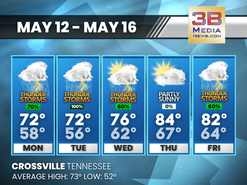
Monday: Showers likely and possibly a thunderstorm before 9am, then a chance of showers and thunderstorms after 9am. Cloudy, then gradually becoming mostly sunny, with a high near 72. South southeast wind 5 to 10 mph, with gusts as high as 20 mph. Chance of precipitation is 70%. New rainfall amounts between a quarter and half of an inch possible.
Monday Night: Showers and thunderstorms likely before 4am, then a chance of showers. Mostly cloudy, with a low around 58. South southeast wind around 5 mph. Chance of precipitation is 60%. New rainfall amounts between a tenth and quarter of an inch, except higher amounts possible in thunderstorms.
Tuesday: Showers, with thunderstorms also possible after 7am. High near 72. South wind around 5 mph. Chance of precipitation is 100%.
Tuesday Night: A chance of showers and thunderstorms. Mostly cloudy, with a low around 56. Calm wind. Chance of precipitation is 30%.
Wednesday: A chance of showers before 10am, then a chance of showers and thunderstorms between 10am and 1pm, then showers likely and possibly a thunderstorm after 1pm. Partly sunny, with a high near 76. Calm wind becoming south southwest around 5 mph in the morning. Chance of precipitation is 60%.
Wednesday Night: Partly cloudy, with a low around 62. South wind around 5 mph.
Thursday: Partly sunny, with a high near 84. South wind 5 to 10 mph, with gusts as high as 20 mph.
Thursday Night: A 30 percent chance of showers and thunderstorms after 1am. Mostly cloudy, with a low around 67. Southwest wind around 5 mph.
Friday: A chance of showers and thunderstorms, then showers likely and possibly a thunderstorm after 1pm. Mostly cloudy, with a high near 82. Chance of precipitation is 60%.
Friday Night: Showers and thunderstorms likely. Mostly cloudy, with a low around 64. Chance of precipitation is 70%.
Almanac for Crossville, Tennessee for May 12, 2025:
- Normal High Temperature: 73
- Normal Low Temperature: 52
- Record High Temperature: 86 in 1962
- Record Low Temperature: 35 in 1954
- Sunrise: 5:37 AM CDT
- Sunset: 7:37 PM CDT
- Next Full Moon: Monday, May 12, 2025 at 11:56 AM CDT (known as the Flower Moon)
- Summer Solstice: Friday, June 20, 2025 at 9:42 PM CDT
Weather information is provided by the National Weather Service in Nashville and Morristown. Hear the latest forecast on 105.7 The Hog, 94.1 The Vibe (1410 AM), Spirit 101.9, 98.9 The Wolf, and 93.3 The Ranch (580 AM). Get connected with Weathercaster Johnny Caudle on social media. Follow him on Facebook, X, Instagram, Bluesky, and Threads. Click here to send him an email.