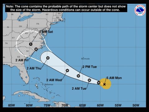
STRENGTHENING HURRICANE FLORENCE TAKING AIM AT THE CAROLINAS
Government officials from the Carolinas to the Mid-Atlantic today were preparing for a possible direct strike from Hurricane Florence later in the week, as the Category 2 storm continues to gain strength over the Atlantic, 625 miles southeast of Bermuda.
The National Hurricane Center warned a hurricane hunter plane found the storm strengthening quickly.
The Miami-based center said in its 5 a.m. ET advisory that Florence was moving west northwest at 9 mph. An increase in forward speed is expected over the next couple of days.
Its maximum sustained winds are at 105 mph. Drawing energy from the warm water, the now Category 2 storm could be a fearsome Category 4 with winds of 130 mph or more by tomorrow. Florence is expected to remain an extremely dangerous major hurricane through Thursday.
Officials fear a major storm surge on the coast and prolonged heavy rainfall. Large swells are expected to pound Bermuda and the U.S.’s East Coast.
“Somebody is going to suffer devastating damage if this storms continues as it is currently forecast,” Dan Miller, a meteorologist with the National Weather Service in Columbia, told The State newspaper.
Forecasters said it is too early to know the exact path Florence will take but warned that it could roll ashore in the Carolinas by Thursday. Governors of North and South Carolina and Virginia declared states of emergency far ahead of the approaching storm.
Navy ships off Virginia’s coast are getting set to sail out of the path of the powerful hurricane, one North Carolina university has canceled classes and people have begun stocking up on plywood, bottled water and other supplies.
Officials warned that Florence could slow or stall on or near shore, with some forecasting models showing it could unload a foot or two of rain in places, causing devastating inland flooding.
“Pretend, assume, presume that a major hurricane is going to hit right smack dab in the middle of South Carolina and is going to go way inshore,” South Carolina Gov. Henry McMaster said.
In Charleston, South Carolina, along the coast, city officials offered sandbags to residents. Myrtle Beach Mayor Brenda Bethune urged people to secure their homes but said it was too early to know if evacuations will be ordered.
POINTS TO KNOW
- On its current track, Florence will slam into the area of Wilmington, North Carolina as a very powerful hurricane.
- There is no wind shear or cooler waters between Florence and the coastline that can tear it apart or weaken it at this time. Florence will grow in size and strength on its approach.
- The track map in this story is of interest. The dotted area on the coast is the projected landfall area of Florence later this week. Residents in North Carolina, especially on the coast and the eastern part of the state, should prepare now for winds in excess of 100 miles per hour, heavy rainfall, and flooding. Residents of South Carolina and Virginia can expect at this time tropical storm force winds, heavy rainfall and possible tornadoes.
- Should Florence strengthen and hit the United States as a Category 5, it will be one of four storms in recorded history to do so (Labor Day hurricane of 1935, Hurricane Camille in 1969 and Hurricane Andrew in 1992). Should it hit the U.S. as a Category 4, it will be the 28th since 1851. (FYI…Hurricane Katrina of 2005 was a Category 4 and was the third deadliest hurricane in U.S. history)


