SUBTROPICAL STORM ALBERTO MOVING SLOWLY TOWARDS GULF OF MEXICO
A storm moving slowly through the Caribbean Sea is threatening to bring heavy rainfall, mudslides, and flash floods to parts of Mexico, Cuba, Florida and the U.S. Gulf Coast this weekend. Subtropical Storm Alberto – the first named storm of the 2018 hurricane season – was roiling parts of coastal Mexico and Cuba with rip currents and dangerous surf on Friday. Both countries issued tropical storm watches for portions of their coastlines, with rain totals in some isolated areas of up to 25 inches.
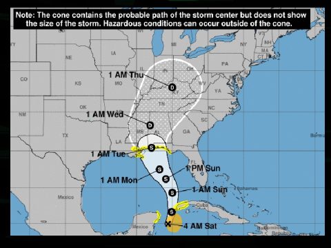
U.S. forecasters followed suit by issuing a tropical storm watch for parts of the Gulf Coast from the Florida Panhandle southwest of Tallahassee to the New Orleans metropolitan area.
At 11 p.m. ET, the National Hurricane Center in Miami said Alberto was centered about 110 miles southeast of Cozumel, Mexico. Its top sustained winds were 40 mph. A gradual strengthening was expected through the weekend as it moves north.
The U.S. is expected to start feeling Alberto’s effects Saturday. The hurricane center said up to 12 inches of rain was possible across the Florida Keys and southern and southwestern Florida. Residents in the storm’s expected path were advised to monitor the storm’s progress. “Flooding potential will increase across this region early next week as Alberto is forecast to slow down after it moves inland,” the hurricane center said.
The National Weather Service said a flash flood watch would be in effect from Saturday evening through Tuesday evening for southeastern Mississippi, southwestern Alabama and the western Florida Panhandle. A storm surge watch was also issued for parts of Florida, Alabama, Mississippi and Louisiana.
A subtropical storm has a less defined and cooler center than a tropical storm, and its strongest winds are found farther from its center. Subtropical storms can develop into tropical storms, which in turn can strengthen into hurricanes. Alberto comes ahead of schedule: the six-month hurricane season doesn’t begin until June 1.
Parts of Florida, Georgia, Alabama, Mississippi and Louisiana have already seen heavy rain this week, and further deluges could leave those areas vulnerable to flash flooding and river flooding. Some beachfront and riverfront communities are already handing out sandbags.
The downpours could dampen Memorial Day, the unofficial start of the summer tourist season along Gulf beaches. Along with heavy rains and high winds come rough seas and a threat of rip currents from Florida to Louisiana that can sweep swimmers out to sea.
In Tallahassee, the city and Leon County are set to open several sandbag locations to the public on Friday in preparation for the possibility of heavy rainfall over the weekend.
As of now, the storm is expected to make landfall and push northward into Tennessee and Kentucky starting Wednesday as a tropical depression.


