
SUN-FILLED WEEKEND, SHOWERS NEXT WEEK
Warm sunshine holds through Sunday before rain chances increase Monday and Tuesday.
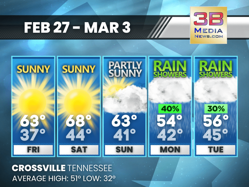
Friday: Sunny, with a high near 63. Calm wind.
Friday Night: Patchy fog after 4am. Otherwise, mostly clear, with a low around 37. Calm wind.
Saturday: Patchy fog before 7am. Otherwise, sunny, with a high near 68. Calm wind becoming west southwest around 5 mph.
Saturday Night: Mostly clear, with a low around 44. Calm wind becoming west around 5 mph.
Sunday: Partly sunny, with a high near 63. West wind around 5 mph becoming north northeast in the afternoon.
Sunday Night: A 30 percent chance of showers after midnight. Cloudy, with a low around 41. East northeast wind around 5 mph.
Monday: A 40 percent chance of showers. Cloudy, with a high near 54. Southeast wind 5 to 10 mph, with gusts as high as 20 mph.
Monday Night: Mostly cloudy, with a low around 42.
Tuesday: A 30 percent chance of showers. Mostly cloudy, with a high near 56.
Tuesday Night: A 30 percent chance of showers. Mostly cloudy, with a low around 45.
Almanac for Crossville, Tennessee for February 27
- Normal High Temperature: 51
- Normal Low Temperature: 32
- Record High Temperature: 71 in 1981
- Record Low Temperature: 5 in 1963
- Record Rainfall: 1.88 in 1962
- Record Snowfall: 4.6 in 1989
- Sunrise: 6:13 AM CST
- Sunset: 5:34 PM CST
- Next Full Moon: Tuesday, March 3, 2026 at 5:38 AM CST (known as the Worm Moon; (Blood Moon) coincides with the occurrence of a total lunar eclipse)
- Daylight Saving Time Begins: Sunday, March 8, 2026 at 2:00 AM EDT
- Spring Equinox: Friday, March 20, 2026 at 9:46 AM CST
Weather information is provided by the National Weather Service in Nashville and Morristown. You can hear the latest forecast on 105.7 The Hog, 94.1 The Vibe (1410 AM), Spirit 101.9, 98.9 The Wolf, and 93.3 The Ranch (580 AM). Stay connected with Weather Reporter Johnny Caudle on social media by following him on Facebook, X, Instagram, Bluesky, and YouTube. You can also click here to send him an email.