
THURSDAY’S 5 DAY FORECAST
The Storm Prediction Center has the Cumberland Plateau in a Slight Risk (threat level 2 of 5, 15-29% chance) for severe weather on Friday. There is a Marginal Risk (threat level 1 of 5, 5-14% chance) across the Tennessee Valley. A Wind Advisory may also be needed for Friday evening according to the National Weather Service.
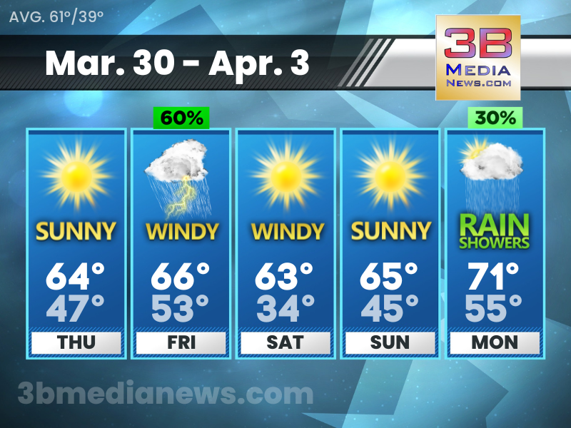
Thursday: Sunny, with a high near 64. Calm wind becoming south southeast around 5 mph in the morning.
Thursday Night: Partly cloudy, with a low around 47. South wind 5 to 10 mph, with gusts as high as 25 mph.
Friday: Showers likely, with thunderstorms also possible after 4pm. Cloudy, with a high near 66. South wind 10 to 20 mph, with gusts as high as 30 mph. Chance of precipitation is 60%.
Friday Night: Showers and possibly a thunderstorm. Low around 53. Windy, with a south wind 15 to 25 mph becoming west southwest after midnight. Winds could gust as high as 35 mph. Chance of precipitation is 100%.
Saturday: Sunny, with a high near 63. Windy, with a west wind 20 to 25 mph, with gusts as high as 35 mph.
Saturday Night: Mostly clear, with a low around 34. West northwest wind 5 to 15 mph, with gusts as high as 20 mph.
Sunday: Sunny, with a high near 65. North northeast wind around 5 mph becoming south southwest in the afternoon.
Sunday Night: Mostly clear, with a low around 45.
Monday: A 30 percent chance of showers. Mostly sunny, with a high near 71.
Monday Night: A 30 percent chance of showers and thunderstorms. Partly cloudy, with a low around 55.
Source – National Weather Service – Nashville
Connect with Weathercaster Johnny Caudle on social media. Follow him on Facebook, Twitter, and Instagram. Send email to [email protected].