
Thursday’s 5 Day Forecast
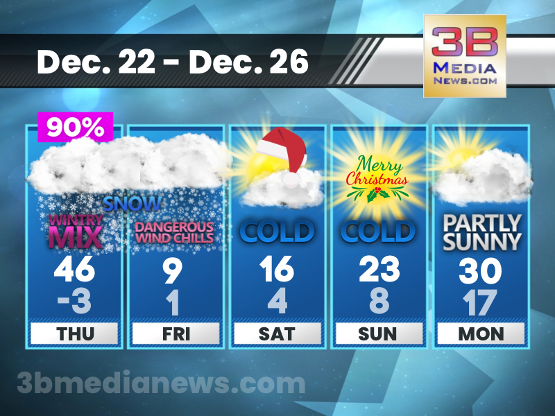
A Wind Chill Warning and a Winter Weather Advisory are in effect. This will be the coldest Christmas since 2020. It was 19 degrees back then, and we’re expecting 23 degrees this Sunday.
THURSDAY: Mostly cloudy, with a high near 46. South wind 5 to 10 mph.
THURSDAY NIGHT: Rain and snow before 1am, then a chance of snow between 1am and 3am, then scattered flurries after 3am. Low around -3. Wind chill values as low as -18. Windy, with a south southwest wind 10 to 15 mph becoming west northwest 20 to 25 mph in the evening. Winds could gust as high as 40 mph. Chance of precipitation is 90%. New snow accumulation of less than a half inch possible.
FRIDAY: Scattered flurries before 1pm. Partly sunny and cold, with a high near 9. Wind chill values as low as -22. West wind 15 to 20 mph, with gusts as high as 30 mph.
FRIDAY NIGHT: Mostly cloudy, with a low around 1. West wind 10 to 15 mph, with gusts as high as 30 mph.
SATURDAY: Mostly sunny, with a high near 16. West wind around 10 mph, with gusts as high as 25 mph.
SATURDAY NIGHT: Partly cloudy, with a low around 4. West northwest wind 5 to 10 mph, with gusts as high as 20 mph.
CHRISTMAS DAY: Mostly sunny, with a high near 23. West northwest wind around 5 mph.
SUNDAY NIGHT: Partly cloudy, with a low around 8. West northwest wind around 5 mph becoming calm.
MONDAY: Partly sunny, with a high near 30.
MONDAY NIGHT: Mostly cloudy, with a low around 17.
Source: National Weather Service – Nashville & Morristown