
WARM, SUNNY DAYS WITH PATCHY FOG AND A FEW WEEKEND STORMS
Morning fog gives way to sunshine through Friday, with a chance of showers and thunderstorms returning Saturday night into Sunday.
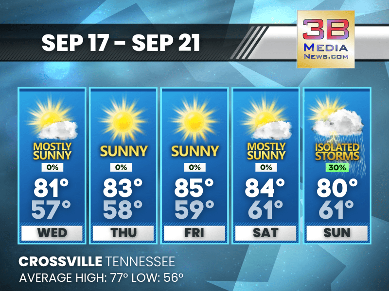
Wednesday: Patchy fog before 9am. Otherwise, mostly sunny, with a high near 81. Calm wind becoming north around 5 mph.
Wednesday Night: Patchy fog between 4am and 5am. Otherwise, mostly clear, with a low around 57. Calm wind.
Thursday: Patchy fog between 7am and 8am. Otherwise, sunny, with a high near 83. Calm wind.
Thursday Night: Mostly clear, with a low around 58. Calm wind.
Friday: Sunny, with a high near 85. Calm wind.
Friday Night: Partly cloudy, with a low around 59. Calm wind.
Saturday: Mostly sunny, with a high near 84. Calm wind becoming south around 5 mph in the afternoon.
Saturday Night: A 20 percent chance of showers and thunderstorms after 1am. Mostly cloudy, with a low around 61.
Sunday: A 30 percent chance of showers and thunderstorms. Mostly sunny, with a high near 80.
Sunday Night: Partly cloudy, with a low around 61.
Almanac for Crossville, Tennessee for September 17, 2025:
- Normal High Temperature: 77
- Normal Low Temperature: 56
- Record High Temperature: 89 in 1991
- Record Low Temperature: 39 in 1961
- Record High Rainfall: 3.50 in 2012
- Sunrise: 6:25 AM CDT
- Sunset: 6:44 PM CDT
- Autumn Equinox: Monday, September 22, 2025 at 1:19 PM CDT
- Next Full Moon: Monday, October 6, 2025 at 10:48 PM CDT (known as the Harvest Moon; this full moon will also be a supermoon)
- Daylight Saving Time Ends: Sunday, November 2, 2025 at 2:00 AM ET
Weather information is provided by the National Weather Service in Nashville and Morristown. You can hear the latest forecast on 105.7 The Hog, 94.1 The Vibe (1410 AM), Spirit 101.9, 98.9 The Wolf, and 93.3 The Ranch (580 AM). Stay connected with Weathercaster Johnny Caudle on social media by following him on Facebook, X, Instagram, Bluesky, and Threads. You can also click here to send him an email.