
WARM SUNSHINE GIVES WAY TO A WET, COOLER WEEKEND
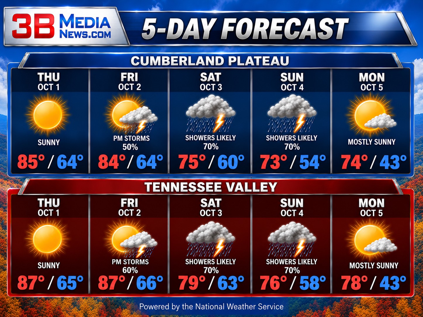
Thursday will be sunny and unusually warm across the Cumberland Plateau and Tennessee Valley. Highs reach the middle 80s on the plateau and upper 80s in the valley, well above the normal high for the beginning of October. Thursday night stays mostly clear to partly cloudy, with lows in the middle 60s.
The weather begins changing Friday as clouds increase and showers develop. The Cumberland Plateau has a 50 percent chance of rain, with thunderstorms possible during the afternoon, while the Tennessee Valley has a 60 percent chance of showers and storms, mainly later in the day. Rain becomes more widespread Friday night and continues through the weekend.
Saturday and Sunday both bring a 70 percent chance of showers on the Cumberland Plateau, with thunderstorms also possible. The Tennessee Valley has similarly wet conditions, including a 70 percent chance Saturday and Sunday. Clouds and rain will knock temperatures down considerably, with weekend highs mainly in the 70s. Conditions improve Monday as the rain moves out and sunshine returns. Monday night turns much cooler, with lows dropping into the lower 40s on the plateau and upper 40s in the valley.
CLIMATE & ALMANAC
Normal High: 73°
Normal Low: 51°
Record High: 91° — 2019
Record Low: 33° — 1974
Record Rainfall: 1.88 inches — 1985
Sunrise: 6:35 AM
Sunset: 6:23 PM
Daylight: 11 hours, 48 minutes
Daylight is decreasing by about 2 minutes, 14 seconds each day.
SKY & SEASONS
Moon: Waning Gibbous, about 74% illuminated
Next Full Moon: Sunday, October 25 at 11:11 PM
Next New Moon: Saturday, October 10 at 10:50 AM
Next Season Change: Winter begins Monday, December 21 at 2:50 PM.
Daylight Saving Time: Ends Sunday, November 1. Clocks fall back one hour at 2:00 AM.
Forecast information provided by the National Weather Service. Climate information is based on National Weather Service and NOAA records. Astronomical information is based on established astronomical calculations.
