
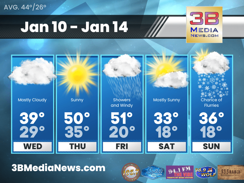
WEDNESDAY’S 5-DAY FORECAST
Winds will decrease across the area this morning and the cloud cover will decrease this afternoon with the return of some sun. Thursday will be the nicest day we have in the forecast with plenty of sunshine and temperatures in the low to mid 50s.
Wednesday: Mostly cloudy, with a high near 39. West wind 10 to 15 mph, with gusts as high as 30 mph.
Wednesday Night: Mostly clear, with a low around 29. South southwest wind 10 to 15 mph, with gusts as high as 20 mph.
Thursday: Sunny, with a high near 50. West southwest wind 5 to 10 mph becoming south southeast in the afternoon. Winds could gust as high as 20 mph.
Thursday Night: A 20 percent chance of showers after midnight. Partly cloudy, with a low around 35. South southeast wind 5 to 15 mph, with gusts as high as 25 mph.
Friday: Showers. High near 51. Windy, with a south southeast wind 20 to 25 mph increasing to 25 to 30 mph in the morning. Winds could gust as high as 50 mph. Chance of precipitation is 100%.
Friday Night: A chance of rain and snow showers before midnight, then a chance of sprinkles and flurries between midnight and 1am, then a chance of flurries after 1am. Mostly cloudy, with a low around 20. Windy, with a west wind 20 to 30 mph, with gusts as high as 45 mph. Chance of precipitation is 40%.
Saturday: Mostly sunny, with a high near 33. West wind 15 to 20 mph, with gusts as high as 30 mph.
Saturday Night: Partly cloudy, with a low around 18. West southwest wind 10 to 15 mph.
Sunday: A chance of flurries after noon. Partly sunny, with a high near 36.
Sunday Night: A 40 percent chance of snow showers. Mostly cloudy, with a low around 18.
Source: National Weather Service Weather Forecast Offices in Nashville and Morristown.
Johnny Caudle has the latest weather forecast every hour on 105.7 The Hog, 94.1 The Vibe, Spirit 101.9, 98.9 The Wolf, and 93.3 The Ranch. Connect with Johnny Caudle on social media. Follow him on Facebook, X, Instagram and Threads. Send email to [email protected].