
WEEKEND STARTS SUNNY, ENDS WITH RAIN CHANCES
Sunny skies and 60s Saturday and Sunday give way to gusty winds, showers, and possible thunderstorms late Sunday before cooler, breezy weather returns for the workweek.
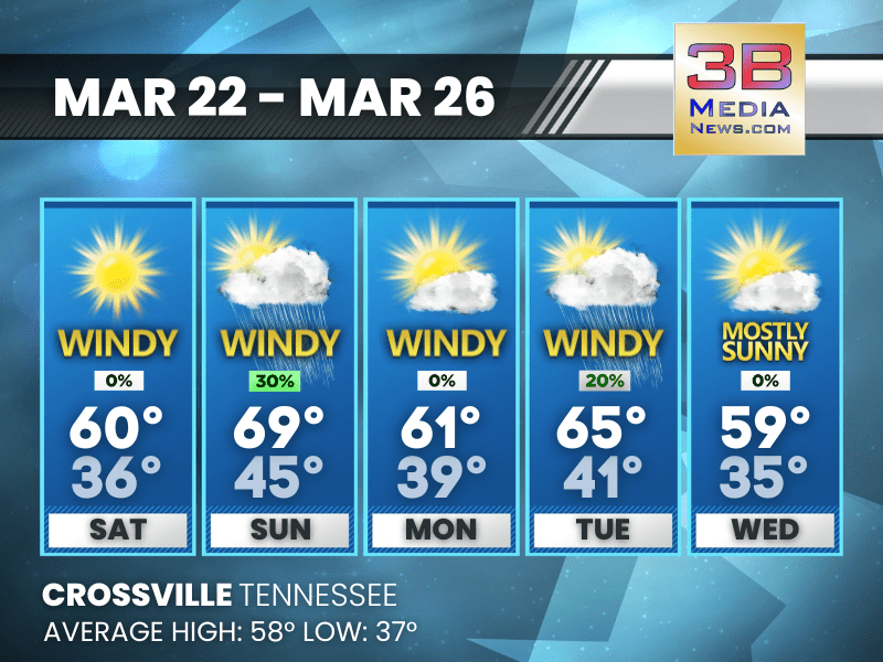
Saturday: Sunny, with a high near 60. West northwest wind around 10 mph, with gusts as high as 25 mph.
Saturday Night: Mostly clear, with a low around 36. West northwest wind around 5 mph becoming calm.
Sunday: A 30 percent chance of showers after 1pm. Mostly sunny, with a high near 69. South wind 5 to 15 mph, with gusts as high as 30 mph.
Sunday Night: Showers and possibly a thunderstorm. Low around 45. South southwest wind around 10 mph becoming west after midnight. Winds could gust as high as 25 mph. Chance of precipitation is 90%.
Monday: Mostly sunny, with a high near 61. West wind 5 to 15 mph, with gusts as high as 25 mph.
Monday Night: Partly cloudy, with a low around 39. West northwest wind around 5 mph becoming calm in the evening.
Tuesday: A 20 percent chance of showers after 1pm. Mostly sunny, with a high near 65. West wind 5 to 10 mph, with gusts as high as 25 mph.
Tuesday Night: Partly cloudy, with a low around 41.
Wednesday: Mostly sunny, with a high near 59.
Wednesday Night: Mostly clear, with a low around 35.
Almanac for Crossville, Tennessee for March 22, 2025:
- Normal High Temperature: 58
- Normal Low Temperature: 37
- Record High Temperature: 78 in 2011
- Record Low Temperature: 12 in 1996
- Sunrise: 6:41 AM CDT
- Sunset: 6:54 PM CDT
- Next Full Moon: Saturday, April 12, 2025 at 7:22 PM CDT (known as the Pink Moon)
- Summer Solstice: Friday, June 20, 2025 at 9:42 PM CDT
Weather information is provided by the National Weather Service in Nashville and Morristown. Hear the latest forecast on 105.7 The Hog, 94.1 The Vibe (1410 AM), Spirit 101.9, 98.9 The Wolf, and 93.3 The Ranch (580 AM). Get connected with Weathercaster Johnny Caudle on social media. Follow him on Facebook, X, Instagram, Bluesky, and Threads. Click here to send him an email.