
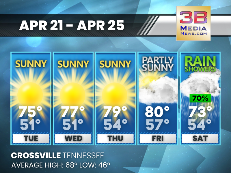
WARM, DRY STRETCH BEFORE WEEKEND SHOWERS
Sunshine dominates through Friday with a steady warm-up, then rain chances increase Saturday. Tuesday: Sunny, with a high near 75. Calm wind becoming west southwest around
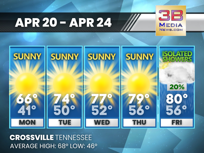
SUNSHINE DOMINATES BEFORE A FEW SHOWERS RETURN
A steady warm-up through the week leads to near 80 by Friday, with only a slight chance of isolated showers late. Monday: Sunny, with a high
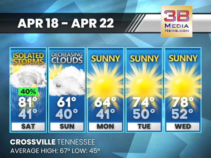
WEEKEND SHOWERS, MIDWEEK SUNSHINE
A few storms and a cooldown early give way to a steady stretch of sunny, warmer days. Saturday: A 40 percent chance of showers and thunderstorms,
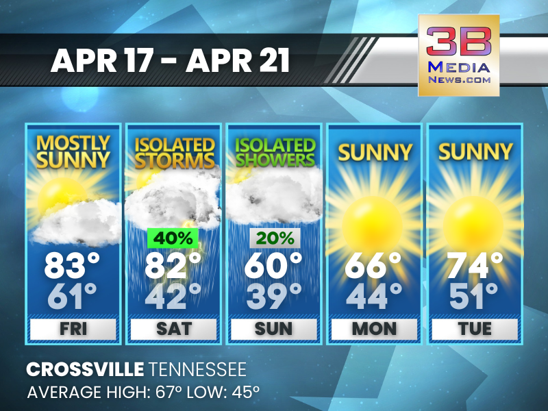
WARM START GIVES WAY TO WEEKEND SHOWERS BEFORE SUNNY REBOUND
Temperatures trend cooler through the weekend with scattered rain chances, followed by a dry and milder start to the new week. Friday: Mostly sunny, with a
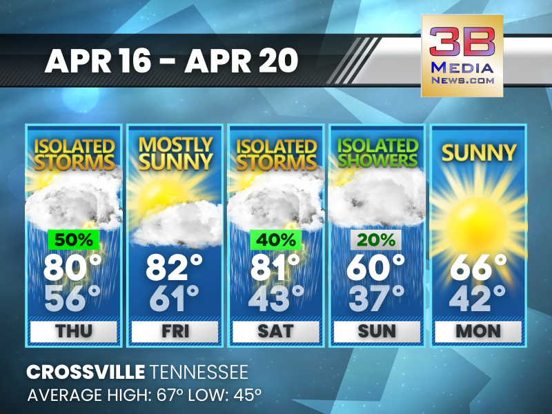
WARM, UNSETTLED WEATHER GIVES WAY TO COOLER SUNSHINE
A mix of isolated storms and sunshine continues before a noticeable cool-down arrives with clearer skies. Thursday: A 50 percent chance of showers and thunderstorms, mainly
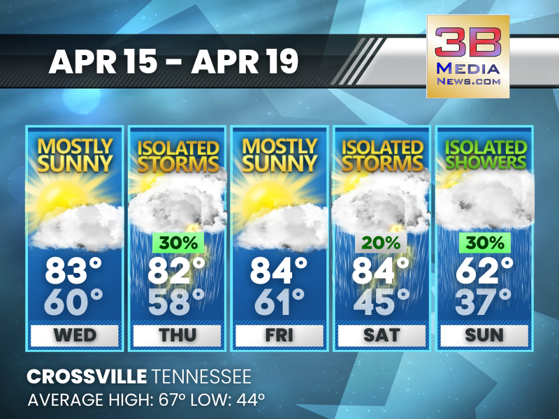
WARM MIDWEEK, STORMS RETURN BEFORE A COOL DOWN
Sunshine dominates early, followed by scattered storms and a noticeable drop in temperatures by the weekend. Wednesday: Mostly sunny, with a high near 83. South southwest
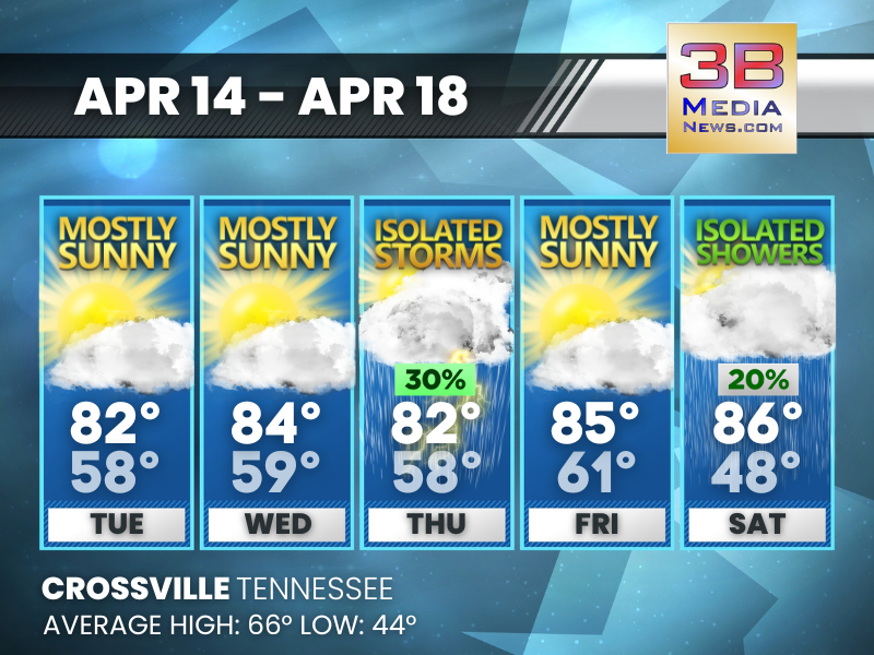
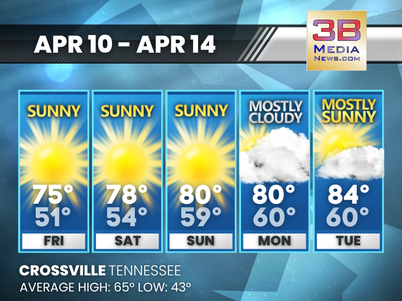
WARM, MOSTLY SUNNY STRETCH WITH A MIDWEEK STORM CHANCE
Temperatures climb well above average with mostly sunny skies dominating, briefly interrupted by a chance of storms late week. Tuesday: Mostly sunny, with a high near
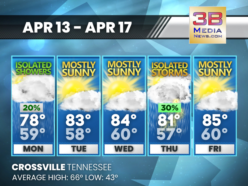
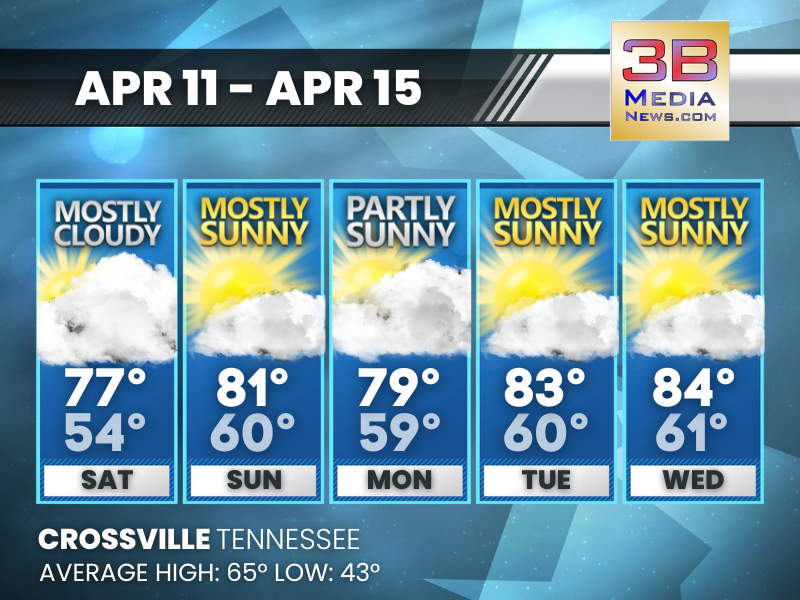
WARM, MOSTLY SUNNY WEEK WITH SPOTTY RAIN CHANCES
A mild stretch brings sunshine most days, with brief chances for isolated showers early and a few storms late in the week. Monday: A slight chance
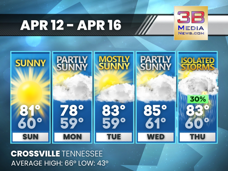
WARM, MOSTLY SUNNY STRETCH WITH LATE-WEEK STORM CHANCE
A mild, pleasant pattern dominates through midweek before a slight uptick in storm chances toward Thursday. Sunday: Sunny, with a high near 81. Light south wind
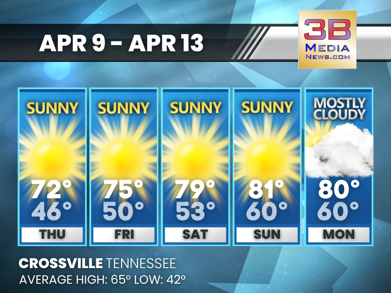
WARMER DAYS TAKE HOLD WITH PLENTY OF SUNSHINE
Temperatures climb well above average with mostly sunny skies dominating the stretch and only brief cloud cover interruptions. Saturday: A 10 percent chance of showers after
SUNSHINE DOMINATES WITH A WARMING TREND AHEAD
A stretch of sunny days gives way to increasing clouds as temperatures climb into the mid-80s. Friday: Sunny, with a high near 75. South wind around
WARMING TREND BUILDS THROUGH THE WEEKEND
A steady stretch of sunshine drives temperatures well above average before clouds return early next week. Thursday: Sunny, with a high near 72. South wind around