
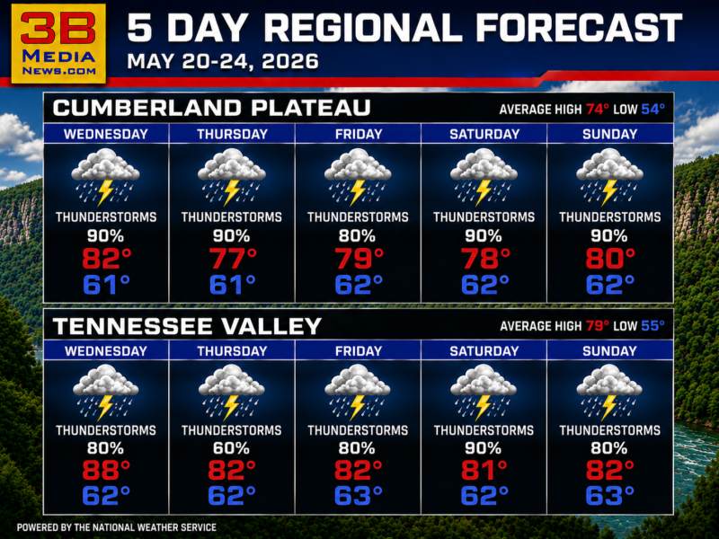
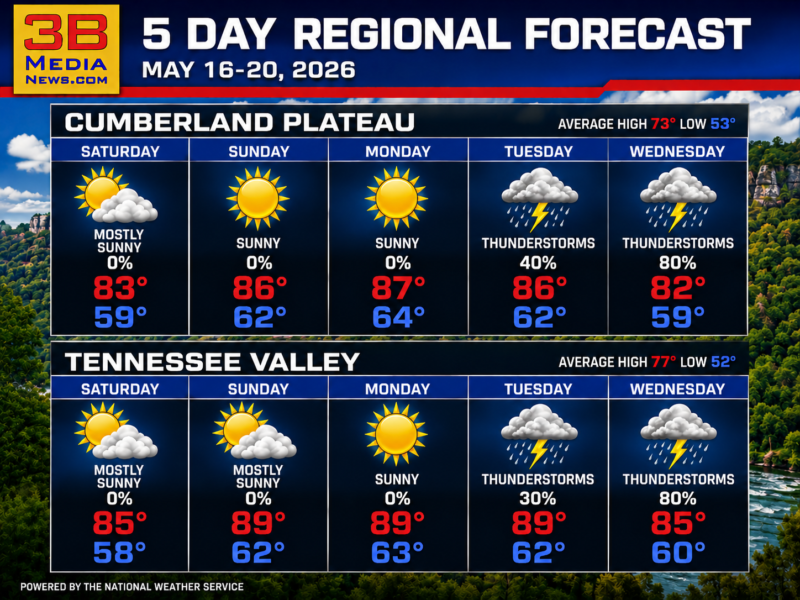
WIDESPREAD THUNDERSTORMS EXPECTED THIS WEEK
Regional Forecast — Cumberland Plateau & Tennessee Valley The Cumberland Plateau and Tennessee Valley will see frequent thunderstorms with high rain chances through Sunday. Wednesday:
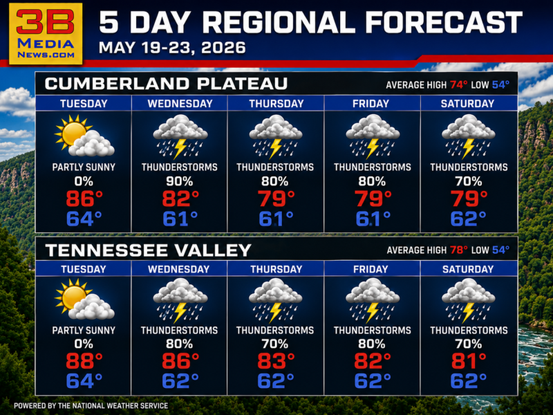
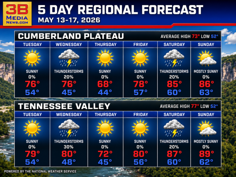
STORMY PATTERN TAKES OVER MIDWEEK
Regional Forecast — Cumberland Plateau & Tennessee Valley After a warm and partly sunny Tuesday, repeated rounds of thunderstorms are expected through the end of
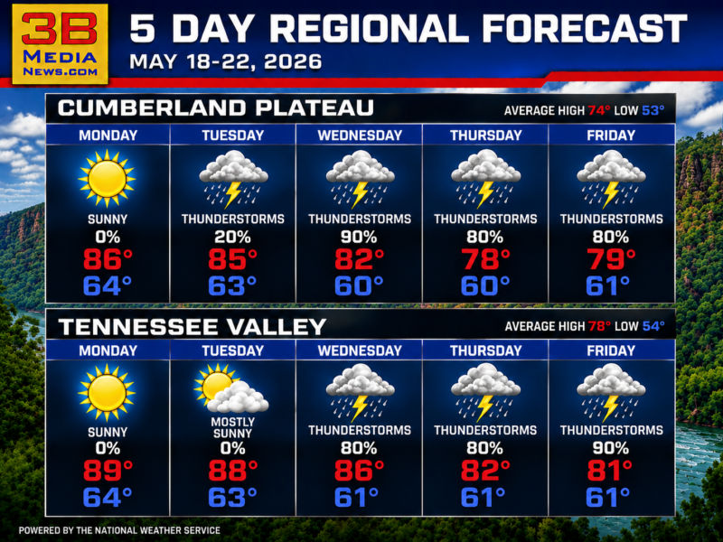
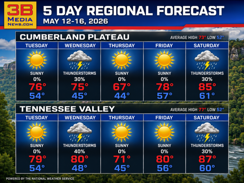
HEAT AND STORMS DOMINATE THE WEEK
Regional Forecast — Cumberland Plateau & Tennessee Valley The week starts hot and sunny before thunderstorms become widespread midweek. Monday: Sunny. Cumberland Plateau high near
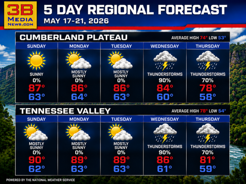
SUNNY SKIES TURN STORMY MIDWEEK
Regional Forecast — Cumberland Plateau & Tennessee Valley Expect mostly sunny conditions early in the week with thunderstorms developing midweek. Sunday: Sunny. Cumberland Plateau high
HEAT PEAKS BEFORE STORMS ARRIVE
Cumberland Plateau & Tennessee Valley Forecast Temperatures climb into the upper 80s early in the week before thunderstorms move in midweek. Saturday: Mostly sunny. Cumberland
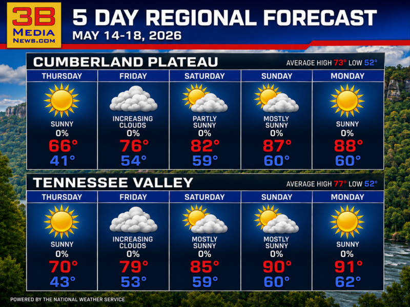
WARMING TREND TAKES HOLD ACROSS THE REGION
Cumberland Plateau & Tennessee Valley Forecast Sunshine and steadily climbing temperatures will push the region into summerlike warmth by early next week. Thursday: Sunny. Highs
WARMER WEATHER BUILDS ACROSS EAST TENNESSEE
Cumberland Plateau & Tennessee Valley Forecast Sunshine dominates much of the forecast with only isolated thunderstorm chances during the middle and latter part of the
WARM SUNSHINE DOMINATES WITH MIDWEEK STORM CHANCES
Cumberland Plateau & Tennessee Valley Forecast Warm afternoons and mostly sunny skies will be interrupted by scattered thunderstorms during the middle of the week. Today:
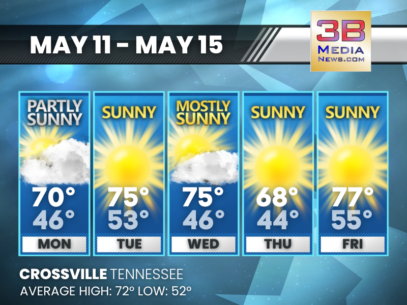
SUNNY SKIES AND MILD TEMPERATURES THROUGH THE WEEK
Expect mostly clear conditions with highs in the mid-70s and lows in the 40s and 50s. Today: A 20 percent chance of showers before 10am. Partly
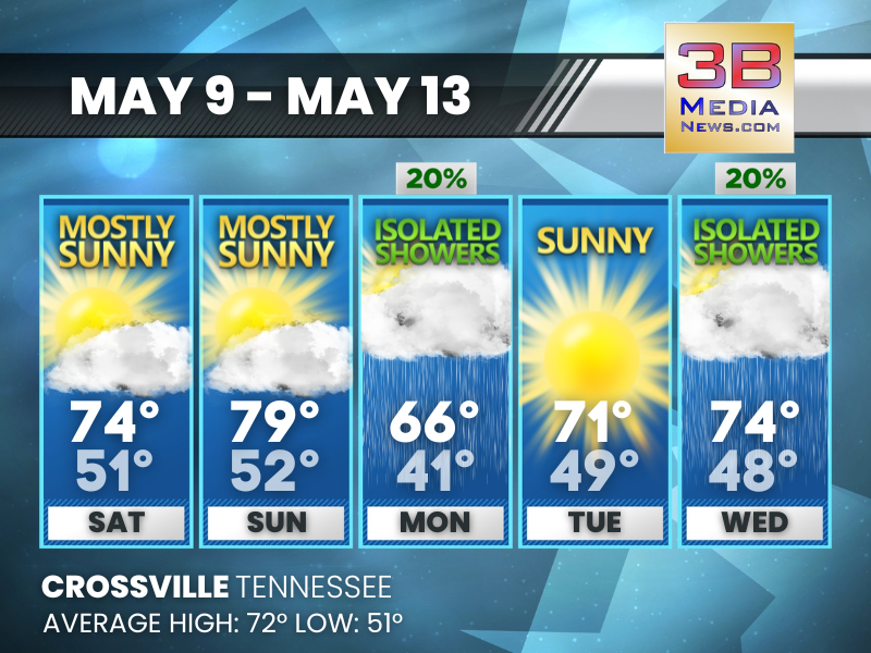
WEEKEND SUN RETURNS WITH COOLER START TO THE WEEK
Expect mostly sunny conditions over the weekend, with isolated showers early next week and comfortable temperatures midweek. Saturday: Mostly sunny, with a high near 74. West
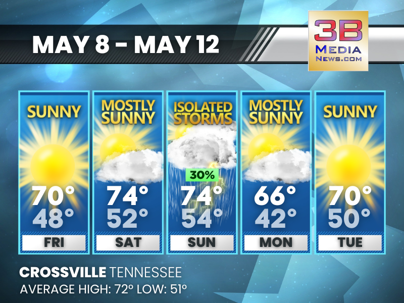
WARM DAYS WITH A BRIEF STORM INTERRUPTION
Sunshine dominates most of the period, with a small storm chance mixed in before cooler air briefly settles in. Friday: Patchy frost before 7am. Otherwise, sunny,
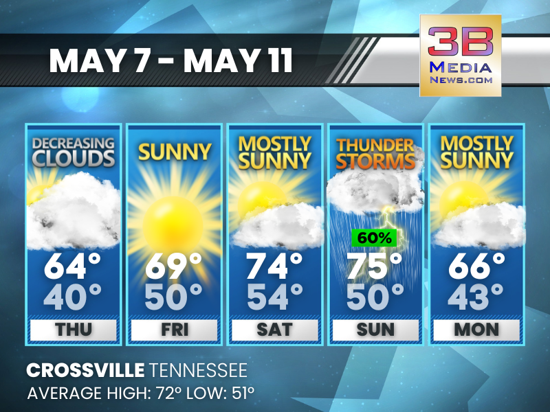
COOL SNAP, SUNSHINE, THEN STORMS
Temperatures recover through the weekend before thunderstorms return and cooler air settles back in. Thursday: Mostly cloudy, then gradually becoming sunny, with a high near 64.