
STORMY STRETCH AHEAD WITH ROUNDS OF RAIN THROUGH MIDWEEK
Multiple rounds of rain and thunderstorms are expected from the weekend into midweek, with mild temperatures continuing throughout the period.
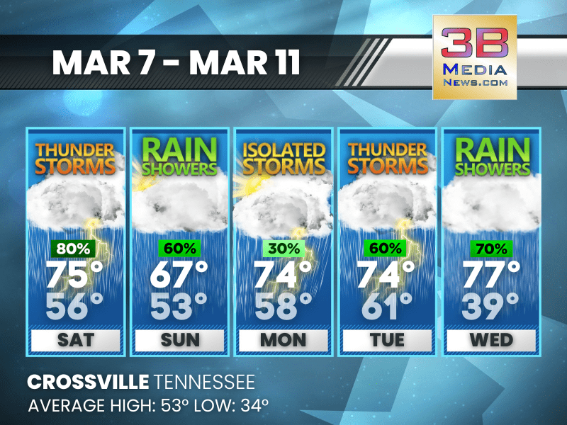
Today: Showers and thunderstorms likely, then showers and possibly a thunderstorm after 3pm. High near 75. South wind 10 to 15 mph, with gusts as high as 25 mph. Chance of precipitation is 80%. New rainfall amounts between a quarter and half of an inch possible.
Tonight: Showers and possibly a thunderstorm before midnight, then showers likely. Low around 56. West southwest wind around 5 mph. Chance of precipitation is 80%. New precipitation amounts between a tenth and quarter of an inch, except higher amounts possible in thunderstorms.
Sunday: Showers likely, mainly before 4pm. Cloudy, then gradually becoming mostly sunny, with a high near 67. West northwest wind around 5 mph. Chance of precipitation is 60%. New precipitation amounts of less than a tenth of an inch possible.
Sunday Night: Partly cloudy, with a low around 53. Calm wind.
Monday: A 30 percent chance of showers and thunderstorms after noon. Mostly sunny, with a high near 74. Calm wind becoming southwest around 5 mph in the morning.
Monday Night: A chance of showers and thunderstorms, then showers likely and possibly a thunderstorm after midnight. Mostly cloudy, with a low around 58. South southwest wind around 5 mph. Chance of precipitation is 70%.
Tuesday: Showers likely, with thunderstorms also possible after noon. Mostly cloudy, with a high near 74. South southwest wind 5 to 10 mph. Chance of precipitation is 60%.
Tuesday Night: A 20 percent chance of showers. Mostly cloudy, with a low around 61. South wind 5 to 10 mph, with gusts as high as 25 mph.
Wednesday: Showers likely, mainly after noon. Mostly cloudy, with a high near 77. South southwest wind 10 to 15 mph, with gusts as high as 30 mph. Chance of precipitation is 70%.
Wednesday Night: Showers, mainly before midnight. Low around 39. Chance of precipitation is 80%.
Almanac for Crossville, Tennessee for March 7
- Normal High Temperature: 53
- Normal Low Temperature: 34
- Record High Temperature: 77 in 2000
- Record Low Temperature: 15 in 1960
- Record Rainfall: 1.38 in 1961
- Record Snowfall: 1.5 in 1982
- Sunrise: 6:02 AM CST
- Sunset: 5:41 PM CST
- Daylight Saving Time Begins: Sunday, March 8, 2026 at 2:00 AM EDT
- Spring Equinox: Friday, March 20, 2026 at 9:46 AM CST
- Next Full Moon: Wednesday, April 1, 2026 at 9:12 PM CST (known as the Pink Moon)
Weather information is provided by the National Weather Service in Nashville and Morristown. You can hear the latest forecast on 105.7 The Hog, 94.1 The Vibe (1410 AM), Spirit 101.9, 98.9 The Wolf, and 93.3 The Ranch (580 AM). Stay connected with Weather Reporter Johnny Caudle on social media by following him on Facebook, X, Instagram, Bluesky, and YouTube. You can also click here to send him an email.