
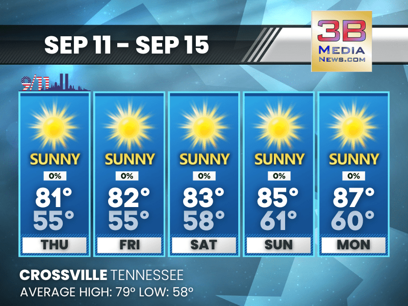
SUNSHINE AND MILD TEMPERATURES CONTINUE THROUGH MONDAY
A stretch of sunny days and clear nights will keep highs in the low to mid-80s and lows in the mid to upper 50s, with calm winds and just a touch of patchy fog late Thursday night. Thursday: Sunny, ...
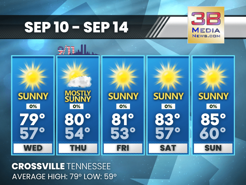
SUNNY SKIES AND MILD TEMPS THROUGH THE WEEKEND
Patchy morning fog will give way to plenty of sunshine and comfortable highs in the upper 70s to mid 80s, with clear and cool nights. Wednesday: Patchy fog before 7am. Otherwise, sunny, with a high ...

SUNNY DAYS AHEAD WITH WARMER TEMPS BUILDING THROUGH THE WEEK
Sunshine dominates the forecast, with highs climbing from the upper 70s Tuesday to the low 80s by Friday and Saturday under calm winds. Tuesday: Sunny, with a high near 77. Calm wind. Tuesday Ni ...
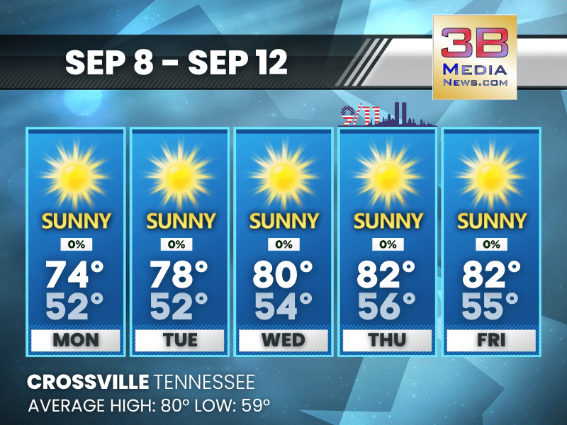
SUNNY SKIES AND WARMING TEMPERATURES ALL WEEK
Expect a stretch of sunny days with highs climbing from the mid-70s Monday to the low 80s by Thursday and Friday. Monday: Sunny, with a high near 74. Northeast wind around 5 mph. Monday Night: M ...

SUNNY DAYS AHEAD WITH COOL NIGHTS THROUGH MIDWEEK
Expect bright skies and comfortable temperatures from Sunday through Thursday, with highs in the 70s to low 80s and mostly clear nights in the 40s and 50s. Sunday: Patchy fog before 9am. Otherwise, ...

SHOWERS AND STORMS EARLY SATURDAY, SUNNY DAYS RETURN SUNDAY
Rain and thunderstorms taper off Saturday with cooler air arriving, followed by a stretch of clear, sunny weather into midweek. Saturday: Showers and thunderstorms likely, mainly before 1pm. Mostly ...

SUNNY FRIDAY BEFORE STORMS ROLL IN OVER THE WEEKEND
Friday brings sunshine and highs in the mid-80s before showers and thunderstorms move in late Friday night through Saturday. Friday: Mostly sunny, with a high near 85. Southwest wind 5 to 10 mph. ...

SHOWERS AND STORMS THURSDAY, SUNNY FRIDAY, COOLER WEEKEND AHEAD
Storms are likely Thursday with a high near 77 before skies clear for a warmer, sunny Friday; more showers return Saturday before cooler, mostly sunny weather arrives Sunday. Thursday: A chance of ...
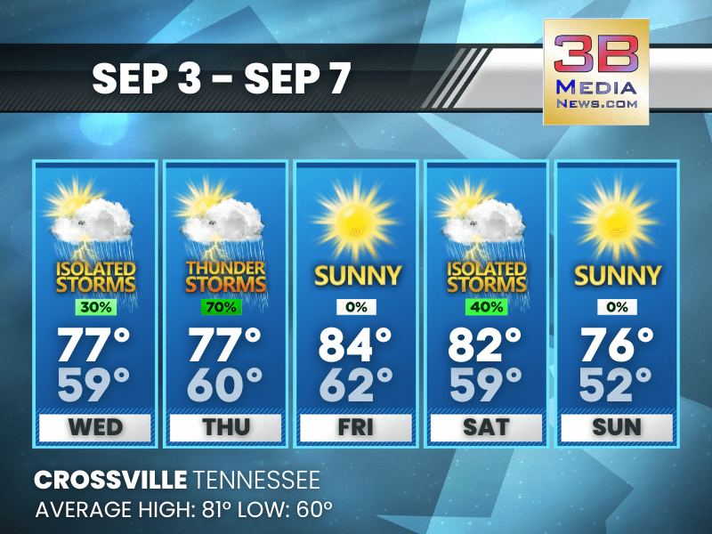
MIDWEEK STORMS, SUN BREAKS, AND A CHANCE AGAIN BY SATURDAY
After scattered storms Wednesday and Thursday, conditions improve Friday before more showers return Saturday. Wednesday: A 30 percent chance of showers and thunderstorms, mainly before 1pm. Mostly ...
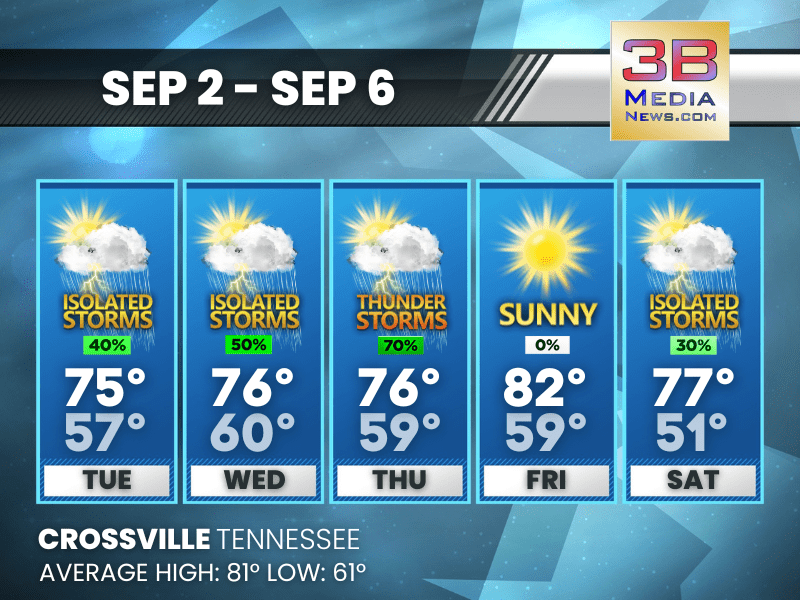
SHOWERS AND THUNDERSTORMS RETURN MIDWEEK WITH UNSETTLED WEATHER
Scattered storms are possible Tuesday and Wednesday, with a wetter Thursday before sunshine returns Friday. Tuesday: A chance of showers, with thunderstorms also possible after 10am. Partly sunny, ...

LABOR DAY STARTS DRY BUT MIDWEEK BRINGS MORE RAIN CHANCES
Labor Day will be mostly sunny with only a few afternoon showers, but increasing rain and storm chances return Tuesday through Thursday before sunshine returns Friday. Labor Day: A 30 percent chanc ...

UNSETTLED LABOR DAY WEEK AHEAD WITH SHOWERS AND STORMS LIKELY
After a pleasant Sunday, rain chances increase Labor Day and continue through midweek with scattered showers and thunderstorms. Sunday: Partly sunny, with a high near 80. Calm wind. Sunday Night ...
