
SEVERE THUNDERSTORM WARNING FOR FENTRESS, PICKETT
BULLETIN - IMMEDIATE BROADCAST REQUESTED Severe Thunderstorm Warning National Weather Service Nashville TN 6:03 AM CDT Thu Apr 3 2025 The National Weather Service in Nashville has issued a Sever ...
HEAVY RAIN, FLOODING, AND SEVERE WEATHER EXPECTED THROUGH WEEKEND
The National Weather Service in Nashville is warning residents of Middle Tennessee to prepare for multiple rounds of heavy rain and severe weather through the weekend, with the greatest impacts expect ...

TORNADO WATCH EXTENDED FOR PICKETT, FENTRESS
Tornado Watch 104, previously in effect until 6 AM CDT early this morning, is now in effect until 8 AM CDT this morning for the following areas: In Tennessee, this watch includes 25 counties in Middl ...
SEVERE THUNDERSTORM WARNING FOR NORTHWESTERN PICKETT COUNTY
BULLETIN - IMMEDIATE BROADCAST REQUESTED Severe Thunderstorm Warning National Weather Service Nashville TN 5:14 AM CDT Thu Apr 3 2025 The National Weather Service in Nashville has issued a Sever ...
FLASH FLOOD WARNING FOR NORTHWESTERN PICKETT COUNTY
BULLETIN - EAS ACTIVATION REQUESTED Flash Flood Warning National Weather Service Nashville TN 4:47 AM CDT Thu Apr 3 2025 The National Weather Service in Nashville has issued a Flash Flood Warnin ...
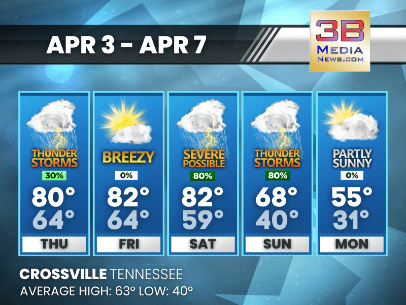
STORMS LOOM THIS WEEKEND AFTER WARM, BREEZY STRETCH
Spotty Thursday storms give way to sunny skies Friday and Saturday—but a late Saturday night system could bring severe weather and heavy rain, followed by a sharp Sunday cooldown. Thursday: A 30 pe ...

TORNADO WATCH IN EFFECT FOR PICKETT AND FENTRESS COUNTIES
A Tornado Watch is in effect until 6:00 AM CDT Thursday, April 3, 2025, for Pickett County, TN and Fentress County, TN. Threat Information: Tornadoes: A few tornadoes likely Hail: Sca ...

SEVERE STORMS AND FLOODING THREATEN MIDDLE TENNESSEE
The National Weather Service is warning of a multi-day severe weather and flooding threat across Middle Tennessee through the weekend. Beginning late Wednesday, multiple rounds of showers and thunders ...

STORM THREAT BUILDS: SEVERE THUNDERSTORMS POSSIBLE THROUGH SATURDAY NIGHT
A multi-day storm setup could bring gusty winds, lightning, and heavy rain—especially late Saturday. Stay weather-aware through the weekend. Wednesday: Mostly cloudy, with a high near 76. South win ...

WIND ADVISORY ISSUED FOR MIDDLE AND EAST TENNESSEE
The National Weather Service has issued Wind Advisories for portions of Middle and East Tennessee beginning early Wednesday. In Middle Tennessee, including Cumberland, Fentress, and Pickett counties, ...

FLOOD WATCH ISSUED FOR MIDDLE TENNESSEE
The National Weather Service in Nashville has issued a Flood Watch for portions of Middle Tennessee, including Pickett County, beginning Wednesday evening and continuing through Sunday morning. Forec ...

SEVERE STORM THREAT FOR CROSSVILLE WEDNESDAY INTO THURSDAY
The National Weather Service in Nashville and the Storm Prediction Center are highlighting a risk for severe thunderstorms in the Crossville area beginning Wednesday evening and continuing into Thursd ...