
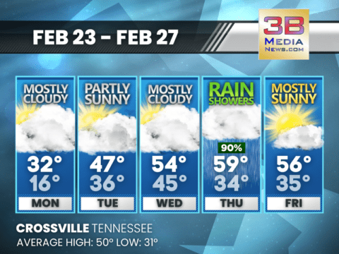
COLD START, MIDWEEK WARM-UP, RAIN THURSDAY
After a chilly Monday, temperatures climb into the 50s by midweek before widespread rain arrives Thursday and sunshine returns Friday. Monday: A chance of flurries before

COLD START, MIDWEEK WARMUP, RAIN TO END THE WEEK
Temperatures rebound into the 50s by midweek before rain showers move in late with an 80 percent chance by Thursday. Today: Increasing clouds, with a high
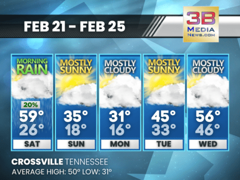
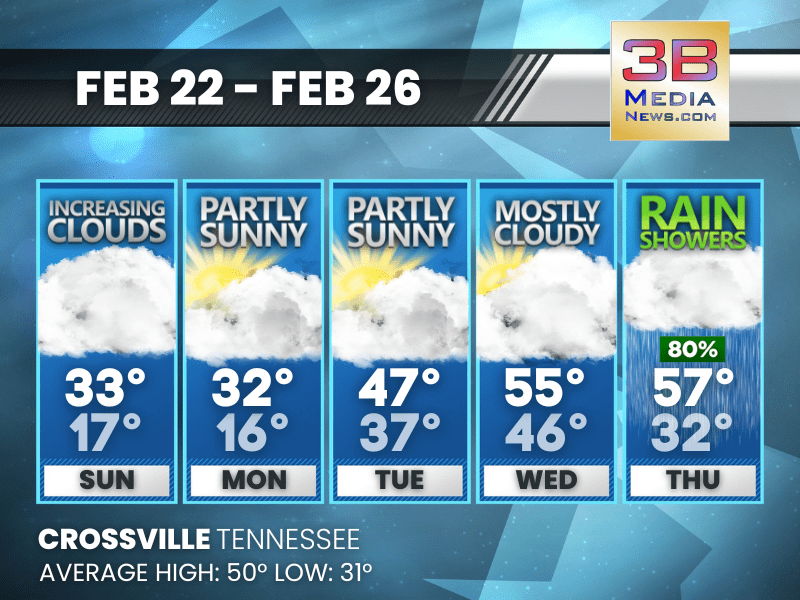
WEEKEND RAIN, EARLY CHILL, MIDWEEK REBOUND
Morning rain Saturday gives way to a sharp cool-down Sunday and Monday before temperatures moderate again by midweek. Saturday: A 20 percent chance of rain before
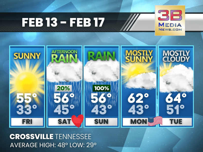
WARM FRIDAY, SHARP WEEKEND COOL-DOWN
Mild air peaks Friday before a sharp drop brings colder, mostly cloudy conditions into early next week, followed by sunshine and a modest rebound Tuesday.
WARM RAIN TO WINTER CHILL IN FIVE DAYS
A mild, rainy Thursday gives way to sunshine, then a sharp cooldown with much colder temperatures by Sunday and Monday. Thursday: A 50 percent chance of
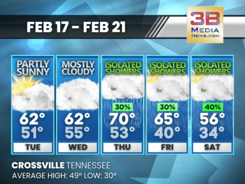
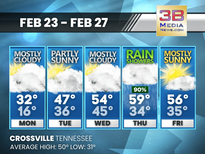
MILD MIDWEEK, SHARPLY COLDER WEEKEND WITH SHOWERS
Isolated showers develop late week before temperatures tumble into the weekend. Wednesday: Cloudy, with a high near 62. Southwest wind 5 to 15 mph, with gusts
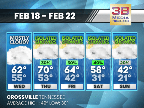
WARM START, SHOWERY FINISH AHEAD
Mild temperatures peak near 70 Thursday before isolated showers and cooler air arrive late week. Tuesday: Partly sunny, with a high near 62. South wind 5
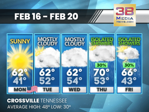
MILD WEEK AHEAD WITH LATE RAIN CHANCES
Temperatures stay well above average through midweek before isolated showers arrive Thursday and Friday. Today: Sunny, with a high near 62. Northeast wind around 5
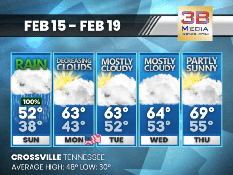
RAINY START, MILDER WEEK AHEAD
Heavy rain kicks off Sunday before a gradual warmup brings milder temperatures and partial sunshine by Thursday. Sunday: Showers, mainly before 2pm. High near 52. Southeast
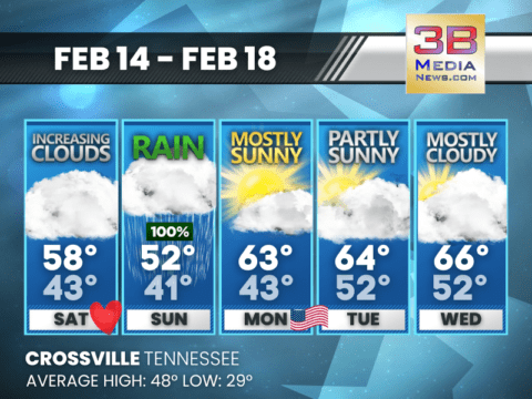
WET SUNDAY, WARMER DAYS AHEAD
Rain moves in Sunday before a steady warming trend brings milder and brighter conditions through midweek. Saturday: Increasing clouds, with a high near 58. Calm wind

T.E.M.A. AND NATIONAL WEATHER SERVICE URGE CITIZENS TO PREPARE FOR SEVERE SPRING WEATHER
As Tennessee approaches the spring severe weather season, the Tennessee Emergency Management Agency (TEMA) is partnering with the National Weather Service (NWS) to raise awareness
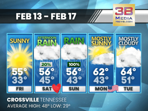
WEEKEND RAIN, WARMER DAYS AHEAD
A mild weekend turns rainy before drier and warmer air returns early next week. Friday: Sunny, with a high near 55. Calm wind becoming east around
COLD START, MIDWEEK WARM-UP, RAIN THURSDAY
After a chilly Monday, temperatures climb into the 50s by midweek before widespread rain arrives Thursday and sunshine returns Friday. Monday: A chance of flurries before 9am. Mostly cloudy, with a ...
COLD START, MIDWEEK WARMUP, RAIN TO END THE WEEK
Temperatures rebound into the 50s by midweek before rain showers move in late with an 80 percent chance by Thursday. Today: Increasing clouds, with a high near 33. Northwest wind 10 to 20 mph, with ...

WEEKEND RAIN, EARLY CHILL, MIDWEEK REBOUND
Morning rain Saturday gives way to a sharp cool-down Sunday and Monday before temperatures moderate again by midweek. Saturday: A 20 percent chance of rain before 8am. Mostly cloudy, with a high ne ...

WARM FRIDAY, SHARP WEEKEND COOL-DOWN
Mild air peaks Friday before a sharp drop brings colder, mostly cloudy conditions into early next week, followed by sunshine and a modest rebound Tuesday. Friday: Partly sunny, then gradually becom ...

WARM RAIN TO WINTER CHILL IN FIVE DAYS
A mild, rainy Thursday gives way to sunshine, then a sharp cooldown with much colder temperatures by Sunday and Monday. Thursday: A 50 percent chance of showers and thunderstorms, mainly before 10a ...
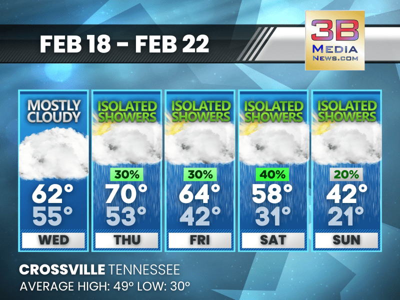
MILD MIDWEEK, SHARPLY COLDER WEEKEND WITH SHOWERS
Isolated showers develop late week before temperatures tumble into the weekend. Wednesday: Cloudy, with a high near 62. Southwest wind 5 to 15 mph, with gusts as high as 25 mph. Wednesday Night: ...
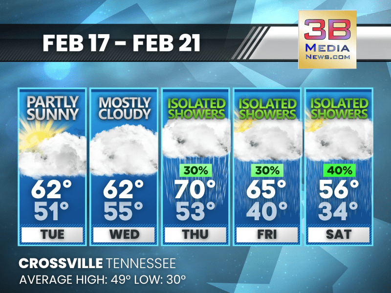
WARM START, SHOWERY FINISH AHEAD
Mild temperatures peak near 70 Thursday before isolated showers and cooler air arrive late week. Tuesday: Partly sunny, with a high near 62. South wind 5 to 10 mph, with gusts as high as 20 mph. ...
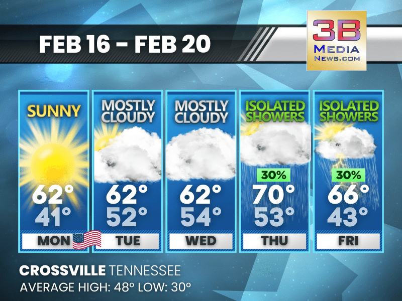
MILD WEEK AHEAD WITH LATE RAIN CHANCES
Temperatures stay well above average through midweek before isolated showers arrive Thursday and Friday. Today: Sunny, with a high near 62. Northeast wind around 5 mph becoming calm in the morning. ...
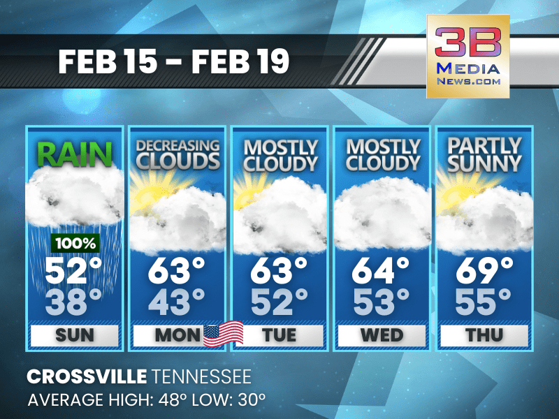
RAINY START, MILDER WEEK AHEAD
Heavy rain kicks off Sunday before a gradual warmup brings milder temperatures and partial sunshine by Thursday. Sunday: Showers, mainly before 2pm. High near 52. Southeast wind 5 to 10 mph becomin ...

WET SUNDAY, WARMER DAYS AHEAD
Rain moves in Sunday before a steady warming trend brings milder and brighter conditions through midweek. Saturday: Increasing clouds, with a high near 58. Calm wind becoming south around 5 mph in ...

T.E.M.A. AND NATIONAL WEATHER SERVICE URGE CITIZENS TO PREPARE FOR SEVERE SPRING WEATHER
As Tennessee approaches the spring severe weather season, the Tennessee Emergency Management Agency (TEMA) is partnering with the National Weather Service (NWS) to raise awareness about the growing ri ...
WEEKEND RAIN, WARMER DAYS AHEAD
A mild weekend turns rainy before drier and warmer air returns early next week. Friday: Sunny, with a high near 55. Calm wind becoming east around 5 mph. Friday Night: Partly cloudy, with a low ...