

WIND, SNOW SHOWERS, THEN A MIDWEEK WARMUP
Gusty conditions give way to snow showers and a sharp chill before temperatures rebound with more sunshine later in the week. Sunday: Mostly cloudy, with a
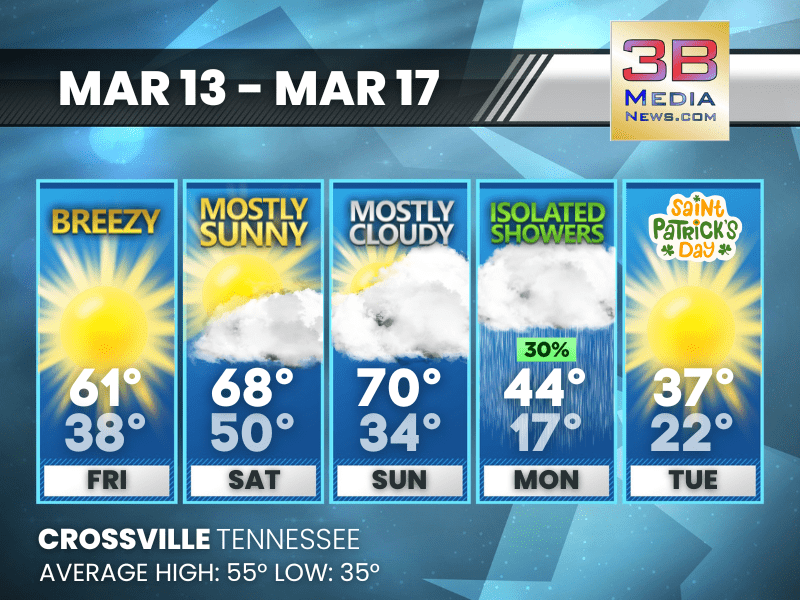
WARM WEEKEND GIVES WAY TO RAIN AND A SHARP EARLY-WEEK CHILL
Mild sunshine and breezy conditions this weekend will be followed by rain Monday and a noticeable drop in temperatures before a gradual midweek recovery. Saturday: Sunny,

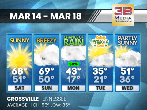
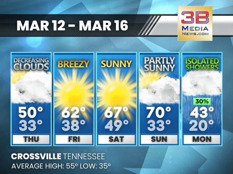
WARM WEEKEND BEFORE A SHARP EARLY-WEEK COOL DOWN
Temperatures climb into the upper 60s and near 70 through the weekend before showers and much colder air arrive early next week. Friday: Sunny, with a
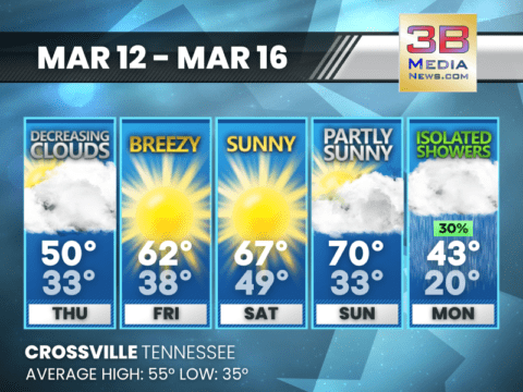
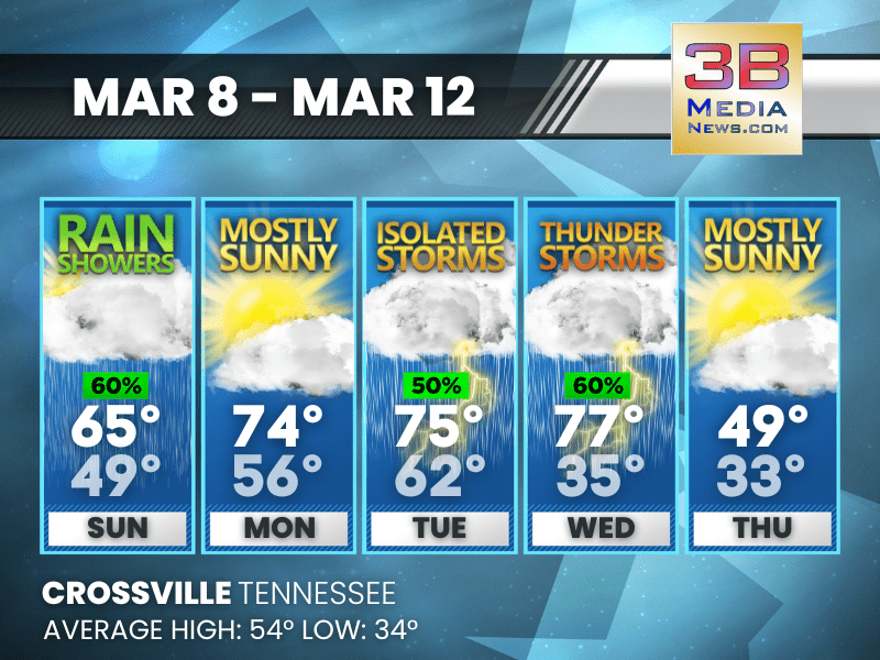
SUNSHINE BUILDS TO 70 BEFORE COOL, SHOWERY TURN
Clouds thin out Thursday, followed by breezy and increasingly warm sunshine through the weekend before a cooler pattern returns with isolated showers Monday. Thursday: Cloudy through

SEVERE THUNDERSTORM WARNING FOR RHEA, MEIGS, BLEDSOE
The National Weather Service in Morristown, Tennessee, has issued a Severe Thunderstorm Warning for Rhea County, north-central Meigs County, and northeastern Bledsoe County in eastern

SEVERE THUNDERSTORM WATCH ISSUED UNTIL 8:00 P.M.
A Severe Thunderstorm Watch is in effect until 8:00 PM CDT this evening for portions of Middle Tennessee, including Cumberland, Pickett, and Fentress counties. The
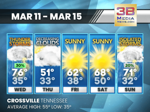
STORMS MIDWEEK, SUNSHINE RETURNS BEFORE A LATE WEEKEND SHOWER CHANCE
Thunderstorms give way to clearing skies and a sunny stretch before a few isolated storms return late in the weekend. Wednesday: A 30 percent chance of
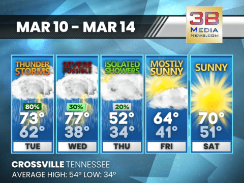
STORMS AND SEVERE THREAT MIDWEEK BEFORE A SUNNY REBOUND
Thunderstorms could turn severe midweek before cooler air moves in, followed by improving skies and sunshine heading into the weekend. Tuesday: Showers and thunderstorms, mainly before
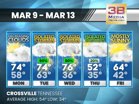
WARM STRETCH FOLLOWED BY MIDWEEK STORMS AND A COOLER TURN
Unseasonably warm temperatures early in the period give way to scattered storms before cooler air arrives late week with improving sunshine. Monday: Partly sunny, then gradually
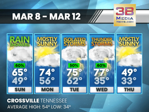
RAIN AND STORMS MIDWEEK BEFORE A SHARP COOL-DOWN
Rain and thunderstorms increase through midweek, followed by a noticeable drop in temperatures by Thursday. Sunday: Showers likely before 4pm, then a slight chance of showers
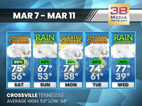
STORMY STRETCH AHEAD WITH ROUNDS OF RAIN THROUGH MIDWEEK
Multiple rounds of rain and thunderstorms are expected from the weekend into midweek, with mild temperatures continuing throughout the period. Today: Showers and thunderstorms likely, then
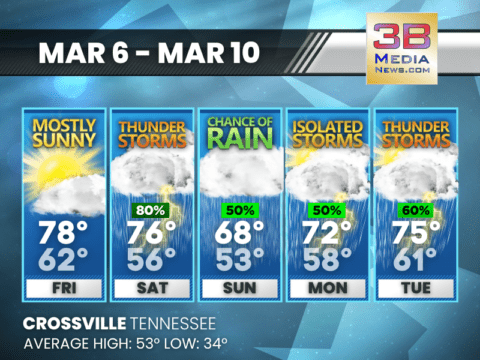
WARM START GIVES WAY TO STORMY STRETCH INTO EARLY WEEK
A warm and mostly sunny Friday is followed by several days of showers and thunderstorms through early next week. Today: Mostly sunny, with a high near
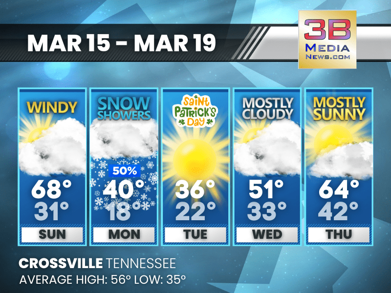
WIND, SNOW SHOWERS, THEN A MIDWEEK WARMUP
Gusty conditions give way to snow showers and a sharp chill before temperatures rebound with more sunshine later in the week. Sunday: Mostly cloudy, with a high near 68. South wind 10 to 20 mph, wi ...

WARM WEEKEND GIVES WAY TO RAIN AND A SHARP EARLY-WEEK CHILL
Mild sunshine and breezy conditions this weekend will be followed by rain Monday and a noticeable drop in temperatures before a gradual midweek recovery. Saturday: Sunny, with a high near 68. Calm ...
WARM WEEKEND BEFORE A SHARP EARLY-WEEK COOL DOWN
Temperatures climb into the upper 60s and near 70 through the weekend before showers and much colder air arrive early next week. Friday: Sunny, with a high near 61. West southwest wind around 15 mp ...
SUNSHINE BUILDS TO 70 BEFORE COOL, SHOWERY TURN
Clouds thin out Thursday, followed by breezy and increasingly warm sunshine through the weekend before a cooler pattern returns with isolated showers Monday. Thursday: Cloudy through mid morning, t ...

SEVERE THUNDERSTORM WARNING FOR RHEA, MEIGS, BLEDSOE
The National Weather Service in Morristown, Tennessee, has issued a Severe Thunderstorm Warning for Rhea County, north-central Meigs County, and northeastern Bledsoe County in eastern Tennessee until ...

SEVERE THUNDERSTORM WATCH ISSUED UNTIL 8:00 P.M.
A Severe Thunderstorm Watch is in effect until 8:00 PM CDT this evening for portions of Middle Tennessee, including Cumberland, Pickett, and Fentress counties. The watch began at 1:20 PM Wednesday, Ma ...

STORMS MIDWEEK, SUNSHINE RETURNS BEFORE A LATE WEEKEND SHOWER CHANCE
Thunderstorms give way to clearing skies and a sunny stretch before a few isolated storms return late in the weekend. Wednesday: A 30 percent chance of showers and thunderstorms, mainly after 5pm. ...

STORMS AND SEVERE THREAT MIDWEEK BEFORE A SUNNY REBOUND
Thunderstorms could turn severe midweek before cooler air moves in, followed by improving skies and sunshine heading into the weekend. Tuesday: Showers and thunderstorms, mainly before noon. High n ...

WARM STRETCH FOLLOWED BY MIDWEEK STORMS AND A COOLER TURN
Unseasonably warm temperatures early in the period give way to scattered storms before cooler air arrives late week with improving sunshine. Monday: Partly sunny, then gradually becoming sunny, wit ...
RAIN AND STORMS MIDWEEK BEFORE A SHARP COOL-DOWN
Rain and thunderstorms increase through midweek, followed by a noticeable drop in temperatures by Thursday. Sunday: Showers likely before 4pm, then a slight chance of showers after 5pm. Cloudy, the ...
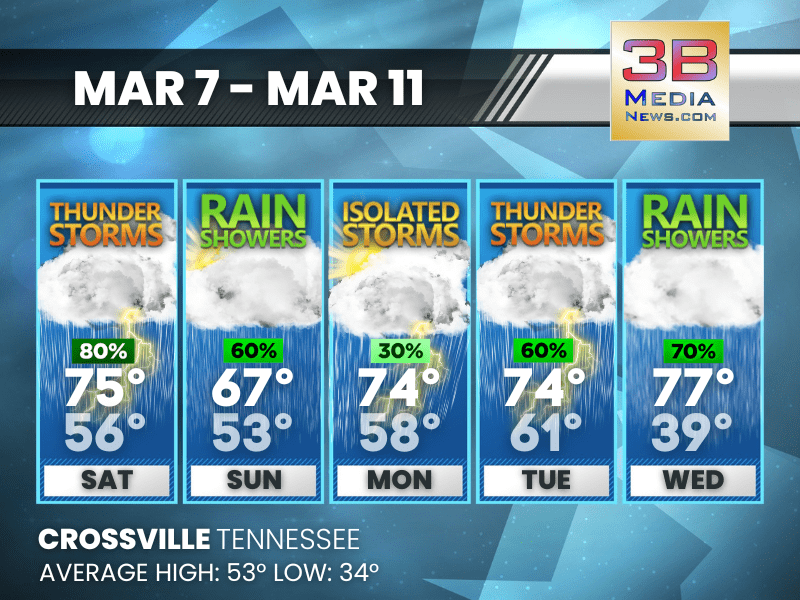
STORMY STRETCH AHEAD WITH ROUNDS OF RAIN THROUGH MIDWEEK
Multiple rounds of rain and thunderstorms are expected from the weekend into midweek, with mild temperatures continuing throughout the period. Today: Showers and thunderstorms likely, then showers ...

WARM START GIVES WAY TO STORMY STRETCH INTO EARLY WEEK
A warm and mostly sunny Friday is followed by several days of showers and thunderstorms through early next week. Today: Mostly sunny, with a high near 78. South wind 5 to 10 mph, with gusts as high ...