
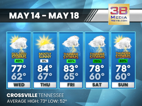
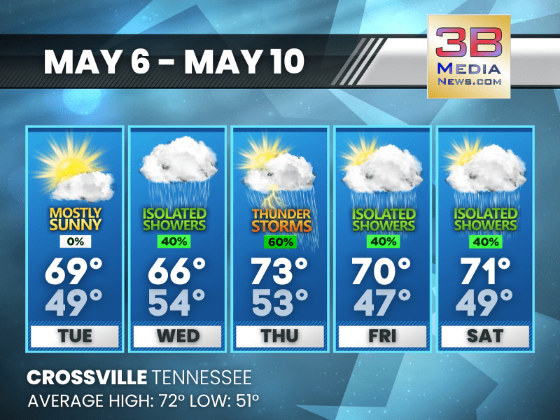
STORM CHANCES BUILD THROUGH WEEKEND
Spotty showers midweek give way to increasing thunderstorm risk Friday through Sunday. Wednesday: A slight chance of showers, then a chance of showers and thunderstorms after

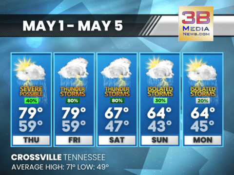
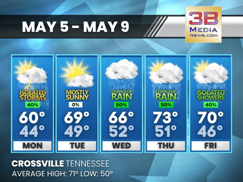
STORMY START, SUMMER FINISH
Unsettled weather through Friday with thunderstorms likely — calmer, warmer pattern takes hold by the weekend. Monday: Showers likely and possibly a thunderstorm before 9am, then

SEVERE THUNDERSTORMS SLAM PARTS OF EAST AND MIDDLE TN THURSDAY AFTERNOON
A series of severe thunderstorms swept across portions of East and Middle Tennessee Thursday afternoon, prompting multiple warnings from the National Weather Service offices in

SEVERE THUNDERSTORM WATCH EXPANDED TO EAST TN
The National Weather Service has issued a Severe Thunderstorm Watch for much of East Tennessee, effective until 11:00 PM EDT Thursday, May 8, 2025. Areas

SEVERE THUNDERSTORM WATCH ISSUED
A Severe Thunderstorm Watch is in effect until 8:00 PM CDT Thursday, May 8, 2025, for much of Middle Tennessee and southern Kentucky, including the

SEVERE STORMS POSSIBLE THURSDAY WITH DAMAGING WINDS AND LARGE HAIL
The National Weather Service is monitoring a developing severe weather threat for Thursday, May 8, across parts of the Tennessee Valley and Southern Appalachians. A

SEVERE STORMS POSSIBLE THURSDAY WITH HAIL AND DAMAGING WINDS
Unsettled weather will continue through Monday, with daily chances for rain and high temperatures ranging from the 60s to low 70s. Thursday: Showers and thunderstorms likely,

SUNSHINE FADES AS SHOWERS RETURN MIDWEEK
Calm, mild start gives way to increasing clouds and rain chances from Wednesday through Saturday. Tuesday: Mostly sunny, with a high near 69. Calm wind becoming

COOL START TO THE WEEK WITH PATCHY FOG AND SCATTERED SHOWERS
Rain chances build midweek, with highs climbing from the 60s into the low 70s by Thursday. Monday: A chance of showers and thunderstorms. Patchy fog before

WET WEEKEND AHEAD WITH THUNDERSTORMS LIKELY
Scattered storms begin today, with widespread rain and possible thunder Saturday; gradual clearing returns by Monday. Today: A 40 percent chance of showers and thunderstorms

THUNDERSTORM WATCH IN EFFECT UNTIL 5
THE NATIONAL WEATHER SERVICE HAS ISSUED SEVERE THUNDERSTORM WATCH 209 IN EFFECT UNTIL 5 PM CDT THIS AFTERNOON FOR THE FOLLOWING AREAS IN TENNESSEE THIS
STORMY STRETCH AHEAD: THUNDERSTORMS LIKELY THROUGH SATURDAY
Rain chances ramp up Thursday afternoon and stay high through the weekend — gusty winds, downpours, and a few rumbles of thunder expected. Cooler by
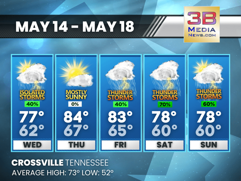
STORM CHANCES BUILD THROUGH WEEKEND
Spotty showers midweek give way to increasing thunderstorm risk Friday through Sunday. Wednesday: A slight chance of showers, then a chance of showers and thunderstorms after 1pm. Partly sunny, wit ...
STORMY START, SUMMER FINISH
Unsettled weather through Friday with thunderstorms likely — calmer, warmer pattern takes hold by the weekend. Monday: Showers likely and possibly a thunderstorm before 9am, then a chance of shower ...

SEVERE THUNDERSTORMS SLAM PARTS OF EAST AND MIDDLE TN THURSDAY AFTERNOON
A series of severe thunderstorms swept across portions of East and Middle Tennessee Thursday afternoon, prompting multiple warnings from the National Weather Service offices in Morristown and Nashvill ...

SEVERE THUNDERSTORM WATCH EXPANDED TO EAST TN
The National Weather Service has issued a Severe Thunderstorm Watch for much of East Tennessee, effective until 11:00 PM EDT Thursday, May 8, 2025. Areas under the watch include Knoxville, Chattanooga ...

SEVERE THUNDERSTORM WATCH ISSUED
A Severe Thunderstorm Watch is in effect until 8:00 PM CDT Thursday, May 8, 2025, for much of Middle Tennessee and southern Kentucky, including the city of Crossville. The watch area also includes Nas ...

SEVERE STORMS POSSIBLE THURSDAY WITH DAMAGING WINDS AND LARGE HAIL
The National Weather Service is monitoring a developing severe weather threat for Thursday, May 8, across parts of the Tennessee Valley and Southern Appalachians. A Slight Risk (Level 2 out of 5) for ...

SEVERE STORMS POSSIBLE THURSDAY WITH HAIL AND DAMAGING WINDS
Unsettled weather will continue through Monday, with daily chances for rain and high temperatures ranging from the 60s to low 70s. Thursday: Showers and thunderstorms likely, then showers and possi ...
SUNSHINE FADES AS SHOWERS RETURN MIDWEEK
Calm, mild start gives way to increasing clouds and rain chances from Wednesday through Saturday. Tuesday: Mostly sunny, with a high near 69. Calm wind becoming west around 5 mph in the morning. ...
COOL START TO THE WEEK WITH PATCHY FOG AND SCATTERED SHOWERS
Rain chances build midweek, with highs climbing from the 60s into the low 70s by Thursday. Monday: A chance of showers and thunderstorms. Patchy fog before 9am. Otherwise, partly su ...
WET WEEKEND AHEAD WITH THUNDERSTORMS LIKELY
Scattered storms begin today, with widespread rain and possible thunder Saturday; gradual clearing returns by Monday. Today: A 40 percent chance of showers and thunderstorms after 1 ...

THUNDERSTORM WATCH IN EFFECT UNTIL 5
THE NATIONAL WEATHER SERVICE HAS ISSUED SEVERE THUNDERSTORM WATCH 209 IN EFFECT UNTIL 5 PM CDT THIS AFTERNOON FOR THE FOLLOWING AREAS IN TENNESSEE THIS WATCH INCLUDES 38 COUNTIES IN MIDDLE TENNESSEE B ...
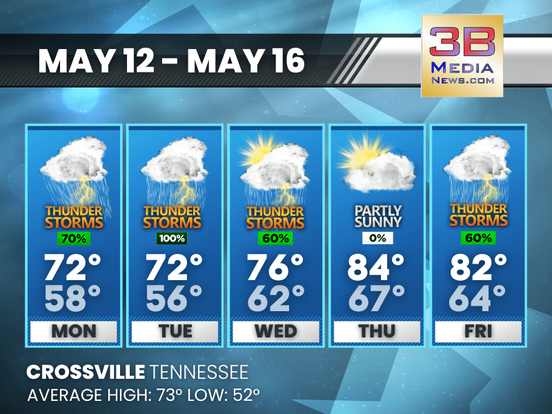
STORMY STRETCH AHEAD: THUNDERSTORMS LIKELY THROUGH SATURDAY
Rain chances ramp up Thursday afternoon and stay high through the weekend — gusty winds, downpours, and a few rumbles of thunder expected. Cooler by Sunday. Thursday: A slight chance of showers, th ...