

COOL AND CLOUDY TODAY, SUNNY AND WARMER BY MONDAY
Showers taper by afternoon with highs in the 50s—then sunshine returns and temps climb into the 70s to start the week. Today: A 50 percent chance
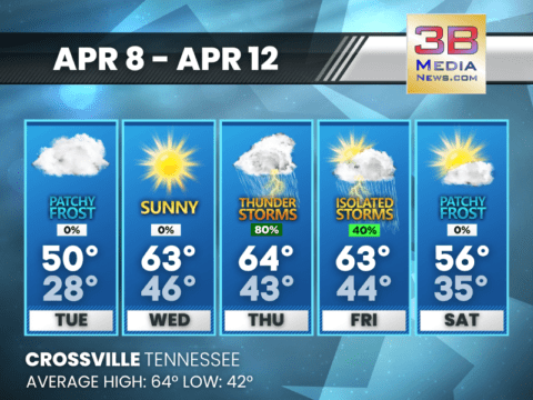
COOL START TO THE WEEK, WET BY THURSDAY
From frosty mornings to stormy afternoons—expect sunshine early in the week before rain and thunderstorms roll in late Thursday into Friday. Tuesday: Patchy frost before 8am.
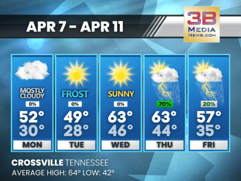
FROSTY NIGHTS, SUNNY DAYS — AND RAIN ON THE WAY
Cold mornings give way to midweek sunshine before rain and thunderstorms roll in Thursday. Today: Mostly cloudy, with a high near 52. North northwest wind 5

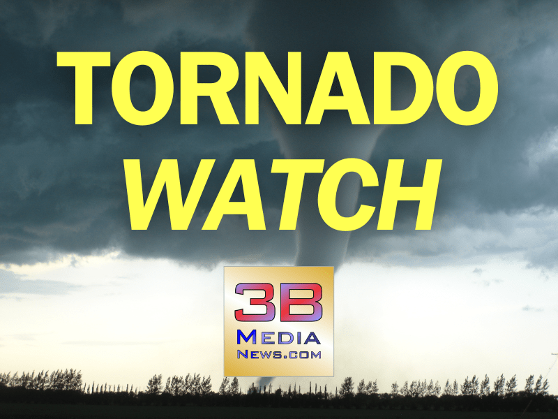
TORNADO WATCH ISSUED OVERNIGHT FOR PARTS OF EAST TENNESSEE
The National Weather Service has issued Tornado Watch 130 in effect until 7 a.m. Eastern (6 a.m. Central) this morning for several counties in East
TORNADO WATCH EXTENDED TO INCLUDE CUMBERLAND COUNTY
The National Weather Service has extended Tornado Watch 128 to include Cumberland County in Middle Tennessee until 3 a.m. CDT Sunday. This extension places the

TORNADO WATCH EXTENDED FOR FENTRESS AND PICKETT COUNTIES
The National Weather Service has extended Tornado Watch 124 to include parts of Middle Tennessee, with Fentress and Pickett counties now under the watch through

TORNADO WATCH ISSUED FOR MIDDLE TN
The National Weather Service has issued Tornado Watch #124 for a large portion of Middle Tennessee and parts of southern Kentucky and northern Alabama, in
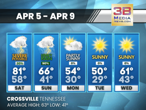
SEVERE STORMS, THEN A COLD SNAP: WILD WEEKEND WEATHER AHEAD
From 80s to 30s—thunderstorms, heavy rain, and plunging temps mark a dramatic shift starting Saturday. Saturday: A slight chance of showers before 1pm, then a slight

FLASH FLOOD WARNING FOR NORTHWESTERN PICKETT COUNTY
BULLETIN – EAS ACTIVATION REQUESTED Flash Flood Warning National Weather Service Nashville TN 200 PM CDT Thu Apr 3 2025 The National Weather Service in

NEW TORNADO WATCH ISSUED FOR PICKETT, FENTRESS
A Tornado Watch has been issued for parts of Arkansas, Kentucky, Mississippi, and Tennessee, including Pickett and Fentress Counties in Tennessee. The watch is in

NEW SEVERE THUNDERSTORM WARNING FOR PICKETT, FENTRESS
BULLETIN – IMMEDIATE BROADCAST REQUESTED Severe Thunderstorm Warning National Weather Service Nashville TN 611 AM CDT Thu Apr 3 2025 The National Weather Service in

SEVERE THUNDERSTORM WARNING FOR FENTRESS, PICKETT
BULLETIN – IMMEDIATE BROADCAST REQUESTED Severe Thunderstorm Warning National Weather Service Nashville TN 6:03 AM CDT Thu Apr 3 2025 The National Weather Service in

COOL AND CLOUDY TODAY, SUNNY AND WARMER BY MONDAY
Showers taper by afternoon with highs in the 50s—then sunshine returns and temps climb into the 70s to start the week. Today: A 50 percent chance of showers, mainly between 8am and 3pm. Mostly clou ...

COOL START TO THE WEEK, WET BY THURSDAY
From frosty mornings to stormy afternoons—expect sunshine early in the week before rain and thunderstorms roll in late Thursday into Friday. Tuesday: Patchy frost before 8am. Otherwise, mostly clou ...

FROSTY NIGHTS, SUNNY DAYS — AND RAIN ON THE WAY
Cold mornings give way to midweek sunshine before rain and thunderstorms roll in Thursday. Today: Mostly cloudy, with a high near 52. North northwest wind 5 to 10 mph, with gusts as high as 20 mph. ...

TORNADO WATCH ISSUED OVERNIGHT FOR PARTS OF EAST TENNESSEE
The National Weather Service has issued Tornado Watch 130 in effect until 7 a.m. Eastern (6 a.m. Central) this morning for several counties in East Tennessee. The watch includes Bledsoe, Blount, Loudo ...
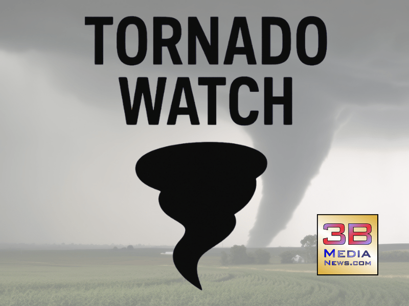
TORNADO WATCH EXTENDED TO INCLUDE CUMBERLAND COUNTY
The National Weather Service has extended Tornado Watch 128 to include Cumberland County in Middle Tennessee until 3 a.m. CDT Sunday. This extension places the city of Crossville under the watch as th ...

TORNADO WATCH EXTENDED FOR FENTRESS AND PICKETT COUNTIES
The National Weather Service has extended Tornado Watch 124 to include parts of Middle Tennessee, with Fentress and Pickett counties now under the watch through 9:00 PM Central Daylight Time this even ...

TORNADO WATCH ISSUED FOR MIDDLE TN
The National Weather Service has issued Tornado Watch #124 for a large portion of Middle Tennessee and parts of southern Kentucky and northern Alabama, in effect until 9:00 PM CDT on Saturday, April 5 ...
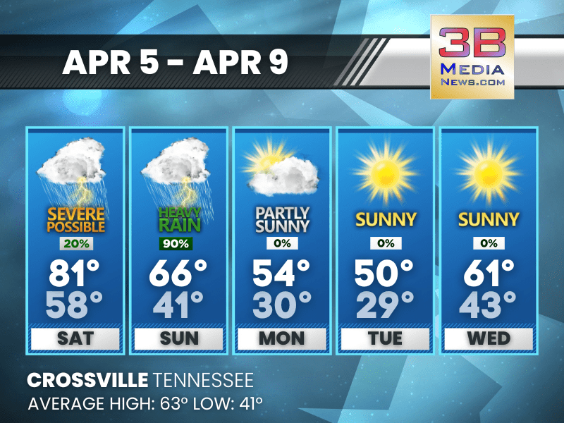
SEVERE STORMS, THEN A COLD SNAP: WILD WEEKEND WEATHER AHEAD
From 80s to 30s—thunderstorms, heavy rain, and plunging temps mark a dramatic shift starting Saturday. Saturday: A slight chance of showers before 1pm, then a slight chance of showers and thunderst ...

FLASH FLOOD WARNING FOR NORTHWESTERN PICKETT COUNTY
BULLETIN - EAS ACTIVATION REQUESTED Flash Flood Warning National Weather Service Nashville TN 200 PM CDT Thu Apr 3 2025 The National Weather Service in Nashville has issued a Flash Flood Warning ...
NEW TORNADO WATCH ISSUED FOR PICKETT, FENTRESS
A Tornado Watch has been issued for parts of Arkansas, Kentucky, Mississippi, and Tennessee, including Pickett and Fentress Counties in Tennessee. The watch is in effect until 10:00 PM CDT Thursday, A ...

NEW SEVERE THUNDERSTORM WARNING FOR PICKETT, FENTRESS
BULLETIN - IMMEDIATE BROADCAST REQUESTED Severe Thunderstorm Warning National Weather Service Nashville TN 611 AM CDT Thu Apr 3 2025 The National Weather Service in Nashville has issued a Severe ...

SEVERE THUNDERSTORM WARNING FOR FENTRESS, PICKETT
BULLETIN - IMMEDIATE BROADCAST REQUESTED Severe Thunderstorm Warning National Weather Service Nashville TN 6:03 AM CDT Thu Apr 3 2025 The National Weather Service in Nashville has issued a Sever ...