

BLUSTERY THURSDAY BRINGS SNOW CHANCES
Windy conditions Thursday transition to light snow and sleet overnight. Frost dominates the weekend, with sunny skies and highs near 50 on Saturday and near
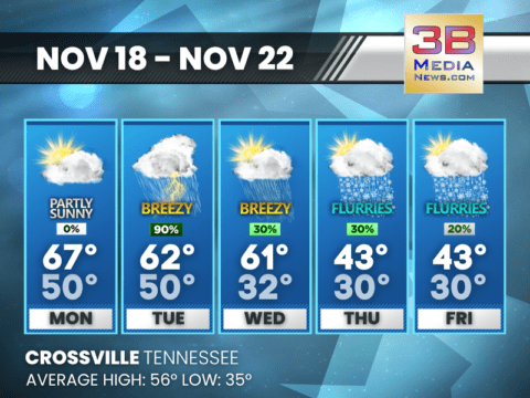
MILD START GIVES WAY TO COOL TEMPS
Patchy fog and mild weather kick off Monday, but rain and thunderstorms dominate Tuesday. Temperatures drop sharply midweek, with a mix of rain and snow
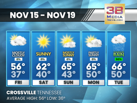
COOL AND CALM WEATHER THIS WEEKEND
Mostly sunny skies and mild highs in the 60s dominate the weekend, with calm winds and partly cloudy nights. Rain chances increase early next week,
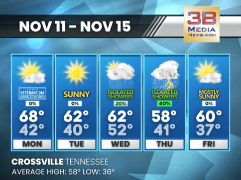
VETERANS DAY: MORNING CLOUDS, AFTERNOON SUN
Highs near 68° today with gradual clearing, but rain chances increase Wednesday night into Thursday, bringing cooler, stormy conditions. Veterans Day: Mostly cloudy through mid morning,
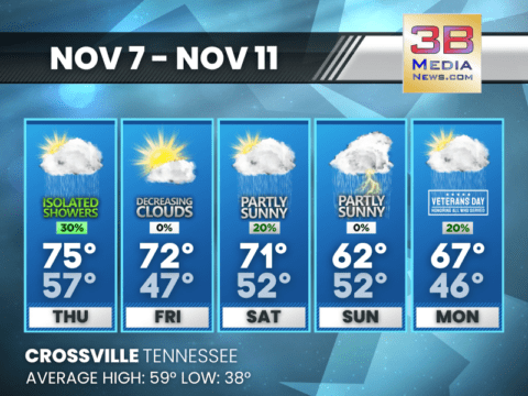
RAIN AND GUSTY WINDS AHEAD THIS WEEKEND
Widespread fog and a chance of rain today give way to sunny breaks Friday. Rain and thunderstorms return Saturday night through Sunday, with some clearing
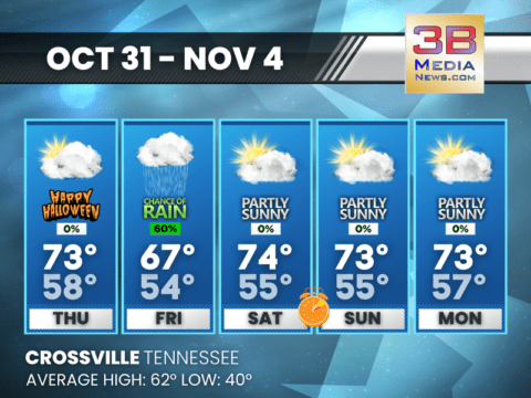
CLOUDS AND SHOWERS ON HALLOWEEN
Look for gusty winds and showers on Halloween night, with patchy fog and a partly sunny weekend as clocks turn back on Sunday. Thursday: Mostly
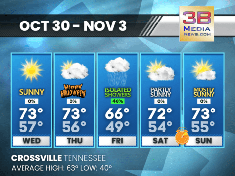
A MIXED BAG AHEAD FOR HALLOWEEN WEEK
Expect mostly cloudy skies and mild temperatures, with daylight saving time ending this weekend. Wednesday: Mostly cloudy, then gradually becoming sunny, with a high near 73.

DROUGHT UPDATE
According to new data released this morning, drought conditions remain unchanged across Cumberland County this week. The northern portion of the county is under abnormally
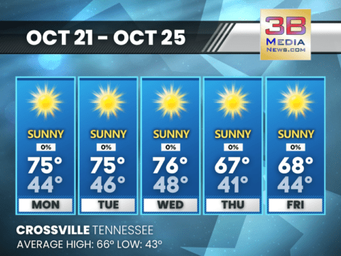
SUNNY, MILD DAYS AHEAD WITH CLEAR, COOL NIGHTS
Temperatures rise to the high 70s by Friday, with light winds and mostly clear skies throughout the weekend. Cooler evenings bring lows in the 40s.
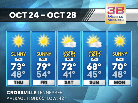
SUNNY AND MILD WEEK AHEAD
Patchy morning fog to clear early Monday, leading to pleasant days with highs in the mid-70s. Expect cool, crisp nights dipping into the 40s through
CHILLY MORNINGS WITH WIDESPREAD FROST
Expect frosty conditions early in the week, with temperatures dipping to the low 30s before warming to sunny highs near 70 by the weekend. Wednesday: Widespread
CHILLY NIGHTS AND FROSTY MORNINGS AHEAD
Temperatures drop into the 30s starting Tuesday night, with frost likely across northern areas and the Cumberland Plateau. Prepare for freezing conditions in higher elevations,
BLUSTERY THURSDAY BRINGS SNOW CHANCES
Windy conditions Thursday transition to light snow and sleet overnight. Frost dominates the weekend, with sunny skies and highs near 50 on Saturday and near 60 by Sunday. Showers return early next wee ...

MILD START GIVES WAY TO COOL TEMPS
Patchy fog and mild weather kick off Monday, but rain and thunderstorms dominate Tuesday. Temperatures drop sharply midweek, with a mix of rain and snow showers possible by Thursday. Monday: Patchy ...

COOL AND CALM WEATHER THIS WEEKEND
Mostly sunny skies and mild highs in the 60s dominate the weekend, with calm winds and partly cloudy nights. Rain chances increase early next week, peaking on Tuesday. Friday: Mostly cloudy, with a ...

VETERANS DAY: MORNING CLOUDS, AFTERNOON SUN
Highs near 68° today with gradual clearing, but rain chances increase Wednesday night into Thursday, bringing cooler, stormy conditions. Veterans Day: Mostly cloudy through mid morning, then gradua ...

RAIN AND GUSTY WINDS AHEAD THIS WEEKEND
Widespread fog and a chance of rain today give way to sunny breaks Friday. Rain and thunderstorms return Saturday night through Sunday, with some clearing by Veterans Day. Today: A chance of shower ...

CLOUDS AND SHOWERS ON HALLOWEEN
Look for gusty winds and showers on Halloween night, with patchy fog and a partly sunny weekend as clocks turn back on Sunday. Thursday: Mostly cloudy, with a high near 73. South wind around 15 mph ...

A MIXED BAG AHEAD FOR HALLOWEEN WEEK
Expect mostly cloudy skies and mild temperatures, with daylight saving time ending this weekend. Wednesday: Mostly cloudy, then gradually becoming sunny, with a high near 73. South wind 5 to 10 mph ...

DROUGHT UPDATE
According to new data released this morning, drought conditions remain unchanged across Cumberland County this week. The northern portion of the county is under abnormally dry conditions with moderate ...

SUNNY, MILD DAYS AHEAD WITH CLEAR, COOL NIGHTS
Temperatures rise to the high 70s by Friday, with light winds and mostly clear skies throughout the weekend. Cooler evenings bring lows in the 40s. Today: Sunny, with a high near 73. North northeas ...

SUNNY AND MILD WEEK AHEAD
Patchy morning fog to clear early Monday, leading to pleasant days with highs in the mid-70s. Expect cool, crisp nights dipping into the 40s through Friday. Monday: Patchy fog before 8am. Otherwise ...

CHILLY MORNINGS WITH WIDESPREAD FROST
Expect frosty conditions early in the week, with temperatures dipping to the low 30s before warming to sunny highs near 70 by the weekend. Wednesday: Widespread frost, mainly before 8am. Otherwise, ...

CHILLY NIGHTS AND FROSTY MORNINGS AHEAD
Temperatures drop into the 30s starting Tuesday night, with frost likely across northern areas and the Cumberland Plateau. Prepare for freezing conditions in higher elevations, and protect plants and ...