

TENNESSEE BRACES FOR WINTER WEATHER: SNOW POSSIBLE IN HIGHER ELEVATIONS TONIGHT
State agencies and local agencies across Tennessee are gearing up for winter weather this evening into the overnight hours. As the week brings a sharp

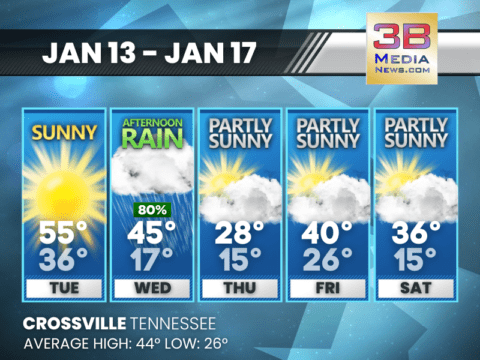
MIDWEEK RAIN GIVES WAY TO A COLDER, BRIGHTER FINISH
Rain clears out Wednesday, followed by a steady cool-down and increasing sunshine through the weekend. Today: Rain before 5pm, then a chance of rain and snow.
RAIN CHANGING TO SNOW LATE WEDNESDAY AFTERNOON AND EVENING
Posted by Roane County Emergency Alerts: …Rain Changing to Snow Late Wednesday Afternoon and Evening… A cold front will move across east Tennessee, southwest Virginia,
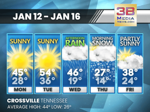
ARCTIC BLAST RETURNS AFTER MIDWEEK RAIN
A warm and sunny Tuesday gives way to afternoon rain Wednesday before temperatures plunge into the teens with a stretch of cold, partly sunny days.
SUNNY OPEN TO THE WEEK BEFORE A MIDWEEK RAIN-TO-SNOW DROP
The pattern turns unsettled after Tuesday, shifting from afternoon rain Wednesday to morning snow Thursday. Monday: Sunny, with a high near 45. Calm wind becoming west
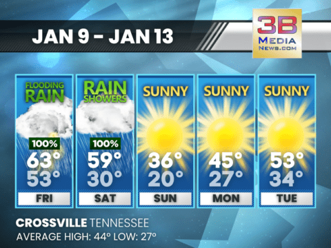
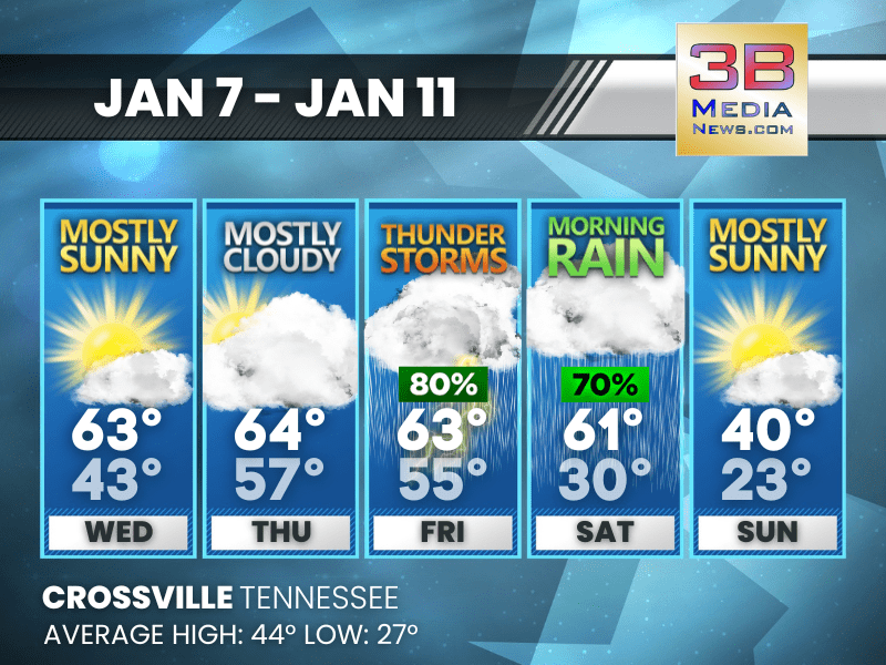
FLOODING RAIN FRIDAY, THEN A SHARP TURN TO COLD SUNSHINE
Rainfall ends Saturday before a much colder and brighter stretch moves in through early next week. Friday: Showers and thunderstorms before 3pm, then a chance of

HEAVY RAIN AND FLOODING THREATEN TENNESSEE THROUGH SATURDAY
A strong, slow-moving storm system will move across Tennessee beginning tonight and lasting through Saturday, bringing periods of heavy rain, flooding, and a low but

FLOOD WATCH ISSUED FOR SEVERAL LOCAL COUNTIES INCLUDING CUMBERLAND AND FENTRESS
A flash flood watch has been issued for portions of Middle Tennessee, including counties such as Bedford, Cannon, Clay, Coffee, Cumberland, Davidson, De Kalb, Fentress,
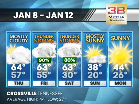
STORMS LATE WEEK FOLLOWED BY A SHARP WEEKEND COOL-DOWN
Crossville faces thunderstorms Friday and Saturday before temperatures crash into the 30s and 20s by Sunday. Thursday: Mostly cloudy, with a high near 64. South wind

FLOODING RISK, ISOLATED STRONG STORMS POSSIBLE FRIDAY
A large storm system moving east across the region will bring periods of rain, gusty winds, and a low-end threat for a few strong to

MIDWEEK WARMTH GIVES WAY TO STORMS AND A SHARP COOL-DOWN
Mild temperatures continue midweek before thunderstorms Friday and much colder air arrives for the weekend. Wednesday: Patchy fog between 8am and 9am. Otherwise, mostly sunny, with
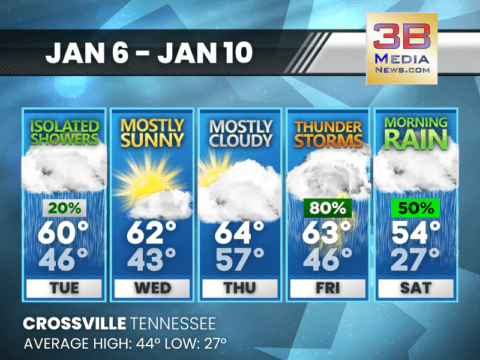
MILD JANUARY STRETCH WITH RAIN CHANCES LATE WEEK
Above-average temperatures continue through the week, with increasing rain and a chance of thunderstorms by Friday before cooler rain arrives Saturday. Tuesday: A slight chance of

TENNESSEE BRACES FOR WINTER WEATHER: SNOW POSSIBLE IN HIGHER ELEVATIONS TONIGHT
State agencies and local agencies across Tennessee are gearing up for winter weather this evening into the overnight hours. As the week brings a sharp plunge in temperatures and the possibility of sno ...
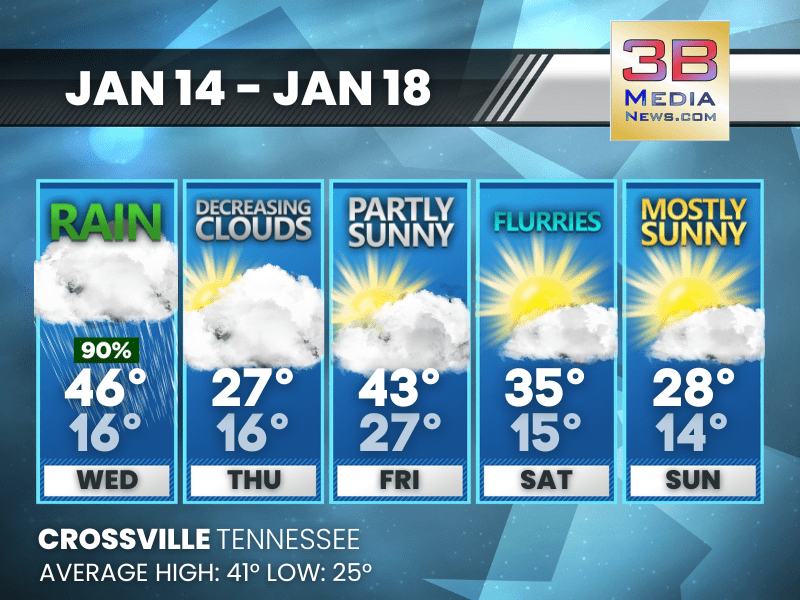
MIDWEEK RAIN GIVES WAY TO A COLDER, BRIGHTER FINISH
Rain clears out Wednesday, followed by a steady cool-down and increasing sunshine through the weekend. Today: Rain before 5pm, then a chance of rain and snow. High near 46. Southwest wind 5 to 10 m ...

RAIN CHANGING TO SNOW LATE WEDNESDAY AFTERNOON AND EVENING
Posted by Roane County Emergency Alerts: ...Rain Changing to Snow Late Wednesday Afternoon and Evening... A cold front will move across east Tennessee, southwest Virginia, and southwest North ...

ARCTIC BLAST RETURNS AFTER MIDWEEK RAIN
A warm and sunny Tuesday gives way to afternoon rain Wednesday before temperatures plunge into the teens with a stretch of cold, partly sunny days. Tuesday: Sunny, with a high near 55. Southwest wi ...

SUNNY OPEN TO THE WEEK BEFORE A MIDWEEK RAIN-TO-SNOW DROP
The pattern turns unsettled after Tuesday, shifting from afternoon rain Wednesday to morning snow Thursday. Monday: Sunny, with a high near 45. Calm wind becoming west around 5 mph. Monday Night ...
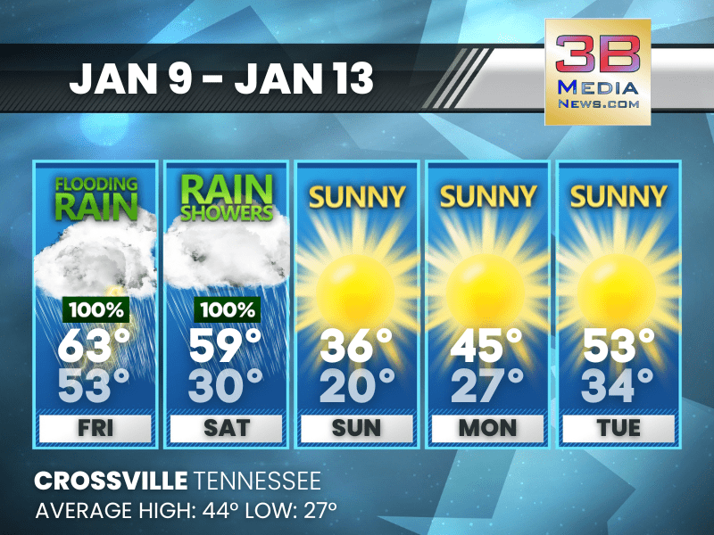
FLOODING RAIN FRIDAY, THEN A SHARP TURN TO COLD SUNSHINE
Rainfall ends Saturday before a much colder and brighter stretch moves in through early next week. Friday: Showers and thunderstorms before 3pm, then a chance of showers. High near 63. South wind 1 ...

HEAVY RAIN AND FLOODING THREATEN TENNESSEE THROUGH SATURDAY
A strong, slow-moving storm system will move across Tennessee beginning tonight and lasting through Saturday, bringing periods of heavy rain, flooding, and a low but notable risk for strong thundersto ...

FLOOD WATCH ISSUED FOR SEVERAL LOCAL COUNTIES INCLUDING CUMBERLAND AND FENTRESS
A flash flood watch has been issued for portions of Middle Tennessee, including counties such as Bedford, Cannon, Clay, Coffee, Cumberland, Davidson, De Kalb, Fentress, Giles, Grundy, Hickman, Jackson ...
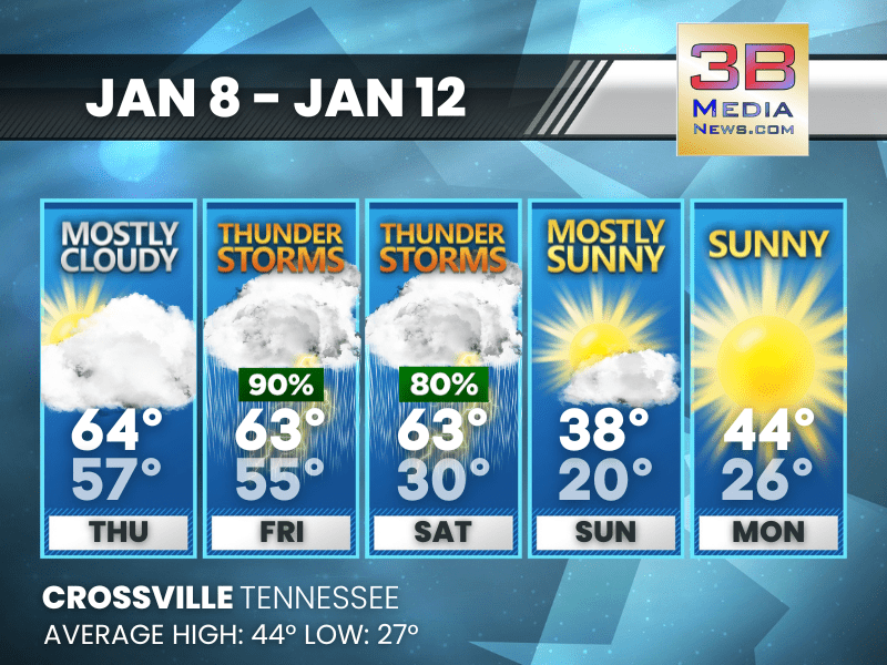
STORMS LATE WEEK FOLLOWED BY A SHARP WEEKEND COOL-DOWN
Crossville faces thunderstorms Friday and Saturday before temperatures crash into the 30s and 20s by Sunday. Thursday: Mostly cloudy, with a high near 64. South wind 5 to 10 mph, with gusts as high ...

FLOODING RISK, ISOLATED STRONG STORMS POSSIBLE FRIDAY
A large storm system moving east across the region will bring periods of rain, gusty winds, and a low-end threat for a few strong to severe thunderstorms across Tennessee on Friday. While the severe w ...
MIDWEEK WARMTH GIVES WAY TO STORMS AND A SHARP COOL-DOWN
Mild temperatures continue midweek before thunderstorms Friday and much colder air arrives for the weekend. Wednesday: Patchy fog between 8am and 9am. Otherwise, mostly sunny, with a high near 63. ...
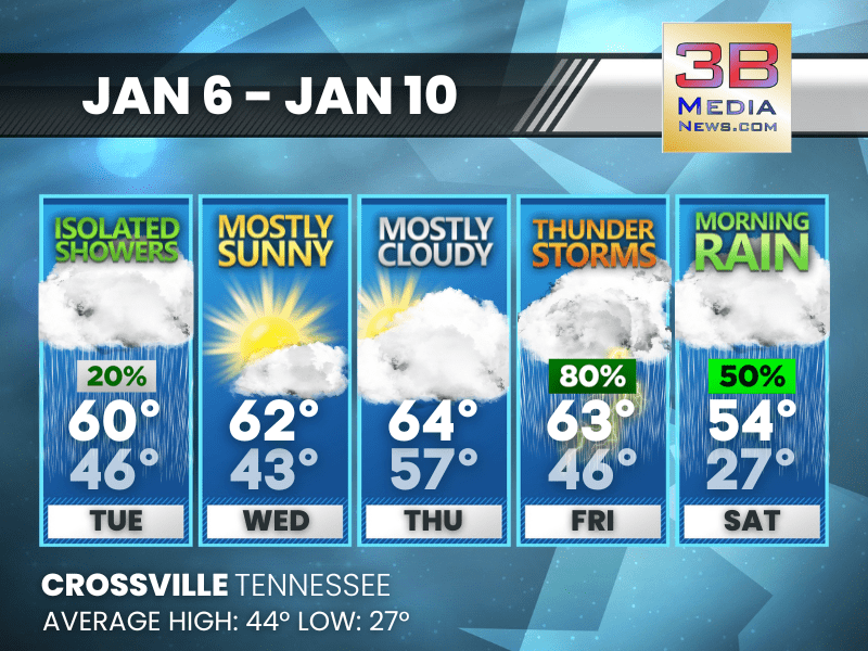
MILD JANUARY STRETCH WITH RAIN CHANCES LATE WEEK
Above-average temperatures continue through the week, with increasing rain and a chance of thunderstorms by Friday before cooler rain arrives Saturday. Tuesday: A slight chance of showers between 7 ...