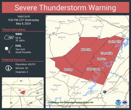
SEVERE THUNDERSTORM WARNING
BULLETIN – EAS ACTIVATION REQUESTED
Severe Thunderstorm Warning
National Weather Service Morristown TN
853 PM EDT Wed May 8 2024
The National Weather Service in Morristown has issued a
* Severe Thunderstorm Warning for…
Rhea County in east Tennessee…
Southwestern Meigs County in east Tennessee…
Northern Sequatchie County in east Tennessee…
Bledsoe County in east Tennessee…
Northeastern Hamilton County in east Tennessee…
* Until 1000 PM EDT/900 PM CDT/.
* At 852 PM EDT/752 PM CDT/, a severe thunderstorm was located near
McMinnville, moving southeast at 40 mph.
HAZARD…Two inch hail and 70 mph wind gusts.
SOURCE…Radar indicated.
IMPACT…People and animals outdoors will be injured. Expect hail
damage to roofs, siding, windows, and vehicles. Expect
considerable tree damage. Wind damage is also likely to
mobile homes, roofs, and outbuildings.
* Locations impacted include…
Dayton, Dunlap, Pikeville, Soddy-Daisy, Spring City, Graysville,
Flat Top Mountain, Stinging Fork Falls State Park, Piney Falls
State Park, and Mount Crest.
PRECAUTIONARY/PREPAREDNESS ACTIONS…
For your protection move to an interior room on the lowest floor of a
building.
A Tornado Watch remains in effect until midnight EDT/1100 PM CDT/ for
east Tennessee.
&&
LAT…LON 3555 8546 3557 8542 3572 8526 3576 8527
3577 8525 3577 8504 3575 8503 3577 8494
3576 8492 3579 8486 3576 8476 3575 8475
3522 8499 3538 8549 3541 8549 3541 8551
3542 8551 3543 8554 3549 8554 3553 8560
TIME…MOT…LOC 0052Z 296DEG 36KT 3560 8576
THUNDERSTORM DAMAGE THREAT…CONSIDERABLE
HAIL THREAT…RADAR INDICATED
MAX HAIL SIZE…2.00 IN
WIND THREAT…RADAR INDICATED
MAX WIND GUST…70 MPH