TORNADO WARNING
BULLETIN – EAS ACTIVATION REQUESTED
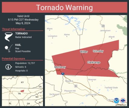
Tornado Warning
National Weather Service Nashville TN
746 PM CDT Wed May 8 2024
The National Weather Service in Nashville has issued a
* Tornado Warning for…
Southeastern Overton County in Middle Tennessee…
North central Cumberland County in Middle Tennessee…
East central Putnam County in Middle Tennessee…
Southwestern Fentress County in Middle Tennessee…
* Until 815 PM CDT.
* At 745 PM CDT, a severe thunderstorm capable of producing a tornado
was located near Monterey, or 15 miles south of Livingston, moving
east at 45 mph.
HAZARD…Tornado.
SOURCE…Radar indicated rotation.
IMPACT…Flying debris will be dangerous to those caught without
shelter. Mobile homes will be damaged or destroyed.
Damage to roofs, windows, and vehicles will occur. Tree
damage is likely.
* This tornadic thunderstorm will remain over mainly rural areas of
southeastern Overton, north central Cumberland, east central Putnam
and southwestern Fentress Counties, including the following
locations… Crawford, Grimsley, and Clarkrange.
This includes Interstate 40 between mile markers 300 and 303.
PRECAUTIONARY/PREPAREDNESS ACTIONS…
TAKE COVER NOW! Move to a basement or an interior room on the lowest
floor of a sturdy building. Avoid windows. If you are outdoors, in a
mobile home, or in a vehicle, move to the closest substantial shelter
and protect yourself from flying debris.
&&
LAT…LON 3611 8529 3625 8533 3637 8483 3630 8483
3629 8484 3629 8487 3628 8488 3624 8488
3624 8489 3621 8491 3618 8490 3615 8491
3613 8487 3610 8484 3609 8482
TIME…MOT…LOC 0045Z 254DEG 40KT 3619 8523
TORNADO…RADAR INDICATED
MAX HAIL SIZE…<.75 IN