
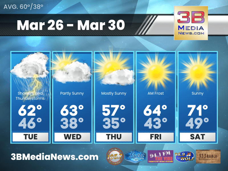
TUESDAY’S 5-DAY FORECAST
Seasonally warm conditions will continue to prevail through Tuesday afternoon.
Tuesday: Showers and possibly a thunderstorm before 1pm, then showers likely. High near 60. South wind 15 to 20 mph, with gusts as high as 40 mph. Chance of precipitation is 80%. New precipitation amounts between a half and three quarters of an inch possible.
Tuesday Night: A 20 percent chance of showers. Mostly cloudy, with a low around 46. South wind 5 to 15 mph becoming west after midnight. Winds could gust as high as 20 mph.
Wednesday: Partly sunny, with a high near 63. West northwest wind 5 to 10 mph.
Wednesday Night: Mostly cloudy, with a low around 38. North wind 10 to 15 mph.
Thursday: Mostly sunny, with a high near 57. North wind around 15 mph, with gusts as high as 20 mph.
Thursday Night: Areas of frost after 4am. Otherwise, clear, with a low around 35. North northwest wind 5 to 15 mph.
Friday: Areas of frost before 8am. Otherwise, sunny, with a high near 64. West northwest wind 5 to 10 mph.
Friday Night: Mostly clear, with a low around 43.
Saturday: Sunny, with a high near 71.
Saturday Night: Mostly clear, with a low around 49.
Almanac for Crossville, Tennessee for March 26, 2024:
- Normal High Temperature: 60
- Normal Low Temperature: 38
- Record High Temperature: 80 in 2007
- Record Low Temperature: 11 in 1955
- Sunrise: 6:34 AM CDT
- Sunset: 6:58 PM CDT
- Next Full Moon: Tuesday, April 23, 2024 at 6:49 PM CDT (Pink Moon)
- Summer Equinox: Thursday, June 20 2024 at 3:50 PM CDT
Weather information is provided by the National Weather Service in Nashville. Hear the latest forecast on 105.7 The Hog, 94.1 The Vibe, Spirit 101.9, 98.9 The Wolf, and 93.3 The Ranch.