

ANALYZING THE FIRE THAT BURNED INTO GATLINBURG
Above: The Drought Monitor issued November 29 showed “Exceptional Drought”, the highest category, for the Gatlinburg area and large sections of Tennessee, Georgia, Alabama, North Carolina, and South Carolina.
On Monday, December 5, the Incident Management Team (IMT) on the Chimney Tops 2 Fire that burned from Great Smoky Mountains National Park (GRSM) into the Gatlinburg area reported that it has caused the deaths of 14 people. Over 130 sustained injuries, and 1,684 structures have been damaged or destroyed. Approximately 14,000 residents were originally forced to evacuate.
There are three broad categories of conditions that affect the way a wildfire burns: weather, fuels (vegetation), and topography. When the Chimney Tops 2 Fire burned into Gatlinburg on November 28, 2016 and destroyed those structures it was driven primarily by weather — specifically, very strong winds.
But the condition of the fuel was also important since it happened during what the National Weather Service (NWS) calls “exceptional drought” conditions. Much of the southeastern United States had been suffering extremely dry conditions for two to three months.
One indicator of drought and its effect on how wildfires burn is the Keetch-Byram Drought Index (KBDI). (The fire was in eastern Tennessee near the North Carolina border.)

On November 23 when the fire was discovered the KBDI was 599, Molly Schroer, a spokesperson for the IMT told us. For reference, 600 or above would indicate severe drought and increased wildfire occurrence. Intense, deep burning fires with significant downwind spotting should be expected. A fire burning under those conditions would likely burn more intensely, have a rate of spread faster than normal, and have more resistance to control. Many fire managers in that situation would immediately attack emerging fires very aggressively with overwhelming force, that is, many firefighters on the ground assisted by numerous aircraft dropping water or fire retardant.
Ms. Schroer said she was not aware of any actual on-the-ground fire suppression efforts, other than perhaps some work on a distant indirect fireline, until Monday November 28, after the fire had grown large and crossed US Highway 141, the main road into the park. That is when it began moving rapidly toward Gatlinburg. Firefighting aircraft were not used until helicopters dropped water on the fire Sunday afternoon, November 27 four days after it started.
Wednesday, November 23, the day the fire started
At about 5:20 p.m. the fire was discovered near the top of a steep hill called Chimney Tops not far from where another fire occurred about a week before. GRSM firefighters spotted the new fire as they returned from responding to a report of a vehicle fire. The earlier fire on the hill was named “Chimney Tops” — hence the name “Chimney Tops 2” for the new blaze.
According to Ms. Schroer, firefighters walked up the Chimney Tops Trail to the top of the hill to size it up. But very little if any fire suppression activity occurred until Monday, November 28. The action taken by firefighters on Monday was defensive, to protect threatened structures at a nearby National Park Service picnic ground.
Investigators have determined that the fire was human-caused and are asking for information from anyone who has information about people or vehicles that were seen in the area that day. The Tip Line is 888-653-0009.
Narrowing it down to human-causes is easy for an investigator. It means they eliminated natural causes, such as lightning and volcano eruptions. The fire could have been accidental, or it may have been intentional.

The fire occurred in the Autumn after the deciduous trees had shed their leaves adding more fuel to the forest floor that was already abundant with desiccated leaves, twigs, dead branches, and logs that had been sucked dry of their moisture by the months of drought. The leafless trees allowed more sunlight to hit the fuel, drying it out even more.
Thursday, Thanksgiving, November 24
The day after the fire was reported 0.12 inch of rain was recorded at the official weather station recognized by the NWS, which may have made the managers of Great Smoky Mountains National Park (GRSM) feel a little better about this new fire. Only 0.05 inch fell at the Indian Grave Remote Automatic Weather Station 18 miles west of the fire. Neither was enough rain to halt the drought, of course, nor was it enough to have an extended effect on the the Chimney Tops 2 Fire.
Citing the steep terrain and the safety of firefighters, fire managers at Great Smoky Mountains National Park (GRSM) decided not to take direct action on the fire which would entail constructing fireline along the edge of the fire to remove the fuel that allows it to spread. They decided instead to monitor and to identify on a map areas for indirect containment lines which encompassed 410 acres. Some of the drainages where the managers hoped to stop the fire were a half mile away.
Saturday, November 26
The fire was approximately 8 acres in size, according to GRSM.
Sunday, November 27
Sunday, four days after the fire started, was the first time that any firefighting aircraft were used on the fire, Ms. Schroer said. That afternoon a Chinook Type 1 helicopter (Type 1’s are the largest helicopters used on wildfires) began dropping water on the fire, refilling at Fontana Lake 13 miles to the southwest, according to a source we talked to who didn’t want their name disclosed because they were not authorized to speak on the subject. The helicopter worked until it had to refuel and then two other Type 1 helicopters took its place until dark. Sunset that day was at 5:21 p.m. which would have allowed them to drop on the fire until 5:51 p.m., 30 minutes after sunset.
Aircraft dropping water or fire retardant on a fire cannot put it out. Under ideal conditions they can temporarily slow the spread, which may be effective if firefighters on the ground can move in quickly to take advantage of the short term change in fire behavior by constructing firelines, stopping the spread at that location. In this case, there were no firefighters in a position to take direct action.
Ms. Schroer told us that additional firefighters were ordered on Sunday.

GRSM posted “Fire Information” signs in the area explaining their “monitoring” strategy due to “vertical cliffs, narrow rock ridges and steep drainages”. They had identified on a map a “410-acre fire management area which, depending on weather conditions, may allow for further fire growth”.
The “further fire growth” part was more accurate than they realized at the time.

A map posted with the Fire Information sign dated November 27 showed that the park hoped to stop the fire before it crossed the bottom of drainages on the west, north and east sides, and the Chimney Tops Trail to the south. On the map below, the fire is the small dot in the center surrounded by the yellow line.

On November 27 the fire was a third of a mile as the crow flies from US Highway 441. The terrain was steep, a vertical distance of 1,300 feet from the bottom of the drainages to the top of the hill. There were cliffs in the area but firefighting Hotshot Crews can figure out how to work on steep slopes, sometimes backing off a bit, constructing a fire line and intentionally burning the fuel in between, preventing further expansion of the fire. The Chimney Tops Trail led from the highway to the top of the hill.
Beginning at 2 a.m. on Sunday November 27 the relative humidity at Indian Grave dropped, getting as low as 17 percent at 8 a.m. and then lingering in the 20s and 30s until 4 am on Monday November 28. Those are low numbers for the southeastern United States. The wind speed was 1 to 3 mph.

Wildland firefighters typically request “Spot Weather Forecasts” from the NWS for wildland fires or other events that can be greatly influenced by weather. The forecasts are supposed to be detailed and customized predictions of the weather at a particular location, or “spot”, for at least the next two days.
We checked the Spot Weather Forecasts that were requested by the NPS and issued by the NWS for the Chimney Tops 2 Fire. Forecasts were issued each day from November 24 through 27; we could not find one for November 28 the day the fire burned into Gatlinburg. The forecasts from the 24th through the 26th did not predict the extreme weather that began Monday, November 28. But the last one, issued at 7 a.m. EST on Sunday by Eric Holweg, did predict strong winds. The GRSM person that requested the Spot wrote:
Concerned about ridgetop winds with the coming front. Thanks!
The forecast issued Sunday included this text in the Discussion section:
High pressure will hang on for Sunday with sunny skies and above normal temperatures. Increasing cloudiness and strong southerly winds on Monday ahead of the next storm system. Much needed rainfall is expected on Monday with additional rainfall possible through Wednesday.
An excerpt from that forecast is below.
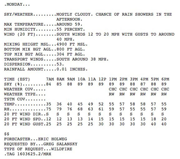
It predicted wind gusts out of the south Monday morning of 25 mph, increasing at noon to 30 mph and to 40 mph by 6 p.m. The fire was south of Gatlinburg.
By the end of the day on Sunday the fire had burned approximately 35 acres, according to Ms. Schroer and the results from a mapping flight (see the 3-D map above).
Monday, November 28
At 2 a.m. Monday the wind speeds recorded at Indian Grave began increasing and the direction became more consistently out of the south and southwest. Until 1 p.m. sustained speeds were 4 to 6 mph with gusts at 12 to 19 mph. Between 2 p.m. and 6 p.m. they increased to 7 to 15 mph with gusts of 22 to 32 mph — all generally out of the south, blowing toward Gatlinburg. From 7 p.m. until midnight sustained winds were at 13 to 17 mph with gusts from 34 to 49. This data from Indian Grave was not too far off the forecast issued the day before.
When maintenance employees with GRSM drove past the Chimney Tops 2 Fire early Monday morning they saw that the intensity and rate of spread of the fire had increased dramatically. It had burned into a picnic area and crossed the main road into the park, US Highway 441.
The wind and the low visibility caused by the smoke made it impossible to fly aircraft over the fire.
On-the-ground fire suppression activity took place Monday when firefighters took defensive action to protect structures at a nearby GRSM picnic area.
Late Monday afternoon the Gatlinburg Fire Department began informing some residents of a voluntary evacuation. Later it changed to a mandatory evacuation.
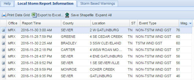
The Cove Mountain weather station is 8 miles northwest of the origin of the Chimney Tops 2 Fire, 5 miles west of downtown Gatlinburg, and 3 miles west of the last known western edge of the fire. Jim Renfro, the air quality specialist for GRSM, said the strongest wind gust recorded at Cove Mountain was 87 mph at 9 p.m. on Monday. Shortly after that power was lost to the station and data stopped being recorded.
Steve Brueck of DaculaWeather.com suppied us with Local Storm Report Information from the National Weather Service that includes wind gust speeds in the general area. Gatlinburg is in Sevier County. On Monday November 28 it recorded wind gusts in that part of the state at 46 to 60 mph, and a 76 mph gust on Wednesday.
Tuesday, November 29
Gusts above 40 continued until 2 a.m. on Tuesday when they mostly dropped below 20 mph for the rest of the day.

Rain began falling late Monday night and continued until 6 a.m. Tuesday, totaling 0.78 inch at Indian Grave. At the official Gatlinburg weather station recognized by the NWS 0.73 inch was recorded on Tuesday. This rain took much of the heat out of the vegetation fire and slowed the spread, but smoke from the burning structures in the communities and smouldering logs in the Park continued to fill the air.
Wednesday, November 30
The wind remained at moderate strength on Wednesday with gusts decreasing from 37 at 3 a.m. to the lower teens by the end of the day. When the rain started again at 8 a.m. the relative humidity rose into the 90s. Another 2.3 inches accumulated that day by the time it stopped at 7 p.m.
Monday, December 5
Since November 29 it has rained about every 2 to 3 days in the Gatlinburg area. The IMT reported that the fire had not increased in size over the previous 24 hours and was still listed at 17,006 acres. Firefighting resources assigned to the fire include 25 hand crews, 61 engines, 6 helicopters, and 2 dozers, for a total 780 personnel.
The status of individual structures in the Gatlinburg area can be found at arcgiscom.
Related Posts

ANDERSON COUNTY SCHOOL BOARD SAYS “NO” TO CONCEALED CARRY FOR TEACHERS
Scott Gillenwaters, School Board Chairman along with members of The Anderson County School Board, including…

TBI: ARSON AWARENESS WEEK FOCUSES ON PLACES OF WORSHIP
In recent years, an estimated average of 1,300 fires in places of worship were reported…

TENNESSEE CELEBRATES TEACHER APPRECIATION MONTH IN MAY
Throughout the month of May, the Tennessee Department of Education invites all Tennesseans to celebrate…