

BITTER COLD START, WARMER DAYS AND STORMS AHEAD
A frigid Sunday gives way to a steady warmup, ending with rain and thunderstorms late in the week. Sunday: A chance of flurries before 11am. Cloudy

DANGEROUS COLD GRIPS TENNESSEE AS MULTIPLE ADVISORIES REMAIN IN EFFECT
A dangerous stretch of cold weather is settling across much of Tennessee, prompting multiple Cold Weather Advisories from the National Weather Service that remain in
COLD START, BRIGHT DAYS AHEAD WITH A MIDWEEK WARMUP
Patchy fog gives way to sunshine Saturday, followed by a bitter cold snap, then a gradual return to milder temperatures by midweek. Saturday: Patchy fog before
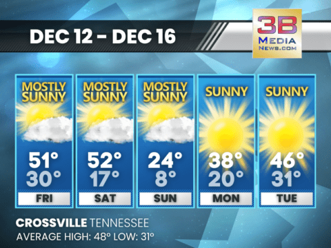
SUNSHINE NOW, SHARPLY COLDER BY SUNDAY
Mild afternoons give way to fog, gusty winds, and a bitter cold blast by the end of the weekend. Today: Mostly sunny, with a high near

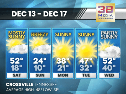
ARCTIC WEEKEND PLUNGE APPROACHES WITH BITTER COLD AND A CHANCE OF SNOW
A quiet stretch through Friday gives way to a sharp weekend cooldown, including a Saturday night chance for snow showers and single-digit lows by Sunday
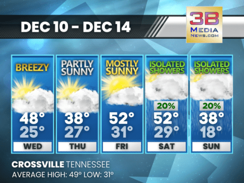
WINTER CHILL RETURNS MIDWEEK WITH GUSTY WINDS AND A LATE-WEEK WARMUP
A breezy, brisk stretch brings cold days and even colder nights before temperatures rebound heading into Friday, with a small chance of weekend showers. Wednesday: Partly
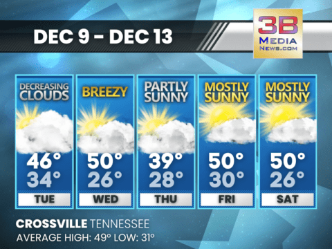
TURNS COLDER MIDWEEK BEFORE A LATE-WEEK WARMUP RETURNS
A mix of sun and clouds brings breezy conditions through midweek, followed by a colder Thursday and a gradual warming trend heading into the weekend.
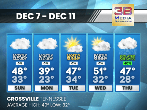
QUIET START TO THE WEEK BEFORE MIDWEEK SHOWERS RETURN
A mostly calm stretch gives way to increasing clouds and periodic showers from Wednesday night into Friday. Monday: A 20 percent chance of rain before 8am.
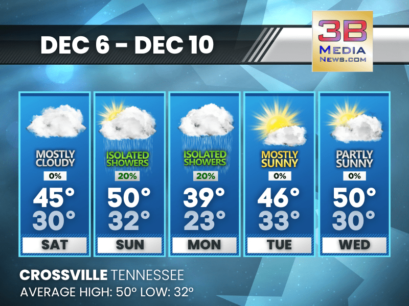
WEEK BEGINS COLD AND CLOUDY, THEN TURNS MILDER WITH MIDWEEK SHOWERS
A stretch of chilly, mostly cloudy days will gradually warm by midweek, with increasing chances for showers Wednesday night through Thursday. Sunday: Mostly cloudy, with a
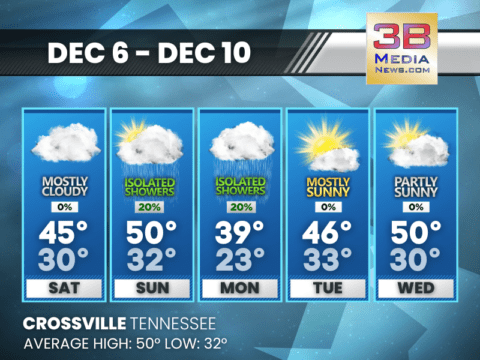
CLOUDS EARLY, SOME RAIN CHANCES RETURN MIDWEEK
Clearing arrives later today, fog builds in tonight, and scattered light rain chances move through Sunday and again by midweek before brighter weather returns. Today: Cloudy
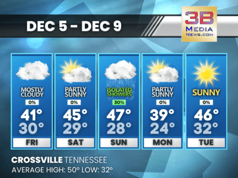
FOGGY STARTS AND COLDER NIGHTS LEAD INTO A CHILLY, MIXED-PRECIP WEEKEND
Fog returns at times through the weekend, with a brief chance of showers and freezing rain Sunday night before colder, calmer weather settles in early

SCHOOL CLOSINGS AND DELAYS FOR 12/05/25
The following schools will be closed Friday 12/5: Clay Overton Pickett Putnam Open but with a two hour delay: Cumberland Fentress Morgan Scott Oneida
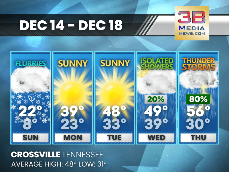
BITTER COLD START, WARMER DAYS AND STORMS AHEAD
A frigid Sunday gives way to a steady warmup, ending with rain and thunderstorms late in the week. Sunday: A chance of flurries before 11am. Cloudy through mid morning, then gradual clearing, with ...

DANGEROUS COLD GRIPS TENNESSEE AS MULTIPLE ADVISORIES REMAIN IN EFFECT
A dangerous stretch of cold weather is settling across much of Tennessee, prompting multiple Cold Weather Advisories from the National Weather Service that remain in effect through Monday. Forecasters ...
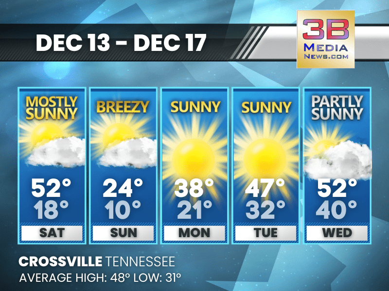
COLD START, BRIGHT DAYS AHEAD WITH A MIDWEEK WARMUP
Patchy fog gives way to sunshine Saturday, followed by a bitter cold snap, then a gradual return to milder temperatures by midweek. Saturday: Patchy fog before 9am. Otherwise, mostly sunny, with a ...
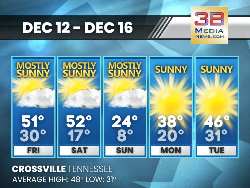
SUNSHINE NOW, SHARPLY COLDER BY SUNDAY
Mild afternoons give way to fog, gusty winds, and a bitter cold blast by the end of the weekend. Today: Mostly sunny, with a high near 51. South wind 5 to 10 mph becoming west northwest in the afte ...
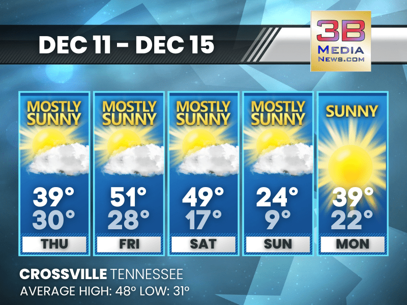
ARCTIC WEEKEND PLUNGE APPROACHES WITH BITTER COLD AND A CHANCE OF SNOW
A quiet stretch through Friday gives way to a sharp weekend cooldown, including a Saturday night chance for snow showers and single-digit lows by Sunday night. Today: Mostly sunny, with a high near ...

WINTER CHILL RETURNS MIDWEEK WITH GUSTY WINDS AND A LATE-WEEK WARMUP
A breezy, brisk stretch brings cold days and even colder nights before temperatures rebound heading into Friday, with a small chance of weekend showers. Wednesday: Partly sunny, with a high near 48 ...

TURNS COLDER MIDWEEK BEFORE A LATE-WEEK WARMUP RETURNS
A mix of sun and clouds brings breezy conditions through midweek, followed by a colder Thursday and a gradual warming trend heading into the weekend. Tuesday: Partly sunny, then gradually becoming ...

QUIET START TO THE WEEK BEFORE MIDWEEK SHOWERS RETURN
A mostly calm stretch gives way to increasing clouds and periodic showers from Wednesday night into Friday. Monday: A 20 percent chance of rain before 8am. Mostly cloudy, with a high near 40. North ...

WEEK BEGINS COLD AND CLOUDY, THEN TURNS MILDER WITH MIDWEEK SHOWERS
A stretch of chilly, mostly cloudy days will gradually warm by midweek, with increasing chances for showers Wednesday night through Thursday. Sunday: Mostly cloudy, with a high near 48. Calm wind b ...
CLOUDS EARLY, SOME RAIN CHANCES RETURN MIDWEEK
Clearing arrives later today, fog builds in tonight, and scattered light rain chances move through Sunday and again by midweek before brighter weather returns. Today: Cloudy through mid morning, th ...

FOGGY STARTS AND COLDER NIGHTS LEAD INTO A CHILLY, MIXED-PRECIP WEEKEND
Fog returns at times through the weekend, with a brief chance of showers and freezing rain Sunday night before colder, calmer weather settles in early next week. Friday: Patchy dense fog before 10a ...

SCHOOL CLOSINGS AND DELAYS FOR 12/05/25
The following schools will be closed Friday 12/5: Clay Overton Pickett Putnam Open but with a two hour delay: Cumberland Fentress Morgan Scott Oneida Specia ...