

COOLER THURSDAY BUT HOT WEDNESDAY
Looking at our weather map, a cold front will move across our area Wednesday late in the day and it is mostly dry but anytime a front moves into a hot air mass it can spark off an afternoon thundershower but our chances will only be slight and it would mainly be near the Kentucky Tennessee border . High temperatures will be in the upper 80s on Wednesday but only the upper 70s on Thursday. By the weekend highs will only be near 70 and lows around 48. I will be watching the radar Wednesday and let you know if anything pops up.
Related Posts
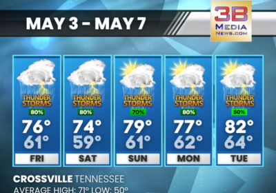
FRIDAY’S 5-DAY FORECAST
The risk for severe weather this weekend is low, but we could see heavy downpours…

THURSDAY’S 5-DAY FORECAST
Above normal temperatures with rain and storm chances in the forecast. Thursday: Sunny, with a high…
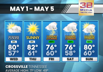
WEDNESDAY’S 5-DAY FORECAST
High pressure builds into the area Wednesday and Thursday, setting the stage for some warm…