FLORENCE ON TRACK FOR SOUTHEAST, EXPECTED TO BE MAJOR HURRICANE
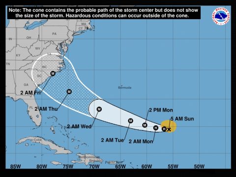
Tropical Storm Florence continued pushing toward the U.S. Southeast late Saturday, with forecasters predicting it will become “a dangerous major hurricane” posing “risk of direct impacts” by next weekend.
On its current track, Florence is expected to hit the Carolinas as a Category 4 hurricane early Friday morning.
A Category 4 hurricane packs winds of 131 to 155 mph and can cause catastrophic damage. Severe structural damage to frame homes, apartments, and shopping centers should be expected. Category 4 hurricanes often include long-term power outages and water shortages lasting from a few weeks to a few months.
But the National Hurricane Center cautioned that it was still too early to predict the “exact timing, location and magnitude of those impacts.”
The NHC did, however, advise officials from northern Florida up through North Carolina to monitor Florence’s progress and have emergency-response plans in place.
In an update, the NHC located Florence southeast of Bermuda, coursing westward at 6 mph with maximum sustained winds of 70 mph.
Ahead of the storm, governors of both North and South Carolina declared states of emergency. Virginia’s Governor Ralph Northum added his emergency declaration yesterday.
The step helps free government resources to provide emergency aid and other assistance in response to the storm.
North Carolina Governor Roy Cooper made his announcement Friday and also signed a transportation waiver that would allow farmers to harvest and transport their crops more quickly.
“While it’s still too early to know the storm’s path, we know we have to be prepared,” Cooper said. “During harvest, time is of the essence. Action today can avoid losses due to Florence.”
On Saturday, South Carolina Governor Henry McMaster followed suit.
Describing the storm as being “very unpredictable,” McMaster said the state would take cautionary measures.
“We are preparing for the worst and of course hoping for the best. Being prepared is always the best strategy,” McMaster said.
In Virginia, Northam said that while the impacts of the storm remained uncertain, they could include flooding, high winds and a possible storm surge.
The governor urged residents to assemble an emergency kit with food, water, medication, pet supplies and important documents. Coastal residents should also check what hurricane evacuation zone they live in.
Meanwhile, two other storms — Helene and Isaac — were following behind Florence in the Atlantic. Helene is expected to turn northward and away from any land. Isaac however, is on a path that will take it between South America and Puerto Rico by late Friday (September 14, 2018). On its current track, Isaac could enter the Gulf of Mexico sometime between Monday and Wednesday (September 17-19, 2018).


