

AREA FACING MODERATE TO ENHANCED RISK OF SEVERE WEATHER
The National Weather Service has upgraded an enhanced risk of severe weather to a moderate risk for this afternoon (Wednesday,April 5, 2017) and evening for a portion of the 105.7 The Hog listening area. The western parts of Roane and Morgan counties are in the moderate risk area as well as all of Cumberland, Fentress, Bledsoe and Overton counties. The remainder of the area remains under an enhanced risk.
Some strong to severe thunderstorms are now likely, mainly during the afternoon through early evening hours. Main concerns with strong to severe thunderstorms that do develop will be large hail, strong to damaging winds, and the formation of a few tornadoes. Some tornadoes could be strong and long tracked.
The estimated time frame of arrival for the storms is between 2 pm and 9 pm today. Stay tuned to 105.7 The Hog for live updates this afternoon from staff meteorologist Steve Norris. If your away from the radio, you can stream us on your phone, laptop or home computer by going to 1057the hog.com and click “open our media player”.
Related Posts
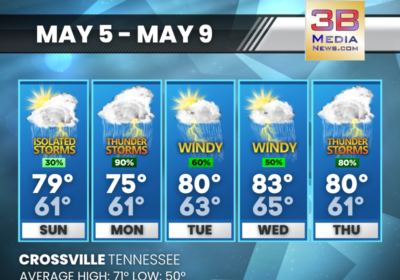
SUNDAY’S 5-DAY FORECAST
Scattered to numerous showers and thunderstorms are expected each day through at least Thursday. Temperatures…

TDOT RAMPING UP REPAVING EFFORTS STATEWIDE
The Tennessee Department of Transportation (TDOT) is ramping up its pavement repair efforts to address…
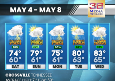
SATURDAY’S 5-DAY FORECAST
Saturday: Showers and thunderstorms, mainly before 4pm. High near 74. South southwest wind 5 to 10…