

Luvetta Adams, 59
Jennings - Luvetta Adams, age 59 of Jamestown, passed away on Wednesday, June 18, 2025 at the U.T. Medical Center in Jamestown. Private Funeral Services will be held at a later date. Luvetta is ...

ROCKSLIDE SHUTS DOWN I-40 AT NC BORDER
A rockslide shut down I-40 in both directions near mile marker 450 in Cocke County, Tennessee, on Wednesday afternoon, as announced by TDOT’s Mark Nagi. Drivers were advised to seek alternate routes, ...

CHILDREN’S COUGH SYRUP RECALLED FOR BACILLUS CONTAMINATION
TARRYTOWN, N.Y.--(GLOBE NEWSWIRE)—June 17, 2025—Medtech Products Inc., a Prestige Consumer Healthcare Inc. company (“Medtech” or “Company”), is voluntarily recalling five lots of Little Remedies® Hone ...
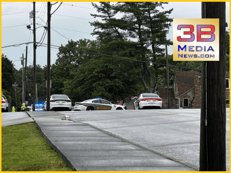
POLICE AND DEPUTIES RESPOND TO BARRICADED SUSPECT ON MAIN STREET
Crossville Police and Cumberland County Deputies briefly closed a section of Main Street near Cumberland Medical Center today due to a barricaded suspect. According to the TDOT SmartWay map, traffic h ...

ALMOST 250,000 MINIFRIDGES RECALLED; FIRE HAZARD
On June 18, 2025, approximately 249,100 AstroAI 4-Liter/6-Can minifridges were recalled due to an electrical switch defect that can cause short circuits, posing fire and burn hazards. The recalled uni ...

POLARIS RECALLS RANGER VEHICLES; FIRE HAZARD
On June 18, 2025, Polaris Industries recalled approximately 4,900 Model Year 2023-2024 Ranger XP Kinetic and Model Year 2025 Pro XD Kinetic Recreational Off-Road Vehicles (ROVs), along with 185 access ...

OVERTURNED SEMI CAUSING DELAYS ON I-40 WB (UPDATE)
A single vehicle crash involving an overturned semi occurred on Interstate 40 Westbound at Mile Marker 335.4 in Cumberland, Tennessee, reported at 2:57 AM CST on June 19, 2025. The westbound left lane ...

TENNESSEE HIGHWAY PATROL GRADUATES 33 STATE TROOPERS
On June 18, Tennessee Department of Safety and Homeland Security Commissioner Jeff Long and Tennessee Highway Patrol (THP) Colonel Matt Perry welcomed the newest graduating classes of Tennessee State ...

MULTI-VEHICLE CRASH AT THE SPLIT
On June 18, 2025, at 3:25 PM CDT, a multi-vehicle crash occurred on Interstate 40 Eastbound in Loudon County, Tennessee, at mile marker 368.2. The incident has resulted in the blockage of the left lan ...

Lacey Pryor Upshaw, 28
Hood - Lacey Pryor Upshaw , 28, of Crossville, Tennessee, passed away on June 17, 2025. Lacey was born on April 19, 1997, to Michael Pryor and Tracie Pryor (Geoffrey Woodall). She spent 11 years of ...

Josie Kathryn Cearley
Bilbrey - Our precious daughter, Josie Kathryn Cearley, was born sleeping on Sunday June 15, 2025 at Cumberland Medical Center. She weighed 5 lbs 7oz . and was 18 ¾” long. She is survived by her lovin ...

Tom Randy Davidson, 89
Bilbrey - Tom Randy Davidson, age 89, of Crab Orchard, TN, passed away at his home on June 16, 2025. Mr. Davidson was born on October 23, 1935, in Morgan County, TN, son of the late Jessie J Davids ...