

SEVERE THUNDERSTORM WARNING
BULLETIN – IMMEDIATE BROADCAST REQUESTED Severe Thunderstorm Warning National Weather Service Morristown TN 447 PM EDT Fri Aug 16 2024 The National Weather Service in

STRONG THUNDERSTORM COMING IN TO SOUTHWESTERN CUMBERLAND COUNTY
The Crossville/Cumberland County Emergency Management Agency said a strong thunderstorm will impact Southwestern Cumberland County through 2:45 p.m. At 203 PM CDT, Doppler radar was
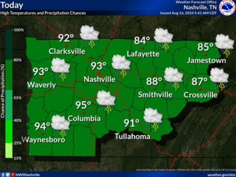
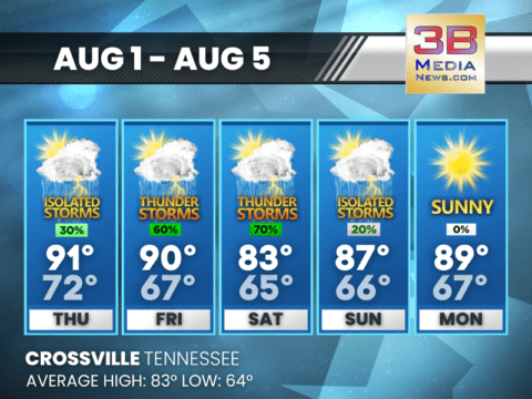
TODAY EXPECTED TO BE WARM, HUMID WITH STORMS POSSIBLY BECOMING SLIGHTLY SEVERE
It’s going to be a warm, humid Friday with storms likely throughout the day and into the evening. Some storms may become strong to severe,

THUNDERSTORMS LIKELY FRIDAY AND SATURDAY, CLEARING BY SUNDAY
Expect heavy rainfall and scattered thunderstorms through Saturday night, with a mix of sun and clouds on Sunday. Cooler, calmer conditions expected by Monday and

ALL OF MIDDLE TENNESSEE PLACED UNDER MARGINAL THUNDERSTORM RISK FOR FRIDAY
The Storm Prediction Center (SPC) has placed all of Middle Tennessee under a marginal risk for severe thunderstorms on Friday. Two rounds of showers &
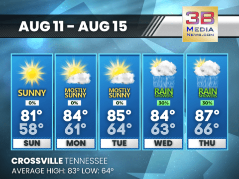
SUNNY SKIES AHEAD, THUNDERSTORMS LOOMING BY WEEK’S END
Expect warm and calm conditions through midweek, with highs reaching the mid-80s. Thunderstorms and showers are likely to move in Thursday night, continuing into the
WARM WEEK AHEAD WITH INCREASING CHANCES OF SHOWERS BY FRIDAY
Sunny skies dominate early in the week, but expect a gradual rise in rain and thunderstorms, peaking at 50% by Friday. Monday: Mostly sunny, with a
SUNNY SKIES TO START THE WEEK WITH A CHANCE OF MIDWEEK SHOWERS
Enjoy warm and mostly clear days through Tuesday, with highs reaching the mid-80s. Slight chances of showers and thunderstorms develop by Wednesday and continue into

USDA SAYS RECENT RAINFALL BRINGS IMPROVEMENT
Tennessee continued to see rainfall in some areas of the state. Temperatures and humidity are again on the rise. Over the last two weeks, producers

WARM AND SUNNY WEEK AHEAD
Mild nights and slight chance of showers on Friday, with temperatures ranging from mid-60s to low-90s. Monday: Patchy fog before 8am. Otherwise, sunny, with a high
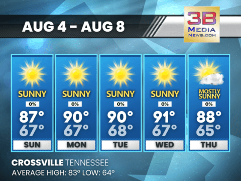
WARM AND SUNNY DAYS AHEAD WITH PATCHY FOG MORNINGS
Expect Highs Near 90 and Mostly Clear Nights Through Thursday Sunday: Patchy fog before 9am. Otherwise, sunny, with a high near 87. Calm wind becoming northeast
UNSETTLED WEATHER AHEAD WITH SHOWERS AND STORMS LIKELY
Thursday brings a mix of sun and scattered showers, while clear skies and cooler temperatures are expected by Sunday. Thursday: A 30 percent chance of showers

SEVERE THUNDERSTORM WARNING
BULLETIN - IMMEDIATE BROADCAST REQUESTED Severe Thunderstorm Warning National Weather Service Morristown TN 447 PM EDT Fri Aug 16 2024 The National Weather Service in Morristown has issued a ...

STRONG THUNDERSTORM COMING IN TO SOUTHWESTERN CUMBERLAND COUNTY
The Crossville/Cumberland County Emergency Management Agency said a strong thunderstorm will impact Southwestern Cumberland County through 2:45 p.m. At 203 PM CDT, Doppler radar was tracking a stro ...

TODAY EXPECTED TO BE WARM, HUMID WITH STORMS POSSIBLY BECOMING SLIGHTLY SEVERE
It's going to be a warm, humid Friday with storms likely throughout the day and into the evening. Some storms may become strong to severe, although the severe threat is low (only 1 out of 5). The main ...
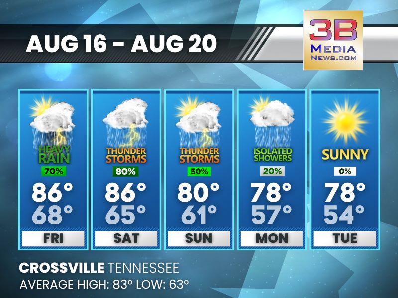
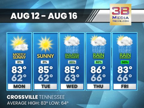
THUNDERSTORMS LIKELY FRIDAY AND SATURDAY, CLEARING BY SUNDAY
Expect heavy rainfall and scattered thunderstorms through Saturday night, with a mix of sun and clouds on Sunday. Cooler, calmer conditions expected by Monday and Tuesday. Friday: Showers and thund ...
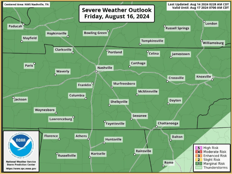
ALL OF MIDDLE TENNESSEE PLACED UNDER MARGINAL THUNDERSTORM RISK FOR FRIDAY
The Storm Prediction Center (SPC) has placed all of Middle Tennessee under a marginal risk for severe thunderstorms on Friday. Two rounds of showers & storms are expected on Friday, One during the ...

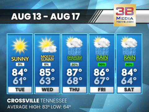
SUNNY SKIES AHEAD, THUNDERSTORMS LOOMING BY WEEK’S END
Expect warm and calm conditions through midweek, with highs reaching the mid-80s. Thunderstorms and showers are likely to move in Thursday night, continuing into the weekend. Tuesday: Sunny, with a ...

WARM WEEK AHEAD WITH INCREASING CHANCES OF SHOWERS BY FRIDAY
Sunny skies dominate early in the week, but expect a gradual rise in rain and thunderstorms, peaking at 50% by Friday. Monday: Mostly sunny, with a high near 83. Calm wind becoming north around 5 m ...

SUNNY SKIES TO START THE WEEK WITH A CHANCE OF MIDWEEK SHOWERS
Enjoy warm and mostly clear days through Tuesday, with highs reaching the mid-80s. Slight chances of showers and thunderstorms develop by Wednesday and continue into Thursday, bringing a brief break i ...
USDA SAYS RECENT RAINFALL BRINGS IMPROVEMENT
Tennessee continued to see rainfall in some areas of the state. Temperatures and humidity are again on the rise. Over the last two weeks, producers have seen conditions improve significantly for corn ...

WARM AND SUNNY WEEK AHEAD
Mild nights and slight chance of showers on Friday, with temperatures ranging from mid-60s to low-90s. Monday: Patchy fog before 8am. Otherwise, sunny, with a high near 89. Calm wind becoming east ...

WARM AND SUNNY DAYS AHEAD WITH PATCHY FOG MORNINGS
Expect Highs Near 90 and Mostly Clear Nights Through Thursday Sunday: Patchy fog before 9am. Otherwise, sunny, with a high near 87. Calm wind becoming northeast around 5 mph. Sunday Night: Patch ...

UNSETTLED WEATHER AHEAD WITH SHOWERS AND STORMS LIKELY
Thursday brings a mix of sun and scattered showers, while clear skies and cooler temperatures are expected by Sunday. Thursday: A 30 percent chance of showers and thunderstorms, mainly before 2pm. ...