
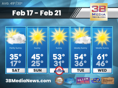
SATURDAY’S 5-DAY FORECAST
Cold air will continue to build in on Saturday and we will only see highs reach the 30s. Saturday: Partly sunny, with a high near
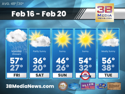
FRIDAY’S 5-DAY FORECAST
Rain returns Friday afternoon, followed by cold air and a chance for a rain/snow mix Friday night. As for snow accumulation, we aren’t expecting much
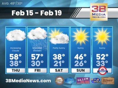
THURSDAY’S 5-DAY FORECAST
Our quiet weather will continue into Thursday with highs a few degrees warmer than today. Thursday: Increasing clouds, with a high near 58. West southwest
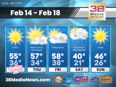
WEDNESDAY’S 5-DAY FORECAST
After a seasonably cool day Tuesday, temperatures will warm above normal for Wednesday and Thursday. Wednesday: Sunny, with a high near 55. West southwest wind
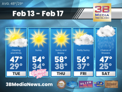
TUESDAY’S 5-DAY FORECAST
Dry weather will move in for Tuesday. Cooler air will arrive with near normal temperatures for this time of year. Tuesday: Mostly cloudy through mid

WINTER WEATHER ADVISORY FOR PORTIONS OF CUMBERLAND PLATEAU
The National Weather Service has issued a WINTER WEATHER ADVISORY for Cumberland, Fentress, Pickett, Clay, Overton, Putnam, and White County. The advisory goes into effect

WIND ADVISORY ISSUED
The National Weather Service has issued a Wind Advisory for the East Tennessee Mountains – including Blount County in the 3B Media News coverage area.
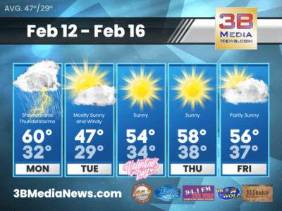
MONDAY’S 5-DAY FORECAST
A Flood Watch is in effect for portions of our area through Monday evening. There could be a few snowflakes flying north of I-40 and

FLOOD WATCH ISSUED
The National Weather Service has issued a Flood Watch from 10:00 PM EST / 9:00 PM CST this evening through Monday evening for portions of
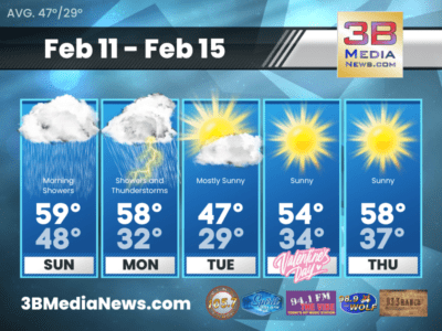
SUNDAY’S 5-DAY FORECAST
Sunday: Showers likely, mainly before 9am. Mostly cloudy, with a high near 59. North northeast wind 5 to 10 mph. Chance of precipitation is 60%.
SATURDAY’S 5-DAY FORECAST
Showers will increase in coverage as we go throughout the day today. Some rumbles of thunder and gusty winds will be possible, but mostly it
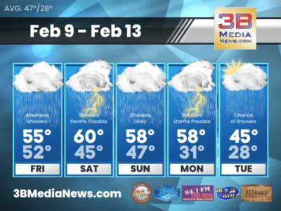
FRIDAY’S 5-DAY FORECAST
Friday: Showers, mainly after noon. High near 55. South wind around 10 mph. Chance of precipitation is 80%. New precipitation amounts between a quarter and

SATURDAY’S 5-DAY FORECAST
Cold air will continue to build in on Saturday and we will only see highs reach the 30s. Saturday: Partly sunny, with a high near 35. Northwest wind 10 to 15 mph, with gusts as high as 20 mph. S ...

FRIDAY’S 5-DAY FORECAST
Rain returns Friday afternoon, followed by cold air and a chance for a rain/snow mix Friday night. As for snow accumulation, we aren't expecting much with maybe up to a dusting on the Plateau. Rain to ...

THURSDAY’S 5-DAY FORECAST
Our quiet weather will continue into Thursday with highs a few degrees warmer than today. Thursday: Increasing clouds, with a high near 58. West southwest wind 10 to 15 mph, with gusts as high as 2 ...

WEDNESDAY’S 5-DAY FORECAST
After a seasonably cool day Tuesday, temperatures will warm above normal for Wednesday and Thursday. Wednesday: Sunny, with a high near 55. West southwest wind around 5 mph. Wednesday Night: Mos ...

TUESDAY’S 5-DAY FORECAST
Dry weather will move in for Tuesday. Cooler air will arrive with near normal temperatures for this time of year. Tuesday: Mostly cloudy through mid morning, then gradual clearing, with a high near ...

WINTER WEATHER ADVISORY FOR PORTIONS OF CUMBERLAND PLATEAU
The National Weather Service has issued a WINTER WEATHER ADVISORY for Cumberland, Fentress, Pickett, Clay, Overton, Putnam, and White County. The advisory goes into effect at 6 p.m. tonight (Monday ...

WIND ADVISORY ISSUED
The National Weather Service has issued a Wind Advisory for the East Tennessee Mountains - including Blount County in the 3B Media News coverage area. Southwest winds 20 to 30 mph with gusts up to ...

MONDAY’S 5-DAY FORECAST
A Flood Watch is in effect for portions of our area through Monday evening. There could be a few snowflakes flying north of I-40 and on the higher elevations of the Plateau Monday night - but no accum ...

FLOOD WATCH ISSUED
The National Weather Service has issued a Flood Watch from 10:00 PM EST / 9:00 PM CST this evening through Monday evening for portions of East Tennessee - including Blount, Rhea, Meigs, Monroe, Loudon ...

SUNDAY’S 5-DAY FORECAST
Sunday: Showers likely, mainly before 9am. Mostly cloudy, with a high near 59. North northeast wind 5 to 10 mph. Chance of precipitation is 60%. New precipitation amounts between a tenth and quarter o ...

SATURDAY’S 5-DAY FORECAST
Showers will increase in coverage as we go throughout the day today. Some rumbles of thunder and gusty winds will be possible, but mostly it will just be a cloudy wet day. Saturday: Showers and pos ...

FRIDAY’S 5-DAY FORECAST
Friday: Showers, mainly after noon. High near 55. South wind around 10 mph. Chance of precipitation is 80%. New precipitation amounts between a quarter and half of an inch possible. Friday Night: S ...